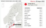
What's the weather where you are?

Stockholm, Sweden
20 Aug 2022

2022-08-19-06-30-42.jpg

We had another period of high temperatures

during August giving the month a fantastic summer feeling, with a summer peak period (since July wasn't really that great). Yesterday the peak was reached in the city center with 31.8°C (87.8°F). Lately, I have been at work during night time with just a uniform short sleeve T-Shirt on. However, being pretty late into August - a lot of moist air was transported into our region, which gave rise to plenty of clouds, and fog has started to appear in the early morning hours.


Right now / today

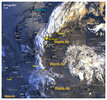
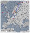
a cold front is passing slowly over Stockholm, and we finally got some rain - albeit very gentle amounts. (No thunderstorms have reached the city *buhuuu*) They all disintegrated on their way to us. At the same time, the temperatures this morning haven't gone down below 20°C, right at the threshold of a "tropical night".


2022-08-20-08-28-07.jpg


August 2022
has this far shown a large surplus of warmth this year, giving summer a real, second peak after all (together with June 2022).

_-2022-08-20-at-08.14.42.jpg


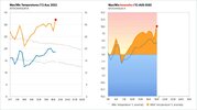
Year 2022 so far

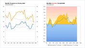
Here, I made a graph to show you, how the MAX & MIN temperatures have been during this year in the city center of Stockholm (which doesn't show the cold nights of e.g. May, as those never get so cold in the city).
_-2022-08-20-at-08.22.30.jpg


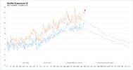
Based on the same graph, only that here you see the deviations/anomalies compared to normal MIN & MAX temperatures.

_-2022-08-20-at-08.22.19.jpg

The outlook

calls for cooler weather of course, but warmer than normal. After all, in the end of August the average MAX goes down to "only" 18-19°C in Stockholm, but 22-23°C are predicted; e.g. a very nice round up for this summer :-)
 
En France Côte d'Azur entre Nice et Cannes : Cagnes sur Mer
Nous avons eu de l'orage avec de la pluie assez forte par intermittence Mercredi et jeudi dernier...
Les températures descendent un peu 20° la nuit et 27° le jour...
Depuis hier le soleil et le ciel bleu sont revenus, il est 11h18 il fait 29°...
Rien à voir avec ce qui s'est passé en Corse, Ile juste en Face de nous en Méditerranée

In France French Riviera between Nice and Cannes : Cagnes sur Mer
We had thunderstorms with quite heavy rain intermittently last Wednesday and Thursday...
Temperatures went down a bit 20° at night and 27° during the day...
Since yesterday the sun and the blue sky came back, it's 11:18 am it's 29°...
Nothing to do with what happened in Corsica, island just in front of us in the Mediterranean Sea...

Translated with www.DeepL.com/Translator (free version)
 
It has been a week of cold temperatures in the Toluca Valley in central Mexico, near 11 degrees Celsius in the mornings. There has been moderate rainfall but it is nothing compared to what is happening in the north and south of the country where torrential rains have wreaked havoc this week. In Toluca, light rains will be recorded due to a tropical cyclone that formed in the Gulf of Mexico, however, heavy rains are expected for the northeast.

Tropical cyclone potential moving over the SW Gulf of Mexico towards NE Mexico 🇲🇽 and SE Texas 🇺🇸
Tropical #TropicalStorm warning from Boca de Catan to Matamoros Tamaulipas.
-Winds 55km/h
Moving NW 22km/h
CAUTION ☔
 
Austria
Southern part of Lower Austria:

Weeks and weeks and weeks of hot temperature and nearly no rain - besides some days with a litte rain that had no effect. Temperature most above 31° C often about 34-36°C. Yesterday temperatures went down to 17°C, and we were hopefully trusting the weather forecast that promised rain. What we got was 1 mm of water. The whole area meanwhile is dry, corn and soybeans are dried out. And even the trees on the small hills beside my place are getting brown. Mostly the pines, and I think they will not recover any more. On the other hand:

Southern Part of Austria, Carinthia and Styria
There were really heavy storms and much rain last thursday, 5 people were killed, 3 from a lightning, 2 children due to falling trees, a lot of people seem to be hurt. Railways did not work due to trees falling on the rails, one big highway had to be closed also due to falling trees. About 50.000 people without electricity. Really disastrous, as it looks like.

On the other hand as @Alix mentioned it turns out (even in some newspapers) that there have been always droughts like that one we have now. So if one is willing one can see now that this is a normal cycle of the earth and the CO2-Hysteria definitely is wrong.
I enclose pictures, one of the damage made by the storm the other ones as a good example of showing the lies.

The text from meteo sat Schweiz goes:
Historical: In the summer of 1540, Lake Constance had dried up, wells that still contained water were observed, water only came when the bell struck. (Note: Where were the planes and cars in 1540!?) (Because of CO2)
 

Attachments

  • strommastgeknickt.jpeg
    strommastgeknickt.jpeg
    51.4 KB · Views: 10
  • elbe.jpeg
    elbe.jpeg
    103.4 KB · Views: 10
  • bodensee.jpeg
    bodensee.jpeg
    69.3 KB · Views: 10
Hungary, ~90 miles west of the Ukrainian border:

Drought was broken up by 4-5 days of mild rains - totaling to 20mm. Soaking the soil with rainwater nicely. Next week another rain salvo arrives, though much less, expected 5mm total in the course of 4 days..

- Crops destroyed by drought raises prices - my egg-man Obyvatel complained. On the flea-market he also had his 'war-veteran tomatoes' on display, which were big, but had thick, grey-green-brown drought streaks / burn wounds and looked like Tomatoes from Hell. Or at least 'Tomatoes from the House of Pestilence'. He offered a kilogram of those frightening tomato-beasts at an astonishing astronomical price level of almost a kilogram of meat..

Considering tomatoes are merely tolerated by the human body and are of near zero nutritional value, it made me thinking:

The main nutrition for the 'human body & soul'-complex are strong impressions. Just as Gurdjieff taught. Without strong, energizing impressions that have major effect on the immediate future I feel weak, powerless, trudging along in a vegetative / comatose state. Lack of proper impressions makes me feel constantly depleted and feel like shoveled horse dung..

I wonder, if this lethargic & 'nearing body-death' sensation stems from sensing that Cosmic Changes are Ante Portas, which (I expect) will make some peeps able to draw on the previously unavailable currents, energies of the Universe?

Lessening the need for physical food considerably by taking up energy in a never before seen manner? And sensing that a change in cosmic conditions are near my soul starts to remember how energized I was in 4thD & 5thD? Compared to that highly energized state, expecting it to arrive.. and it generates a marrow-deep sensation of being completely depleted and dying energetically, because that may be the difference between the current pathetic human energy levels --versus-- leading the '1000x times charged 4thD' way of life in the future?

How does this pertain to weather? Well, I expect to take above mentioned energies from the suddenly highly energized environment, which I expect will charge up / make more intense the weather-system. Then the lifestyle of the past 51 years will change drastically. Regards cooking & need to eat physical food, sleeping - need to sleep for hours to recharge only minimally, needing a roof of a house above my head.. Just about all the little aspects of life that a man needs and which so far keeps humans kicking..

Just a thought..
 
Last edited:
The Netherlands has managed another record, this time it's about the number of sun-hours this summer.
Source (in Dutch): KNMI: Zomer nu al recordzonnig, meer zon dan in 1976

KNMI: Summer already record sunny, more sun than in 1976

The summer sun has already shone more often this year than in any other summer season since measurements began in 1965, according to weather institute KNMI. The old record from 1976 has thus been broken, four days before the end of the meteorological summer.

ANP - August 27, 2022, 18:25

According to the KNMI, this year's sunny summer "fits the trend of increasing solar radiation in the Netherlands since the 1990s. For example, there has been a 3% increase in solar radiation per decade; in the spring, the figure is even 5%.

The weather institute calculates the national solar radiation from the average solar radiation measured at five KNMI stations: De Kooy (near Den Helder), Eelde (near Groningen), De Bilt, Vlissingen and Maastricht.

The old record from 1976 stood at an average solar radiation of 229 W/m2 (watts per square meter). This year, according to KNMI, the average is higher at about 238 W/m2. The average value over the years 1991-2020 is 206 watts per square meter.

Incidentally, solar radiation is not distributed equally across the country. The west coast receives on average 9 percent more sunshine in summer than the east of the country, 216 versus 199 W/m2.

More sunshine in the spring and summer contributes to the warming of the Netherlands, according to the weather institute, in addition to the global temperature increase. This also leads to a precipitation deficit. Incidentally, according to the KNMI, solar radiation is increasing throughout most of Europe. This is partly due to the reduction in cloud cover caused by an increasing number of high-pressure areas in the spring and summer, and partly because the air has become cleaner.

'Based on calculations with climate models, in the upper KNMI climate scenario we are taking into account a normal value of 219 W/m2 around 2085, an increase of more than 6 percent compared to the current climate normal,' says the weather institute. 'We therefore expect the current trend of 3 percent per decade to level off in the future, as we experience more frequent cloudy summer weather. In addition to human-induced global warming, natural variations in weather continue to have a major influence on solar radiation, drought and temperature in the Netherlands.'

Translated with www.DeepL.com/Translator (free version)

Similar coverage (in Dutch):
Zo'n zonnige zomer hadden we nog nooit: 46 jaar oud record uit de boeken
Nooit eerder zoveel zonneschijn in Nederlandse zomer
KNMI: Zomer nu al recordzonnig, meer zon dan in 1976
 
Stockholm, Sweden
28 Aug 2022

"Welcome to Africa... uhm... I mean Stockholm".

The city along with parts of the east coast of Sweden, is still under the influence of subtropical air - for the few hours that are left. Once a weather front, just west of us will swoop away high season summer for this year. August has been exceptionally warm and made our summer feel extended. Only yesterday it was 27.3°C or (80.6°F) in the city (The MAX was 7°C above normal for this time of the year). And the night was once again, very mild - in some places almost tropical (near the sea)

2022-08-28-05-44-52.jpg
Sunrise at our kitchen window around 05:44 with a 840 mm telephoto lens.

2022-08-28-05-36-53.jpg 2022-08-28-05-32-07.jpg
At sunrise on my way home, creating pretty colors in the high clouds around 05:32


2022-08-28-05-31-03.jpgTowards the west and southwest, you can see that the weather front showing instability, Ac/Sc castellanus (little towers) are clouds which often signal impending Thunderstorms and showers. Over there in the distance around 60 km away , lies the rain (and t-storms) which had been going on for many hours.


Special weather situations

I have always been fascinated about weather situations in which a city is flanked by "extremes". Such as, when very warm air is stretching like a slim corridor across an area, while much colder air flanks each side of the city. Or when the seasons last hot air is getting swooped away, but leaves a pocket still, extending the warm feeling in the air for some more hours. Like on this morning...


During the past 12-18 hours

A weather front in the west has been very close to the city - with plenty of rain in the affected areas (45 mm in Malexander), and thunderstorms, stretching all the way up to Uppsala and Stockholm Arlanda Airport, but without really touching the city other than a few raindrops. The temperature remained were mild here - I didn't even bring a jacket to work during my night shift as a train driver of the Stockholm metro. I saw distant lightning passing by, narrowing down to perhaps 60 km at the most, but then shifted towards the island of Åland and towards Turku in West Finland.

_-2022-08-28-at-06.37.00.jpgDWDEU_0.jpg


Distant lightning without sound / Heat lightning

Probably what Quill described in the previous post; now being the time of lightning in Finland without sound, seen from a long distance. I might just been that cluster of thunderstorms, which originated over Svealand. (middle Sweden) The other night i saw lightning over the Baltic sea, which was a T-storm cell over 200 km away. Since the Baltic sea is very warm right now, up to 21-22°C - there is plenty of opportunity for thunderstorms to develop (or to be maintained), especially since much colder air will soon swoop over the warm sea water, by tapping into all that stored energy.


_-2022-08-28-at-06.56.22.jpg


Well then; Good Bye Summer

So, this is the last sunset with a feeling of high season summer - because from here on - it looks as if we will get much cooler weather in Stockholm, barely reaching 20°C. Plenty of rain is expected for today and tomorrow, up to a total of 27 mm - which i am sure will do really good to all vegetation. The pine tree in front of my balcony, looks really stressed with its many yellow-brownish needles.

It may get as cold as barely reaching 13-14°C (maximum) during the upcoming week. With night temperatures down to 6°C, which i am sure will be even lower in the suburbs. Ground frost anyone ? Time will tell... After that, a little warmer weather can be expected again.

It sounds like autumn - but hey, this is Scandinavia after all...
 
Just a shorter addition
Sweden, 28 Aug 2022

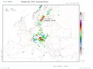
Apparently the Swedish weather station Malexander i mentioned earlier, received not 45 mm, but almost twice as much; 86+ mm rain. Worst in class turned out to be Linköping-Malmslätt, (middle South Sweden) preliminary received as much as 141 mm rain (5.51 inch) - the station that got most rain in entire Europe 27-28 Aug 2022.

RR24h_obs_eu-large_day0.png
Notice: The chart above only shows 24 hours up until 08.00 local time this morning 28 Aug 2022,
in which Linköping received 102 mm rain but not covering all rain yet.


Still a tiny pocket of hot air

managed to cover the island of Gotland in the Baltic Sea today, where the temperature climbed up to 29.4°C - which I find fascinating. Even Helsinki/Finland still resided within the corridor of warm air, and got at least 26°C.

_-2022-08-28-at-20.30.33.jpg

The Switch at home
South Stockholm

🔸 I went to work yesterday evening around 21:00, left my jacket at home, because it was unusual warm with 21.5°C
🔸 In the morning after work, 06:00 it was 18°C.
🔹 Now while I am writing at 21:00 , it is a mere 11°C
 
Here in Spain (not where I live) a big hail tempest yesterday at Gerona, Catalonia. Around 100 people were injured by hail balls measuring between 10 and 15 centimeters, cars destroyed, roofs destroyed and a 20-month-old girl died when she received a hail stone on her head. It seems that the sky was in a bad mood yesterday!

 
In the south-east of England where I live the weather continues to be very dry with small outbreaks of rain but nothing much. The temperatures continue to be quite high for this time of year. Supposedly 26 C tomorrow. However the long range BBC forecast is showing rain for five consecutive days starting on Sunday. I will look forward to this providing it actually happens this time. I am giving my three tall hedges a hair cut which I hope will be the last of the season (I have no love of balancing in mid air on a very shaky ladder). If I don't do it and it starts to rain continually it is sometimes impossible to cut them again. However, this is going by previous years experience. This year is quite exceptional weatherwise.
 
Back
Top Bottom