Volcanoes Erupting All Over

Askja, Iceland
13 Feb 2021

Something is going on with the Askja Volcano, on Iceland...

🇩🇪

Askja volcano with increased geothermal energy
13 February 2023 by Marc Szeglat


Size of ice-free area in Askja's caldera doubled
State: Iceland | Coordinates: 65.03, -16.75 | Activity: Fumarolic

askja-1-1018x720.jpg

The heat flow from the bottom of Öskjuvatn, the lake that occupies a good part of the Askja caldera, has doubled since yesterday. In the latest sentinel photo, you can now see 2 large ice-free patches. Ground uplift at the OLAC gauging station has continued to increase and is now 51 cm. Icelandic scientists believe that the caldera floor is uplifting due to a magma intrusion that started in August/September 2021. It is not unlikely that we will see a volcanic eruption there soon. But before volcano spotters' hearts do double-takes, I would like to point out that the volcano is accessible during the winter at best by specially equipped jeeps (monster trucks). If there is an explosive eruption, access to the volcano will certainly be closed altogether. It is not yet possible to predict whether there will be an explosive or effusive eruption, if that should happen.

A Vnet reader asked whether the ground uplift at Askja could be a phenomenon similar to that at Campi Flegrei. There, the ground rises and falls in irregular cycles, sometimes even by several metres. In the current cycle, the ground has already risen by more than one metre. In fact, two uplift phases and three subsidence phases have already been observed at Askja in the period 1966 to 1987. The measurements began in 1966 and were carried out once a year. At that time, there were no independently operating measuring stations. A maximum annual uplift of 20 cm was assumed. In the current uplift phase, the third since measurements began, this value has already been exceeded. But an eruption does not necessarily have to occur. Nevertheless, scientists suspect that the uplift of Askja is caused by magma that collects at a depth of 3 km. At the Campi Flegrei, the bradyseismos is probably caused by magmatic fluids circulating in the volcano's hydrothermal system. However, the fluids there also emanate from a deeper-seated magma body that is located under a stable cover layer.


END OF ARTICLE

IcelandColorMap08.jpg
 
Nyamuragira Volcano, Congo
15 Feb 2023


FBTg0OmXIAAts5n-1.jpg

Nyamuragira volcano emits very high thermal radiation


The Congolese Virunga volcano Nyamuragira emitted very high thermal radiation again today with a power of 1635 MW. It is displayed at MIROVA. It is very likely that the crater has been flooded with lava again. We have seen such events several times in the last months. Mostly they are effusive eruptions that produce lava flows within the caldera. The lava can build up into a secondary lava lake. A true lava lake with its own circulation did not form recently.

At the neighbouring volcano Nyiragongo, high heat radiation with peak values of up to 324 MW was registered in the last 2 days. A sporadically active lava fountain may have formed in the crater. Unfortunately, visual observations are still pending.

The political situation in the DRC did not take a turn for the better. On the contrary, it was reported yesterday from the neighbouring province of Ituri that rebels and Islamists attacked several villages and killed at least 30 civilians. Similar incidents occurred only 3 weeks ago. Ituri is located on Lake Albert, one of the large lakes in the western arm of the Great African Rift Valley. Our two volcanoes are in the province of North Kivu.

There, too, more than 120 rebel groups are rampaging, commanded by the so-called warlords. While most of the rebels are ostensibly fighting against state oppression, including control of the region's mineral resources, more and more Islamist groups have become involved in recent years, targeting Christian communities and their churches. It does not look like this will change in the next few years, and so the Virunga volcanoes are becoming more and more distant for us. Years ago, climbing Nyiragongo was only possible in the company of armed rangers. With the current situation, one can only advise against travelling there.


END OF ARTICLE
 
Unknown Volcano, Indonesia
15 Feb 2023


New underwater volcano discovered off Indonesia
by Marc Szeglat

sea.jpg


Yesterday it was announced that a new underwater volcano has been discovered off the coast of the Indonesian island of Java. It is located about 260 kilometres south of the Pacitan district, right on the border between the provinces of Central Java and East Java. The still unnamed underwater volcano was discovered by a survey team from the Centre for Mapping of Marine and Coastal Areas (PKLP) of the Geoinformation Agency (BIG).
Speaking to news agencies, BIG's marine area mapping coordinator Fajar Triady Mugiarto said the base of the mount is on the seabed at a depth of about six thousand metres. The seamount itself is about 2,200 metres high.

The underwater volcano was discovered during the 52-day survey by the BRIN survey vessel Baruna Jaya III. The aim of the expedition was to obtain detailed data on the underwater topography. The data will be used to calculate the claim to the extended continental shelf area.

The coordinator said that BIG held a technical coordination meeting with a number of parties, namely geologists and hydrographers, as well as representatives from the Pacitan District Government and the East Java Provincial Government regarding the discovery of the seamount.

Currently, the Pacitan district government is working on a proposal for the naming of the new underwater mountain.

"Hopefully, the name of this volcano will later be included in Indonesia's geographical directory," said the BIG official.

The plan is to submit the name of the newly discovered underwater mountain to the Subcommittee on Naming Underwater Objects (SCUFN) of the General Bathymetric Chart of the Oceans (GEBCO).

The GEBCO is under the auspices of the International Hydrographic Organization (IHO) and the Intergovernmental Oceanographic Commission (IOC) of the United Nations Educational, Scientific and Cultural Organization (UNESCO).

While there are about 1900 volcanoes classified as active on land, experts believe that there could be a million underwater volcanoes hidden at the bottom of the oceans. (Source Antares)


END OF ARTICLE
 
Askja, Iceland
16 Feb 2023

The Icelandic volcano Askja appears to get more and more unsettled, and vulcanologists are thinking that magma is now rising after it collected for several years under the volcano. German Vulkane.net wrote following today:


Askja continues to heat up
by Marc Szeglat

State: Iceland | Coordinates: 65.03, -16.75 | Eruption: Fumarolic

The Askja volcano is located in the Icelandic highlands within sight of Herdubreid and the island's largest glacier, Vatnajökull. Since the weekend, it has been known that the winter ice on the caldera lake Öskjuvatn is melting. First, a relatively small area was ice-free, which quickly expanded until only half of the lake was covered with ice. Meanwhile, the ice melt appears to be stagnating and not expanding any further, although the remaining ice is shifting and moving across the lake.

Permanently ice-free is an area in the southwest of the lake, approximately where the OLAC measuring station is located on the lakeshore, where the largest ground uplift of 50 cm was recorded so far. Icelandic scientists speculate that the magma has begun to rise and that the volcano is preparing for an eruption. What I think is missing so far are clear seismic signals that magma is rising and triggering volcanotectonic earthquakes. Although the seismicity in the area has increased since yesterday and IMO registered 52 quakes in the Vatnajökull area within 48 hours, we are still far away from a massive swarm quake as usually triggered by magma rise.

In the volcanic eruptions of recent years, we experienced thousands of tremors in the weeks and days before an eruption. Only Hekla is known to start eruptions without a prior seismic crisis. In addition, earthquakes were recorded today in several regions along Iceland's rift zones, so it is not clear whether the tremors in the Vatnajökull area are a regional phenomenon or whether the entire system was affected by a seismic thrust.

There were 54 quakes along the Reykjanes Peninsula, 32 in the south of Iceland and 21 at the TFZ. Looking more closely at the Askja seismogram, however, there appear to be numerous microquakes. A thickened baseline could be caused by weak tremors or strong winds. Probably the latter is the case, because there is nothing noticeable on the tremor graph.

as.jpg 230216_1210.jpg ask_highpass_2.0-1.png

But one thing seems certain: quite a bit of magma has accumulated under Askja in recent years. Heat rises and melts the ice on the lake. An eruption could happen within hours. But it is more likely that it will take several weeks until then, if there will be a volcanic eruption at all. I assume that a seismic crisis will begin at least a few hours before an eruption. The eruptions of Eyjafjallajökull, Bardarbunga and Fagradalsfjall rattled for several weeks before they started. It is also clear, however, that although there are parallels between the various eruptions, volcanoes do not follow rules. So it remains exciting!


END OF ARTICLE
 
Karangetang, island of Api Siau, Indonesia
16 Feb 2023

Increased rumbling and activity from an Indonesia volcano. The last of the three photos suggests that villages are dangerously close by...


Karangetang on Api Siau increases activity
written by Marc Szeglat | Vulkane.net


Karangetang on Api Siau increased its activity in the last few hours. VAAC reported volcanic ash at an altitude of 2400m. It is drifting towards the southeast. In the VSI/MAGMA reports, which come out every 6 hours, there are not many words around the volcano, but you can see photos of the volcano taken from the local observatory. The most recent image shows ash emissions, older images from tonight and the morning hours reveal debris avalanches that leave red glide marks on the photographs at night. It can be concluded that the lava dome has reached a critical size and that there is demolition at its edge. Possibly a small lava tongue is already pushing over the upper flank area. The seismic histogram does not load today, but the VSI summaries indicate that seismicity is low.

The activity was preceded by increased seismicity in the Moluccas area. There were numerous moderate and stronger earthquakes there in January. They may have shaken up the Karangetang. In the meantime, earthquake activity has returned to normal levels.


KAR202302151800.jpg
KAR202302160000.jpg KAR202302161200.jpg

Karangetang is a 1827 m high stratovolcano, at the foot of which villages are located. It has a double peak with one crater each. Often, a lava dome grows in one of the craters, while the other is strombolian active. However, strombolian eruptions from the lava dome also occur, especially during periods of increased activity. Viscous andesitic lava flows can reach settlements. The danger of pyroclastic flows is high. They often reach inhabited areas and claim lives. For the last time, a pyroclastic flow reached inhabited areas in May 2015 and destroyed parts of Kora village. In 2019, a lava flow stopped short of a village.


END OF ARTICLE


From Wikipedia:

Karangetang (also known as Api Siau) is a volcano on the north side of Siau Island off the coast of Sulawesi, Indonesia. The island is inhabited by 22,000 people.[2] It is one of the most active volcanoes in Indonesia having erupted 41 times since 1675. A pyroclastic flow in 1997 killed three people.[3]

Current activity

• In August 2007 an eruptive episode forced evacuations from nearby areas.[4]
• On 9 June 2009 the Volcanological Survey of Indonesia raised the eruption alert status of Karangetang to Level Orange.[5]
• On 6 August 2010 Karangetang again erupted, spewing lava and ash hundreds of meters into the air. Four villagers are missing.[6][7]
• On 11 March 2011, a few hours after an earthquake in Japan caused a Pacific-wide tsunami, Mount Karangetang again erupted.[8] There were no reports of serious damage or deaths, though lava and hot gas clouds were emitted onto its slopes.[8]
• On September 2, 2013, the volcano began erupting again.
• There was another spell of activity from November 2018 onwards, and yet others between 2013 and that.
• On 20 July 2019 a new eruption started, continuing as of October 2019. This was accompanied by effusion of lava.
[9]

_-2023-02-16-at-18.34.41.jpg
 
Popocatépetl volcano explosion tonight in #Mexico
Burst and ejection of incandescent material over the crater, high emission column.
Volcanic Alert unchanged at Yellow Phase2
February 24/22:36h local time (04:36 UTC)

CENAPRED reports that in the last 24 hours, through the monitoring systems of the Popocatepetl volcano, 231 exhalations accompanied by steam, volcanic gases and sometimes light amounts of ash were detected. Additionally, 113 minutes of tremor were recorded, of which 36 minutes were of the harmonic type.

During the morning, a constant emission of water vapor, volcanic gases and light amounts of ash was observed in a west-northwest (WNW) direction.
 
Japan has gained 7000 islands since 1987. The article claims that the newly discovered islands being found is the result of improvements in surveying technology, but since islands are formed as a result of volcanic activity, have to wonder if there's more going on here.

Japan has recounted its islands and discovered it has 7,000 more than it previously thought.
Digital mapping by the Geospatial Information Authority of Japan (GSI) recently found there to be 14,125 islands in Japanese territory, more than double the figure of 6852 that has been in official use since a 1987 report by Japan's Coast Guard.
However, the GSI this week stressed that the new figure reflected advances in surveying technology and the detail of the maps used for the count - it did not change the overall area of land in Japan's possession.
It said that while there is no international agreement on how to count islands, it had used the same size criterion as the previous survey 35 years ago.
That entailed counting all naturally occurring land areas with a circumference of at least 100 meters (330 feet).
The new number does not include any artificially reclaimed land.

 
Japan has gained 7000 islands since 1987. The article claims that the newly discovered islands being found is the result of improvements in surveying technology, but since islands are formed as a result of volcanic activity, have to wonder if there's more going on here.

The link says here: 404- Sorry, page not found.
So, I've search with the title and I found it (with a sequence of numbers after the title in letters that is not in the previous link): Japan just found 7,000 islands it didn't know it had

And I found on Kyodo News that another reason for the "increase" of number of islands could partly be because of what I put in bold:
The government has been using the figure released in 1987 by the Japan Coast Guard. At the time, the coast guard listed by hand islands with a circumference of 100 meters or greater shown on a map of Japan. Islands in lakes or river sandbanks were not included in the total.

In the latest survey, the government counted islands automatically using a computer based on GSI's electronic land map in 2022 and cross-referenced the map with past aerial photographs and other data in order to exclude artificially reclaimed land.

While the computer detected over 100,000 islands, only those with circumferences of 100 meters or greater were selected for the official list.

That does not take away the fact that several islands must have indeed risen from the sea due to the sustained volcanic activity in Japan.
 
The ice that covers the lake at Iceland's #Askja volcano during the winter season is rapidly melting. Is the arrival of spring to blame? No, geothermal activity has increased, possible eruption in the future?
--
The melting of the ice that covered the entire surface of the lake present inside Askja crater began over a month ago. After monitoring the situation from afar with satellite images, scientists flew over the lake last week.
--
During the flyover, Icelandic researchers used thermal cameras to try to determine the surface temperature of the lake's waters. And well, from this it became clear that the water had warmed markedly, reaching temperatures well above average.
--
The cause of this increase in temperature is likely to be attributed to an intensification of the volcano's geothermal activity. Askja has in fact been in an unrest (agitation) phase since August 2021. Since then, magmatic intrusion has been ongoing at a depth of 2-3 km.
---
This has caused an uplift of the caldera floor of more than 50 cm, which is very significant. Not all intrusions culminate in an eruption, however, and consequently we do not know if this one will, or possibly when it will. Stay tuned! 🌋
 
Civil Protection warns of activity in Salvadoran volcano Chaparrastique

The Directorate General of Civil Protection has issued a warning on Wednesday about activity at the Chaparrastique volcano, located in eastern El Salvador, which erupted on December 29, 2013.

According to a report from the Directorate of the Observatory of Threats of the Ministry of Environment and Natural Resources (MARN), "an increase in the degassing of the volcano is observed from its central crater, being constant, during the early morning and early hours" of today, notes Civil Protection in a statement.

It indicates that the emission of magmatic gases "is continuous, seismicity records show an increase in activity related to the passage of gases from inside the volcano, so it is more likely to observe these periods of outgassing and explosions accompanied by ash.

Civil Protection indicates that it has activated the protocols in the surroundings of Chaparrastique volcano, the most active volcano in the country, and that it maintains constant monitoring in the area.

Chaparrastique is located about 2,130 meters above sea level and its last eruption, before the one in 2013, was in 1976, according to data from the Ministry of Environment, which maintains a permanent surveillance of about eight active volcanoes. EFE

 
Chiles volcano records swarm of more than 200 earthquakes in less than 24 hours in Ecuador and Colombia

The Geophysical Institute (IG) has reported that since 11:00 on Thursday, March 9, there has been a swarm of earthquakes in the Chiles volcano, which is located in the territories of Carchi (Ecuador) and Nariño (Colombia).

Up to the moment of its report issued at 21:15, 200 seismic events have been registered in the province of Carchi and in the Colombian department of Ñariño, which are located on the border between Ecuador and Colombia.

Although earthquakes have been felt in some areas, they have been of low magnitude, the strongest being the one recorded at 20:10 in the Colombian municipality of Cumbal, Department of Nariño, with a magnitude of 3.6, which was also felt in the province of Carchi.

So far, no material damage or injuries have been reported as a result of the seismic swarm.

A seismic swarm is characterized by the occurrence of several seismic events in a period of time and in a limited geographic area, without the identification of a main earthquake and its subsequent aftershocks.

Special Seismic Report N° 2023-002
SEISMIC SWARM IN THE VOLCANIC COMPLEX CHILES - CERRO NEGRO

March 10, 2023Since yesterday, around 11:00 local time (LT), the National Seismic Network (RENSIG) together with the network of the Volcanological Observatory of Pasto (OVP-Colombia), recorded a seismic swarm (Figure 1.a) in the sector of the Chiles-Cerro Negro Volcanic Complex (CVCCN). At 20:10 LT yesterday, an earthquake of magnitude 3.4 Mlv was recorded as part of this swarm, which was felt by residents located near the CVCCN area. At the moment the rate of occurrence of seismicity is around 200 events per hour, which correspond mostly to volcano-tectonic events (indicating rock fracturing), with important components of very low frequency (VLP), which are associated with fluid migration. So far, at least 4500 events associated with this swarm have been recorded. These seismic swarms in the CVCCN occur regularly.

Associated with these swarms there is a higher probability that additional seismicity is triggered towards the ESE, near the Potrerillos region. It is worth mentioning that on previous occasions, associated with these swarms, events of significant magnitudes capable of causing damage have been recorded, especially in vulnerable constructions, such as the Mw=5.6 magnitude earthquake that occurred on July 25, 2022, which is why the generation of strong earthquakes in the area should not be ruled out.
 
New eruptive pulse of #Volcano #Merapi in #Java #Indonesia 🇮🇩

Mount Merapi ejected pyroclastic flows that slid down slopes prompting alert from local authorities.
March 11/12:12 local time
Via @merapi_uncover

Merapi Volcano Volcanic Ash Advisory: ERUPTION UNDERWAY HEIGHT UNKNOWN OBS VA DTG: 11/0530Z

 
Interesting Etna's volcano eruption on 1669 thread.


On March 11, 354 years ago, the largest and most important lateral eruption ever to occur on #Etna in historical times was about to begin. It was an almost volcanologically and culturally watershed event for the Etna region. 🧵

The eruption was preceded by a full-bodied and intense seismic sequence that affected the slopes of the volcano since February. This sequence peaked on the night of March 10-11, that is, a few hours before the eruption began. 2/10

At 4:30 p.m. on the same day, as many as five different eruptive fractures began to open between 950 and 700 meters above sea level on the volcano's southern flank. Among them, the most important and active was the one located on the outskirts of the town of Nicolosi. 3/10

As the months passed, the main mouth of this third fracture generated a fallout of volcanic material so important that it formed a large cone of slag that we can still admire today: the Red Mountains. 4/10

Within four months, the eruption of 1669 ejected more than 600 million cubic meters of lava, 66 of which can be attributed to the pyroclastic material (ash, lapilli and scoriae) that fell over a large area of the Etna area. 5/10

These 600 million cubic meters of lava covered an area of about 40 square kilometers and allowed the formation of the longest lava flow ever produced by Etna in the last 15,000 years: an impressive 17 kilometers. 6/10

As the months passed, the various lava flows fed during the eruption overwhelmed and destroyed numerous towns such as Belpasso, Mompilieri, San Pietro Clarenza, Camporotondo Etneo, San Giovanni Galermo, and Misterbianco. 7/10

Due to the formation of several lava tunnels, during April one of the flows slowly reached the western part of the city walls of Catania. 8/10

Because of some arrangements, however, the bulk of the lava flow was diverted toward the coast, where it swept over and buried several Roman structures such as the Circus Maximus and the Naumachia. 9/10

The lava that poured into the sea formed a delta about 1.5 km long that caused an expansion of the coastline by more than 800 meters. The eruption then ended on July 11 after four long months of intense and persistent activity. 10/10
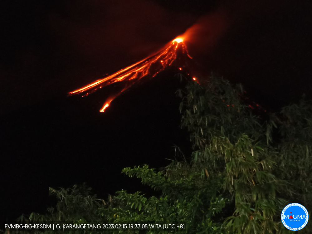
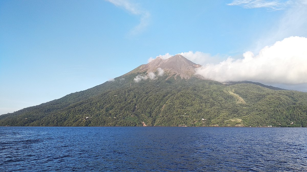
 
Back
Top Bottom