Volcanoes Erupting All Over

Iceland
8 feb 2024

3.jpg

Iceland: Volcanic eruption has subsided considerably

Volcanic eruption weakens - hot water pipe destroyed

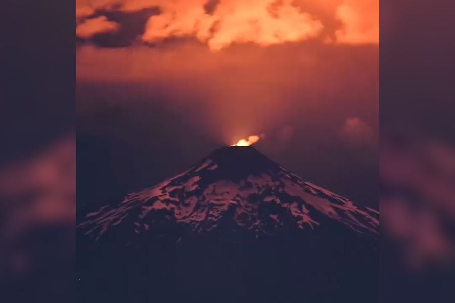
The volcanic eruption in Iceland, which only started this morning at around 6 a.m. UTC, had already lost a lot of its power by the early evening. The livecams currently only show a few spots along the 3 kilometre long fissure where there is lava spattering. In these places, small walls have already formed around the vents. As welcome as the news of the weakening of the eruption may be for the inhabitants of Reykjanes, it was not completely without consequences, because shortly before the lava flow weakened significantly, the lava flow reached the hot water pipe and destroyed it. But at least the workers had managed to bury a 600 metre long temporary pipe in the ground beforehand. They are currently working on connecting this to the hot water circuit, which could take until tomorrow. Until then, many residents of the Reykjanes Peninsula will have no hot water, which is tantamount to the loss of district heating.

2.jpg

This example shows that geothermal energy is not without its drawbacks, because if you live in volcanically active areas, you have to constantly reckon with the loss of the systems. Admittedly, things have gone well for decades now, but what are a few decades on the time scale of a volcano?


1.jpg

After the pipeline was destroyed, the lava flow travelled a few tens of metres before stopping 500 m north-northeast of the Blue Lagoon. Satellite images show that it is a good 4.5 km long and partly crossed the lava field of the eruption on 18 December. This lava flow is the south-western arm of the flow, which roughly diverged in a westerly direction from the eruption fissure and split into two arms at the Stóra-Skógfell hill. The other flowed northeastwards from the rise and travelled a good 1200 metres. There was also a short lava flow to the south of the eruption fissure, but it was not quite as long as the flow of 18 December.

All in all, it was/is a short but violent eruption episode, the most remarkable feature of which was the fast-flowing and very thin lava, which volcanologists are now analysing as quickly as possible. Perhaps there will be new insights into the processes underground that will keep us busy for some time to come.

The eruption is not quite over yet, but the seismicity and tremor have clearly subsided. Considering how short-lived the previous eruptions in the area were, it is rather unlikely that the eruption will intensify again, although it cannot be completely ruled out.


Source article: Vulkane.net
 
Iceland
9 Feb 2024

mbl.is writes that there is no more volcanic activity going on between Sundhnúk and Stóra-Skógfell eruption site.

1470551.jpg

No visible eruption activity

There are no signs of eruptive activity between Sundhnúk and Stóra-Skógfell, which indicates that the eruption is coming to an end.
Eruption turbulence is no longer detected on seismometers. In an announcement from the Icelandic Meteorological Office, it says that no activity was seen when the special force flew a drone over the eruption centers today.


END OF ARTICLE


likewise, visir.is writes the same.

BFE7E3637567F52051742EAFDB3EB28AC1DE9BC5252343FF59007B9608C25A5F.jpg

No signs of eruption activity

No eruptive activity was seen in the eruption area of Reykjanes during a drone flight by the special force that flew over the area a short while ago. This indicates that the eruption is coming to an end.

This is stated in an announcement from the National Weather Service. Eruption turbulence is no longer detected on seismometers.
The Norwegian Meteorological Agency has updated the risk assessment with regard to the development of the activity of the eruption. There have been changes to the risk assessment for individual risks within regions.

The risk of an eruption has decreased, but the risk of gas contamination is still present at the edge of the lava. There is still a risk of lava flow, that risk is related to the possibility that lava rock will break out of the lava rim. The risk of ground rock in cracks and crack movements is still considered high in Grindavík.

END OF SECOND ARTICLE
 

Villarrica Volcano (Chile) on yellow alert

An earthquake was felt during the early hours of Saturday 3 february morning. According to the National Geology and Mining Service (Sernageomin), the monitoring stations installed in the vicinity of the Villarrica Volcano, recorded an earthquake associated with rock fracturing (Volcano-Tectonic).

The earthquake occurred at 2:24 a.m. with a local magnitude of 3.5 degrees.
According to the agency, after the reported event, more earthquakes continue to be registered, but of lesser magnitude.

1707662775015.png

 
Iceland
12 Feb 2024

article from Icelandic Visir.is

Prediction of next eruption: 1 March 2024

Þorvaldur-Þórðarson-is-a-professor-of-volcanology-and-petrology..jpg
Þorvaldur Þórðarson is a professor of volcanology and petrology.

Volcanologist Þorvaldur Þórðarson says it is likely that the next eruption on the Reykjanes Peninsula will be around March 1. It looks like the same pattern that has prevailed will repeat itself. However, an earthquake or other event can always change the situation.

"Production was relatively high at the beginning, but not quite as high as the eruption on December 18, but it lasted longer. So a larger amount of magma came up in the first six hours than it did in eruption 18. The total amount that came up there is perhaps between nine and ten million cubic meters, which is a bit more than in the other eruptions," said volcanologist Þorvaldur Þórðarson in evening news of Station 2.

He believes that it is likely that the pattern of the last few months will continue, that is, after a short eruption, landrising will begin again, which will then end with a magma intrusion and a subsequent eruption.

"Especially because the land boom started right away, and it's at a similar pace as it has been." Which means that the movement of magma from these deeper magma deposits, which are at a depth of ten to fifteen kilometers, is fairly even and has not changed at all," says Þorvaldur.

"The next eruption will probably be on March 1," said Þorvaldur.


The last fires lasted for 30 years

Þorvalður says that we can expect that the Sundhjúka crater series will continue this pattern into the year, and even beyond.

"There can always be an event, an earthquake or something, that changes the way the magma moves. Then the pattern can change. Then this can move to Eldvörpin and later Reykjanesíð. The last time this area was active, the fires lasted for 30 years, or from 1210 to 1240," said Þorvaldur.


END OF ARTICLE
 
Grindavik, Iceland
15 Feb 2024

Several articles from German Vulkan.net are waiting. Here comes one about Grindavik, about larger than anticipated damages in which the town possibly "goes down" like a slow-motion Pompeii due to that the infrastructure in the long run likely will not hold up. (I also read somewhere in an Icelandic article, that the government is offering to buy houses in Grindavik, so that the Grindavikings can start somewhere else.


bild-15.png

Grindavik: the slow decline of an Icelandic town

Is the damage in Grindavik so great that the fight seems in vain?

Before the recent eruptions in Iceland, Grindavik was a small fishing town that was probably only known to die-hard travellers to Iceland. Now the town is increasingly becoming synonymous with a creeping volcanic catastrophe which, unlike Pompeii, does not reduce everything to rubble overnight, but instead continues to gnaw away at the town's infrastructure. Until there is probably no other choice but to abandon the place. An article published today in the online edition of the Icelandic broadcaster RUV reveals that the damage caused by the last eruption a week ago is more extensive than initially realised.

[Drinking water supply affected, too]
Not only was the hot water supply cut, which affected most of the Reykjanes Peninsula, but also the drinking water supply to Grindavik. In addition, an important power cable leading from the Svartsengi geothermal power plant to Grindavik was cut. The RUV article also reveals that many of Grindavik's sewerage pipes are damaged. Extensive renovation work would be necessary before the town can be reoccupied.

Another MBL report states that a large company in Grindavik has apparently put the 22 employees on permanent leave and they now have to receive unemployment benefits. The head of the company is demanding clarity from the government on how things should continue in Grindavik. Other bosses of more than 100 companies in Grindavik also support this demand.

The forecasts for the region are not good.
There is no end in sight to the magmatic activity underground. On the contrary, there are reports in Icelandic FB groups that shortly before the last eruption there was a significant increase in inflation, which has not yet levelled off. However, I can only partially understand this increase based on the GPS measurement data. For me, the course of the count looks similar to that after the intrusion on 10 November. The daily uplift rate is therefore slightly more than 10 mm per day, and the further the ground uplift progresses, the greater the back pressure in the conveyor system, so that the curve will slowly flatten out until another eruption probably occurs. If the reports in the FB groups are correct, the current pause interval may be shorter and another eruption with increased lava output is imminent. Otherwise, we volcano spotters will probably have to wait another 2 to 4 weeks for the next volcanic eruption.

By the way, the GPS measuring station GOHN (Fagradalsfjall) is online again and indicates a weak ground uplift.


Source
END OF ARTICLE
 
Villarica volcano, Chile
16 Feb 2024


Villarrica volcano with increased activity
article by Marc Szeglat

State: Chile | Coordinates: -39.42; -71.93 | Activity: Lavapond

bild02-4.jpg

Chilean volcano emits high thermal radiation

The Villarrica volcano is located in the Chilean region of Los Ríos and has shown an increase in activity in recent days. It manifests itself in high thermal radiation, which is indicated by MIROVA and has an output of 128 MW. The thermal radiation emanates from the main crater. Glowing lava is in the conveyor system and there are strombolian eruptions which, according to SERNAGEOMIN, eject glowing tephra a good 40 metres above crater rim height. Occasionally, glowing cinders also land on the outer flank of the crater cone and fall at a distance of up to 300 metres from the crater rim. For this reason, there is an exclusion zone with a radius of one kilometre around the crater.

The volcanologists report that seismicity is significantly increased. In January, 559 volcanic-tectonic earthquakes were recorded. Most of the tremors were imperceptible, but one VT earthquake had a magnitude of 3.8 and could be felt by residents in the region.

In addition, 12033 long-period earthquakes were detected
which were related to fluid dynamics in the volcanic system and indicate moving magma or volcanic gases. The same causes were found in 2559 tremor phases.

Gas emissions were also increased
in January, an average of 1130 tonnes of sulphur dioxide were emitted per day. The maximum value was 2397 tonnes per day, which was considered anomalous. This figure was topped when more than 2400 tonnes of the volcanic gas were emitted on 6 February. In total, there have been 8 sulphur dioxide anomalies in the atmosphere near the volcano since the beginning of the year, when a particularly large amount of gas was emitted.

Thermal anomalies occurred that triggered alarms 44 times and had a maximum heat flux of 189 MW.

The ground rose slightly due to magma inflation, which resulted in an extension of the monitoring line between two measuring points on the volcano flank. The extension was 7 mm per month.

All in all, it does not look as if Villarrica will calm down again in the foreseeable future. The eruption appears to be largely stable with some fluctuations in intensity, as we are currently seeing.


SOURCE
END OF ARTICLE
 
Grindavik & Eldey, Iceland
16 Feb 2024


Iceland on 16.02.23: Grindavik without hot water
by Marc Szeglat

island-6.jpg

Earthquake off the west coast of Reykjanes - ground uplift continues

In the last 24 hours there has been a swarm earthquake off the west coast of Reykjanes, where many earthquakes manifested themselves in the area of the small island of Eldey. Of course, there were also quakes at Svartsengi, Fagradalsfjall and the other fissure systems on the peninsula. In the Svartsengi area in particular, the earthquakes are coupled with magma intrusion, which further uplifts the ground. The ground uplift follows similar trends and velocities as those observed after the gang rupture on 10 November 2023. In recent days, it has fluctuated between 5 and 10 mm per day.

Model calculations by IMO scientists based on GPS data indicate that the magma accumulation from the end of the eruption on 9 February to 14 February was around 2 million cubic metres. It is estimated that at the beginning of the eruption on 8 February, about 10 million cubic metres of magma flowed from the Svartsengi area towards the Sundhnúkur crater series. If the magma accumulation continues at the same rate, a total of 10 million cubic metres of magma is expected to have accumulated by the end of February or early March. At this point, the probability of a new dyke intrusion and volcanic eruption increases significantly.

Seismic activity has been observed in the western part of Fagradalsfjall since 12 February. Around 80 small earthquakes with a magnitude of 1.5 or less have been recorded. The depth of the earthquakes under the western part of Fagradalsfjall is between 6 and 8 kilometres. The area is continuously monitored, but currently the deformation data shows no signs of magma accumulation.

IMO also released an updated hazard map yesterday, which is valid until 22 February. The main changes include a reduced probability of eruptive fissures opening in all zones. The probability of sinkholes and fault movements is still classified as high in Grindavík.

No warm water in Grindavík
In addition to scientific news, there is also news from Grindavík: Páll Erland, director of HS Veitna, told MBL that less than half of the hot water pumped from Svartsengi to Grindavík reaches the town. Most of it disappears through a leak that has yet to be detected. However, it is assumed that the problem can be solved in the next few days.


Source
END OF ARTICLE
 
Campi Flegrei / Phlegraean Fields, Napoli - Italy
18 Feb 2024


Campi Flegrei with earthquake Mb 3.0 on 17th Feburary 2024
article by Marc Szeglat

bild03-2.jpg


Earthquake Mb 3.0 in the Campi Flegrei - strongest earthquake this year

17 Feb 2024 | Time: 19:22:09 UTC | Location: 40.8377 ; 14.1147 | Depth: 3.0 km | Mb 3.0

Yesterday, another earthquake series manifested itself in the Campi Flegrei caldera in southern Italy. It consisted of 17 tremors, some of which occurred after midnight. The two strongest earth tremors had magnitudes of 3.0 and 2.7. The depths of the earthquakes were given by the INGV as 3.0 and 2.8 kilometres.

However, the epicentres were further apart: while the M 2.7 quake was located in the Gulf of Pozzuoli, the other epicentre was near the city's cemetery, a good 2000 metres northwest of Solfatara. In terms of depth, the two quakes were located at the boundary between the more stable rock layers that retain the melt and the softer deposits with the hydrothermal system. They could therefore be associated with the formation of cracks along fault zones induced by the rising pressure from below. Why the pressure is rising is rarely clearly stated, as the INGV generally speaks of bradyseism.

However, this at best explains the processes in the hydrothermal system of the volcano and not the processes at depths beyond 4-5 kilometres. In my opinion, the phenomenon in Campi Flegrei is ultimately due to a heating magma body. It remains unclear whether melt is accumulating at depths beyond 10 kilometres, or whether there are also melt accumulations at depths of 4-5 kilometres that are increasing in size. In this case, the risk of eruption would increase in proportion to the ground uplift. Even if the ground uplift is not only caused by magma, it is magmatic fluids that push the ground upwards. The risk of phreatic eruptions in the area of the Pisciarelli fumarole and perhaps also in the Solfatara is present and will increase with a further increase in pressure in the system.

The two earth tremors described were the strongest earthquakes this year. The strongest earthquake of the current uplift phase, which began in 2005 and has gained momentum since 2011, occurred on 27 September 2023 and reached Mb 4.2. This earthquake was part of the well-known autumn series, which represented the peak of local seismic activity in recent decades. This was accompanied by accelerated ground uplift. After the series subsided at the end of October, the stresses in the subsurface were significantly reduced until they approached a critical value again in January, at which point the earthquakes started again.

bay.jpg

What to do if the worst comes to the worst?

Should there actually be a major volcanic eruption in the caldera or at Vesuvius - which is likely to happen at some point - chaos is inevitable! My visit to the area last week showed me once again that it is practically impossible to evacuate hundreds of thousands, even millions of people through this maze of streets in a short space of time. Traffic is already gridlocked there at normal rush hour. One option that comes to mind would be to build jetties along the coast and have hundreds of landing craft ready to evacuate people near the coast by sea.

The dilapidated infrastructure of crumbling concrete and motorway access bridges on undersized pillars also do not inspire my confidence in earthquake safety. The expected strong earthquakes in the run-up to a major eruption of the Campi Flegrei alone could create additional problems if collapsed old buildings block the roads. Virtually no building here offers protection from pyroclastic flows. The best option would be to convert the old fortresses, churches and catacombs of Naples into shelters. But that costs money, which is generally not available for disaster control.

The picture from the aircraft taking off in a westerly direction shows the Neapolitan area near the Campi Flegrei.


Source
END OF ARTICLE
 
Eldey, Iceland
18 Feb 2024


Iceland: Is a submarine volcanic eruption imminent?
article by Marc Szeglat

bild03-3.jpg

Series of earthquakes near Eldey - volcanologist fears imminent submarine eruption

Earthquake activity in the area of Iceland's Reykjanes Peninsula has weakened somewhat since yesterday, but further earthquakes have still been detected. A total of 80 quakes have been registered in the last 48 hours, which are listed in the tables of the Icelandic Meteorological Office (IMO). The quakes were distributed along the various fissure systems, with the focus on Krysuvik, Fagradalsfjall and Svartsengi. No new quakes were recorded today at the submarine extensions of the Reykjanes system near Eldey, but this system is again the focus of the report today. The reason for this is an interview by MBL with the volcanologist Þorvaldur Þórðarson, who we now know well, which was published yesterday and focussed on the events at Eldey.

The volcanologist assumes that the earthquake at Eldey could be a sign of an eruption in the coming months. Þorvaldur even fears that there could be a Surtseyan eruption, as he expects an explosive eruption.

Eldey is a good fifteen kilometres southwest of Reykjanes
and there have been numerous earthquakes in the region since the last eruption at Svartsengi on 8 February. The strongest earthquake had a magnitude of 3.2. The volcanologist explains that the earthquakes began at a depth of ten kilometres, but have since moved much closer to the surface and most recently occurred at a depth of four kilometres.

Earthquakes could also be tectonic in nature
"This seismic activity could indicate that magma has accumulated and started to penetrate quite deeply before moving to a shallower depth," says Þorvaldur. "Magma ascent is one interpretation of this, but the other is that it's earthquakes at the plate boundary, and I think we'll just have to wait and see what actually happens."

If an underwater volcanic eruption were to occur off Eldey, it would be an explosive eruption with some ash fall. The strength of the eruption would be similar to the eruptions in Reykjanes in recent years.

"It will never be anything particularly big. It's a rather limited eruption that may cause disturbances in the western part of Suðurnes for maybe a day or two. Then it would just die down like any other eruption and we would move on," says Þorvaldur.

However, there are other volcanologists, such as the equally well-known Haraldur Sigurðsson, who believe that a Surtseyan eruption in the area mentioned could lead to prolonged closures of Keflavík Airport.

"Eldey is a result of the eruptions there. Many believe that the island was formed during an eruption in the 13th century. So it is quite possible that we could have a new island," Þorvaldur tells MBL.

No signs of soil uplift at Eldey so far
I think the statements are very speculative. Only the day before yesterday, IMO specialist Gunnar Ófeigsson stated in an interview that there were no signs of ground heave in the Eldey area. Although it cannot be ruled out with certainty that there are no bottom formations on the seabed, the seismicity is still far weaker than what we have seen in the early stages of magma intrusions on Reykjanes so far. The magma-induced swarm earthquakes at Grimsey were also much stronger at the TFZ. Certainly, in the course of the new activity on Reykjanes, a submarine eruption may occur again at Eldey, but I do not expect this in the medium term.

Incidentally, the ground uplift at Svartsengi continues even without strong earthquakes, which indicates that a stable magma channel has formed along which the melt rises from greater depths. The uplift rate is between 5 and 10 mm per day. It will only be a few days before the ground uplift level is reached as it was before the last eruption. In the meantime, there are also clear signs of a new uplift at Fagradalsfjall. It has reached 30 mm since the last week of January.


Source
END OF ARTICLE
 
Back
Top Bottom