Volcanoes Erupting All Over

Grindavík, Iceland
16 Jan 2024

This time an article from German Vulkane.net - translated into English.


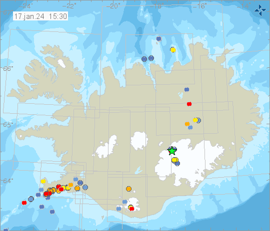
Iceland: New hazard map on 16 Jan 2024

After the eruption is before the eruption - New hazard map from IMO

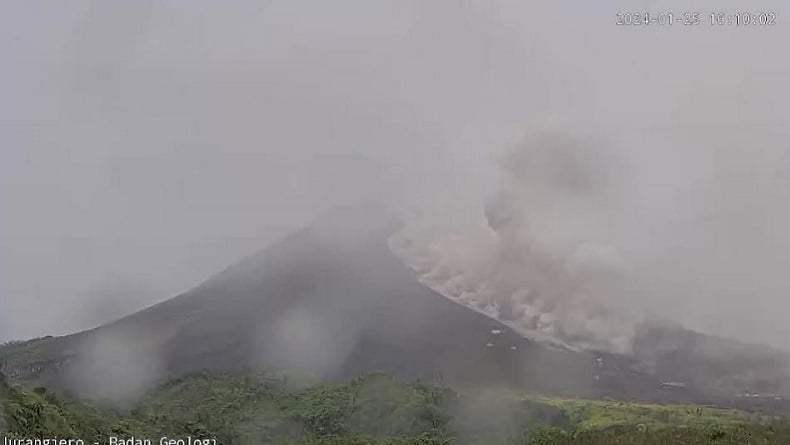
It looks as if the eruption that began on the Icelandic peninsula of Reykjanes on Sunday is already over. But the short-lived episode brought little relief to the subsurface, so it is expected that the superficial calm will not last long.


bild02-Mittel.jpg


Yesterday evening, IMO issued an unusually long statement.
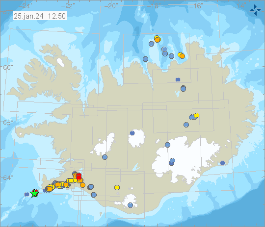
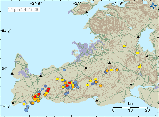
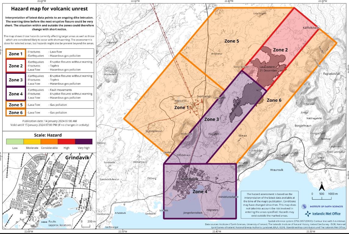
It states that the threat situation has been reassessed and a map has been released. It shows that Grindavik is now back in the area with the highest danger level. In the course of the eruption, the subsurface moved particularly strongly here, and while the underground magma movements along the newly intruded magmatic vein had come to a standstill everywhere yesterday evening, magma movements were still detected under Grindavik.

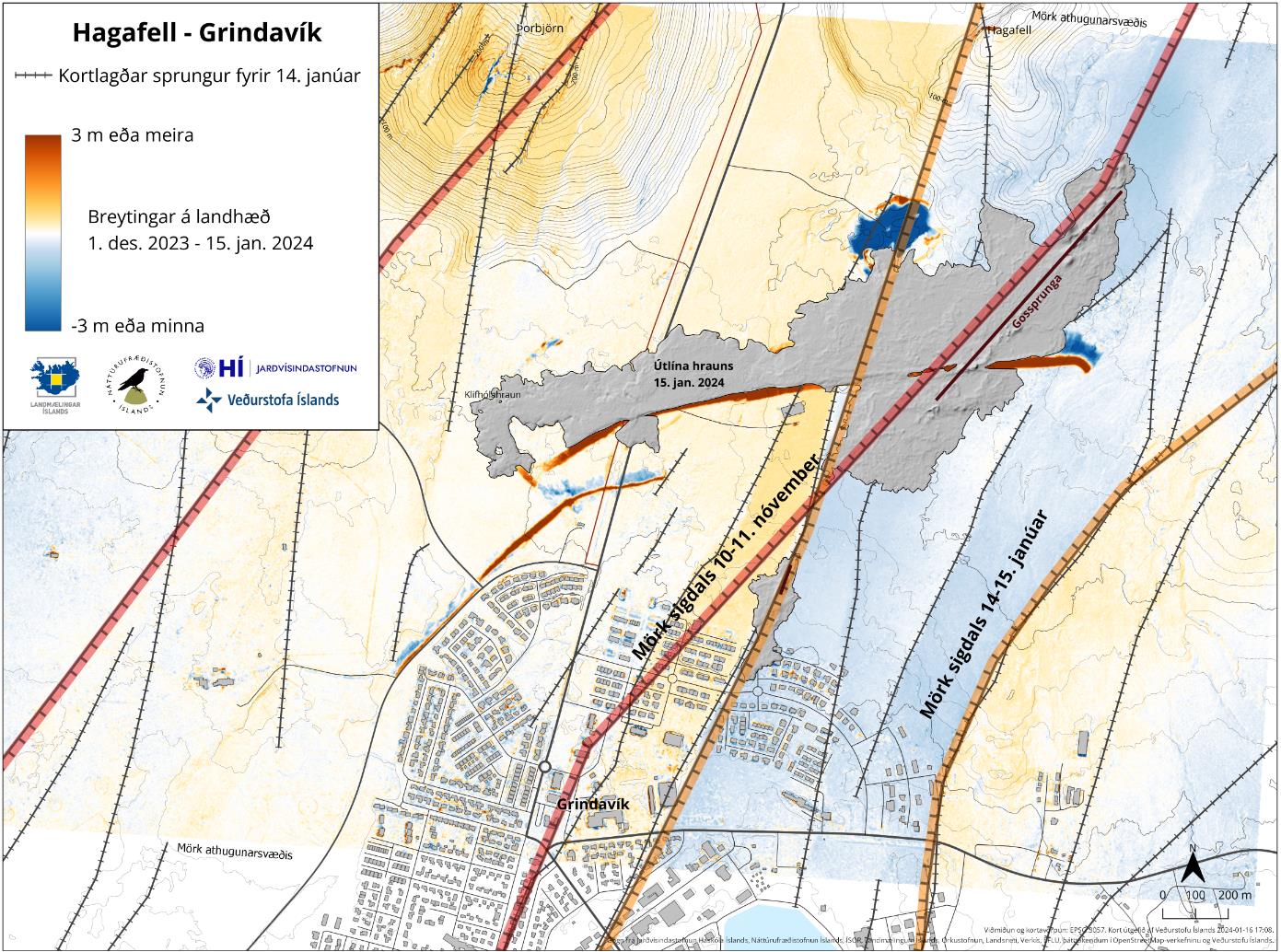
During dyke formation and eruption, the ground in Grindavik sank by up to 140 cm. New fissures opened up and existing ones enlarged. I think it is possible that not only fresh melt was erupted from the fissure on the edge of the town during the eruption, but also melt that had already intruded there on 10 November. Perhaps analyses of lava samples will provide more precise information in this regard.


bild01-Mittel.jpg

A map from IMO
also shows that the dam apparently functioned and diverted the main lava flow away from the city. If this lava flow had marched through Grindavik, the discussions about the fate of the settlement would probably have largely ceased. Personally, I think it is already sealed now, because even if the houses are not eaten away by new lava flows, the subsoil is so unstable that it is no longer possible to live here permanently with a clear conscience.

Countless boreholes would have to be sunk to uncover hidden cavities, so it would seem more sensible to rebuild the city elsewhere or abandon it altogether. Of course, if safety standards are disregarded, it might be possible to live there again in a few years' time.

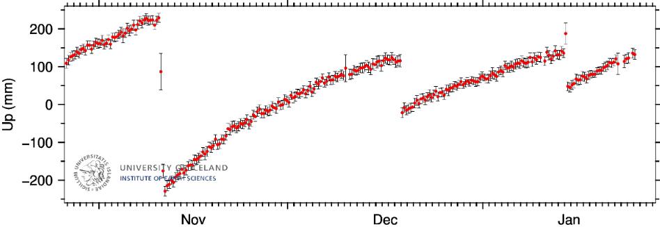
At the moment, however, it does not look like the general situation will ease in the long term, as the ground at Svartsengi continues to heave and magma is rising from the depths. In contrast to the previous two events, the ground there has hardly subsided. Either the intrusion of the new vein did not originate from here or it was too small to have lowered the ground significantly.


📌 Grindavík: the city continues to deform!

The eruption of Grindavík continues to weaken steadily and only a very small portion of the main fracture to the north of the protective barriers remains active at this time. Its end seems near, but the effects it is causing on the surrounding environment are far from over. During the afternoon, the Icelandic authorities entered Grindavík to assess the changes that the city has undergone as a result of this new dyke, which has also affected the city itself and deformed it very significantly.

Somewhat like what had already happened on 10 November, over the past 48 hours the ground in Grindavík has undergone a major deformation that has caused large cracks to open up in several areas of the city. The cracks that had formed two months ago and had been partially repaired in some cases have reopened and widened, causing new damage to roads and water and heating pipes (which remain out of use). A rescuer who was carrying out one of these inspections saw the ground suddenly collapse under his feet, fortunately without consequences, unlike the man who had fallen into one of these cracks before the eruption began (and was never found).

418235168_805089601631460_5029336704189828759_n.jpg

418262525_805089641631456_2306415981832015173_n.jpg
419493426_805089701631450_8602340527521982684_n.jpg

END OF ARTICLE
 
Grindavík, Iceland
17 Jan 2024

A new rift/fault appeared in Grindavík while strong deformations are being observed. German Vulkane.net reported with following article (out of two).


bild01-10.jpg

Strong ground deformations at Svartsengi and Grindavik - New rift formed

While the earthquake activity along the magmatic passage has decreased somewhat, the ground uplift at Svartsengi remains high and has even increased in the last few hours. Two days after the magma tunnel was formed, the gauge should have started to show a decrease if the magma accumulation had stopped. This is not the case and it is therefore clear that magma continues to accumulate. The exact rate is not so easy to read from the various graphs, but I would estimate it at 8 to 10 mm per day.

It is particularly high at the NORV and HS02 measuring stations. It looks as if the main magma upwelling channel has shifted slightly to the west. This is also the conclusion reached by the calculation models of the Icelandic geoscientists, who added another report yesterday evening. According to this, the magma that formed the new magmatic passage migrated eastwards from Svartsengi and then spread from Stóra Skógsfell to the south under Grindavík.

A new rift is also forming
similar to the one we saw on 10 November. However, there were no strong earthquakes with magnitudes over 4.

Nevertheless, there were strong ground movements not only in Grindavík, but also along the section of the rift further north: the intrusion of the passage stretched the earth's surface and then subsided over the passage, resulting in an elongated depression. This is between 800 and 1000 metres wide and up to 30 cm deep, although it was reported yesterday that the ground in Grindavik has sunk up to 140 cm in places, which may also have been caused by the magma ejection.

Initial analyses of the lava samples showed that it was basically a tholeiitic basalt magma again, as was already erupted at Fagradalsfjall, with the difference that it was more differentiated and was probably stored in the magma reservoir for longer. The melt that was ejected from the southernmost fissure near Grindavik was particularly undersaturated with magnesium and could have been even older than the material from the main fissure.

Perhaps magma that had accumulated there a long time ago was also ejected here. This would explain the particularly strong subsidence and also contradict the assumption that the melt in the veins cools down within a few days to such an extent that it is no longer free-flowing.

Incidentally, bathing in the Blue Lagoon has been suspended again. A new decision will be made tomorrow as to how long the closure will last.


END OF ARTICLE
 
Bardarbunga Volcano + Grindavík, Iceland
17 Jan 2024


Noticeable earthquake at Bardarbunga - little hope for Grindavik

17 Jan 2024
| Time: 14:14:44 UTC | Location: 64.626 ; -17.464 | Depth: 2.1 km | Mb 4.1

island-4.png

Bardarbunga Volcano

This afternoon, the Icelandic glacier volcano Bardarbunga was shaken by an earthquake of magnitude 4.1. Earthquakes of this magnitude are perceptible. However, due to the remoteness of the volcano, no perceptions have been reported. The hypocentre was located at a depth of 2 km. Some earth tremors also occurred in the area of the neighbouring Grimsvötn volcano, which was in the headlines last week due to a glacier run. The peak of the glacier flow was reached on Sunday, but reports of this were lost in the hustle and bustle surrounding the eruption at Grindavik.

Speaking of Grindavik, earthquakes continue to occur here and the IMO tables show 148 tremors in the last 48 hours. As not all earthquakes are recorded automatically, there could have been more tremors.

Grindavik uninhabitable

This morning there was another expert conference to which the citizens of Grindavik were also invited. Geophysics professor Magnús Tumi Guðmundsson announced at the conference that there was no good news for Grindavik. In his opinion, the town would be uninhabitable for the time being. There is no end in sight to the magmatic activity and ground formations. In fact, the activity could continue for months or years. Magnús said that there was complete uncertainty about when and when decisions could be made about what the future holds for the city's inhabitants. It would therefore be better to think in the long term than just consider the next few weeks. In short, the geophysicist indicated that the Grindaviknigs would be better off looking for a new place to live permanently.

It was only shortly before Christmas that the citizens were left free to decide for themselves whether they wanted to return to Grindavik. However, the reason for this was not a reduced danger for the people, but the Icelandic legal situation, according to which evacuations are limited in time. The question is whether the laws have changed in the meantime? As far as I know, they haven't and so it could be the case again in a few weeks' time that the Grindavikings have to be allowed to return to their homes.


END OF ARTICLE
 
Grindavík, Iceland
18 Jan 2024

Vulkane.net had another article on the situation at Grindavík today. I also picked up from the Icelandic newspapers, that the ground under Svartsengi (powerplant) continues to rise, and that the nearby Blue Lagoon is closed for an unknown time in the future


Iceland: Magma lies flat under Grindavik

Magma in fissures under Grindavik - gas contamination discovered in drinking water wells

bild02-Mittel-2.png

Seismic activity on the Reykjanes Peninsula was low overnight. At least the IMO Shakemap shows only a few earthquakes so far, which may also be due to a lack of updates to the system. The ground uplift continues and initial measurements after the eruption suggest a somewhat stronger underground magma inflow than was the case before. However, IMO wrote in its latest statement last night that it is still too early to give exact values. Probably because the ground can also move as a result of the eruption and the associated trenching above the new dyke. If I interpolate the current measured values, then in less than 2 weeks the ground uplift level will be the same as before the eruption and the game can start all over again.


bild01-Mittel-3.jpg

At the southern end of the new magmatic vent
lava appears to be close to the earth's surface and could erupt at any time regardless of a new intrusion. The southern end of the vein is unfortunately located under Grindavik. New drone images taken with a thermal imaging camera yesterday showed heat signatures along cracks in the city. The heat flow from the ground appears to be very high.

Another problem in Grindavik is that contamination has been discovered
in the drinking water wells, most likely caused by magmatic fluids. The wells are connected to the town's water supply, which could cause further problems. The wells are not yet monitored by IMO. Other institutes have been using drinking water wells for some time to determine whether there are geochemical changes in the water that would allow conclusions to be drawn about any rising magma.

One example is the INGV, which regularly analyses water samples from the wells on Vulcano. A change in conductivity or a change in the ratio of helium isotopes are regarded as early indicators of rising melt. The concentration of carbon dioxide in the water also provides corresponding indications. In Grindavik, however, the contamination is likely to be less subtle, as melt is definitely close to the surface and can also directly contaminate groundwater aquifers.


END OF ARTICLE
 

Merapi Launches Hot Clouds, Boyolali and Klaten Are Flooded with Ash Rain​


Mount Merapi on the border of Central Java and Yogyakarta Special Region has experienced four times of pyroclastic flows on Sunday (21/1/2024) from morning until afternoon. As a result of the pyroclastic flows that occurred on Sunday afternoon, there was ash rain in Boyolali and Klaten regencies, Central Java.

"Based on BPBD Klaten's observation, there was no panic among residents or visitors at the tourist sites affected by the ash rain. The ash rain also did not have a significant impact as there was rain right after it, which swept away the volcanic ash," said Mohamed Chomsul the Head of the Emergency Response Unit of the Regional Disaster Management Agency (BPBD) in Central Java.


Huge erupt at the Merapi volcano in the central Java Province of Indonesia 🇮🇩 (21.01.2024)

Massive valcano erupt on Mount Merapi in the central Java Province, Indonesia 🇮🇩 (21.01.2024)
 
Grindavík / Svartsengi, Iceland
25 Jan 2024

The ground over Svartsengi continues to rise and has reached record levels. Apparently the Grindavikings can soon return to their town. (However, numerous more hidden cracks and caves have been discovered earlier, in parts of the town. The article doesn't mention anything about those).


Soil uplift at Svartsengi at its highest level - Grindaviknigs can return soon

bild03.png

Despite all the prophecies of doom
that were spread on social media yesterday that the ground uplift at Svartsengi had stopped, it continues unabated and has even reached a record level of around 50 cm within 10 weeks. This means that the ground is rising much faster than was the case at Askja, for example. These prophecies of doom were caused by short-term fluctuations in measurements, as we have often seen in recent weeks. Perhaps the ground uplift also stalled for a short time. If that was the case, it then accelerated again. Not only at Svartsengi is the ground uplift high, but also at other measuring stations. At the SKSH station, for example, the ground uplift will soon return to the level seen before the last eruption. Unlike directly at Svartsengi, the ground here had sunk by almost 100 mm on 14 January.

island-7.png

Earthquake activity on Reykjanes remains high
and a magnitude 3.0 quake occurred off the southwestern tip of the peninsula at noon today, 2.6 km northwest of Eldey. In fact, all 5 fissure systems of Reykjanes are seismically active right now, which we actually last saw in this way at the very beginning of the activity on Reykjanes. This does not mean that eruptions are to be expected everywhere, but it does show the great potential for unrest in the area near the capital. Perhaps the tensions in Svartsengi are now so strong due to the large ground deformation that they are triggering relaxation earthquakes in other systems.

The police chief and mayor of Grindavik are unimpressed by these events
and told RUV that it should be possible for the residents of Grindavik to return to their homes from Friday: The supply of hot water and electricity had been largely restored and they were working on new escape routes. The initial aim is probably to allow access again during the day. Nevertheless, the next outbreak could start at any time. It is also impossible to predict where the next eruption will take place, although it is most likely that fissures will form again along one of the two new rifts.


END OF ARTICLE
 
Svartsengi, Iceland
26 Jan 2024


Ground uplift higher than before the last eruption

bild02-5.png

In the Svartsengi area of Iceland's Reykjanes Peninsula
ground uplift is high over a wide area and is higher than before the eruption on 14 January. This is the result of an update published yesterday by IMO scientists. According to the update, the ground at Svartsengi is uplifting at an average rate of 8 mm per day. Before the eruption, this value was 5 mm. Today, the SKSH measuring station has also reached parity with the ground uplift level before the last eruption. This means that the probability of eruption is increasing again.

Although a new volcanic eruption can be expected at any time
the IMO's disaster management organisation has lowered the hazard level for the region slightly and published a new hazard map. Externally, it hardly differs from the previous map, with the exception that the colour coding of the hazard zones is different. Nevertheless, IMO emphasises that the hazard potential generally remains high. In Grindavik in particular, there is a threat of further earth movements.

On the website of the Icelandic Meteorological Authority, it can be read today that earthquake activity along the magmatic intrusions has decreased significantly in recent days. The magma movement in the dykes has almost come to a standstill. The magma, which rises under Svartsengi and accumulates in a magma body at a depth of around 5 kilometres, completes its ascent virtually silently and hardly triggers any earthquakes. This is a sign that the ascent paths are clear and the molten mass can rise unhindered.

The battle for Grindavik continues
Geophysicist Benedikt Sigurðsson told the television station RUV that nothing could stop this magma from rising. He expects the next volcanic eruption in 3-4 weeks and is of the opinion that one should expect an eruption every 5 to 6 weeks in the near future. In the meantime, work continues on the fortifications around Grindavik. Apparently the Icelanders are not prepared to give up the town without a fight. And so we experience another chapter of man versus lava.


END OF ARTICLE
 
Phlegraean Fields / Campi Flegrei, Neaples - Italy
25 Jan 2024


bild-27-1.jpg

Further increase in seismicity in the Campi Flegrei

For the first time since the seismic crisis in October, I can again report on something like an earthquake swarm that has been occurring in the area of the southern Italian Caldera volcano since yesterday. The INGV's seismic network registered 23 tremors. The strongest single earthquake measured Mb 2.0 and had a hypocentre at a depth of 2.5 km. It was therefore quite far down in the area of the hydrothermal system. A rupture may have occurred in one of the surface layers. The epicentre was in the north-east of the caldera. Most of the other quakes manifested themselves in the Solfatara area. I can well imagine that the ground uplift will continue to accelerate over the next few weeks. Most recently it was 10 mm per month.

Vesuvius earthquake
Interestingly, the neighbouring volcano Vesuvius is also quite lively seismically: 36 weak tremors were detected this month. The quakes have magnitudes in the microseismicity range and are located at a depth of a few hundred metres. Is this due to the fact that several members of the Volcanological Society are currently travelling there? Very probably not! Nevertheless, I will also be visiting the volcano next month.


bild02-Mittel-6.png

More tremors under Vulcano
It is not yet clear whether I will be travelling to Vulcano again in the foreseeable future. But there are more tremors here too. Activity there had only decreased over the course of last year, but now it seems to be increasing again. On the shakemap, in addition to the cluster that I reported on last week, you can see two new weak tremors that manifested themselves directly under the island. This is not yet a reason for renewed alarmism, which was primarily caused by increased gas concentrations in the harbour area, but the tremors show that this is a potentially active volcano with a magma body slumbering beneath it.


END OF ARTICLE
 
Santorini, Greece
25 Jan 2024


Researchers discover deposit of a supervolcano eruption near Santorini

Researchers have discovered traces of what is probably the largest eruption in the history of the Aegean. It is known as the "Archaeos eruption" and is impressive in size. The undersea volcanic eruption occurred in the Santorini volcanic field and left behind massive pumice deposits up to 150 metres thick on the seabed. This discovery is based on core analyses carried out by geologists led by Tim Druitt from the University of Clermont-Auvergne, who drilled twelve boreholes in the Christiana-Santorin-Kolumbo volcanic field to study volcanic deposits from the last 23 million years.

43247_2023_1171_Fig1_HTML.png.jpg

Location of the borings in the volcanic field. © Druitt et al./ Communications Earth & Environment


The results show that the Archaeos eruption occurred about 520,000 years ago and originated from a submerged volcano of the Santorini complex. The amount of volcanic material ejected during this event was impressive. The tuff deposit had a volume of more than 90 cubic kilometres and a thickness of up to 150 metres. This exceeds the deposits of the famous Minoan eruption by a factor of six and those of the recent Hunga Tonga eruption of January 2022 by a factor of ten.

bild-26.jpg

The reconstructed eruption dynamics indicate
that gas-rich magma shot out of the undersea volcanic vent at high speed and mixed with the partially vaporising water. This led to the formation of a hot mixture of gas, volcanic ash and pumice lapilli, which spread out as pyroclastic flows. These dense flows reached a length of up to 70 kilometres and slid across the sea.

The discovery also has implications for understanding the South Aegean volcanic arc
by indicating a greater capacity for highly hazardous submarine eruptions. The existence of a large buried submarine caldera beneath the modern volcanic field is implied, and the eruptive history of the Christiana-Santorini-Kolumbo volcanic field is extended further into the past.

Although these results point to an explosive past, the researchers emphasise that it is extremely unlikely that the volcanic field will experience a similarly massive eruption in the foreseeable future. Nevertheless, such findings help to better understand the behaviour and dangers of such volcanoes and can play a role in predicting future activity.

As unsettling as the idea of another European supervolcano may be, the research also shows that not every eruption of such a caldera system has to end in a supervolcano eruption. I am thinking in particular of the current events in the Campi Flegrei caldera in southern Italy, which has become more turbulent again in recent days.


END OF ARTICLE
 
Merapi, Indonesia
25 Jan 2024


Several pyroclastic flows erupted at Merapi

bild01-28.jpg

During the afternoon, three pyroclastic flows erupted
from the Indonesian volcano Merapi on Java. This is according to notes from the Indonesian Volcanological Service (VSI). According to the notes, the density currents manifested at 16:06, 16:09 and 16:13. All times are in local time WIB. The outflows generated seismic tremors that were registered by the network at the volcano. The maximum amplitude was 29 mm and the largest pyroclastic flow travelled for 151 seconds.

The maximum slip distance was 1,500 metres
to the southwest and towards Kali Bebeng. I know the location, which was already in the firing range of pyroclastic flows in the noughties. It was largely destroyed in the 2010 eruption.

The dense flows produced clouds of volcanic ash that rose to an altitude of 3,400 metres and were blown eastwards. There are no reports of ash rain, so it can be assumed that the ash clouds rained down over uninhabited areas.

Volcanic seismicity is otherwise dominated by debris avalanches, while earthquakes caused by underground magma movements are rarer than was the case just a few weeks ago. Nevertheless, 10 hybrid earthquakes were recorded within 6 hours. Representatives of the BPPTKG spoke out and were quoted in the local media. They called on people to stay away from the danger zones and to respect the exclusion zones.

The current potential danger from debris avalanches
and density currents in the south-southwest sector is greatest in the Boyong Bedog, Krasak and Bebeng valleys. The exclusion zone is 5-7 kilometres. A stay in the south-eastern sector of the Merapis with the rivers Woro and Gendol is also dangerous. The exclusion zone here is 3-5 kilometres. In the river valleys, there is also a risk of lahars occurring during heavy rainfall. The mudslides can dam up rivers and jump over bridges and should be approached with extreme caution.


421761157_18319247425138395_7804725022810415979_n.jpg
By the way, our club member Andy was out and about on Merapi on the last night of the full moon and took this great photo.

END OF ARTICLE
 
Grindavík-Svartsengi + Krýsuvík fissure system, Iceland
24 Jan 2024


Iceland: Krýsuvík becomes more active

Earthquakes and ground uplift continue - Krýsuvík fissure system awakens

Not much has changed on Iceland's Reykjanes Peninsula since my last update: Ground uplift and earthquake activity continue, but seem to be weakening or shifting somewhat. IMO reported this morning that there were about 30 tremors at Dyke yesterday. Only 7 quakes were detected there at night. However, if you look at the Shakemap, you don't get the impression that there are significantly fewer earthquakes than in recent weeks. In particular, there is an increase in earthquake activity in the Krýsuvík fissure system, which some authors include Fagradalsfjall in.

island-6.png

In an MBL interview, volcanologist Ármann Höskuldsson commented that he sees clear signs that the Krýsuvík system is becoming more active and reckons that it is preparing for an eruption. The explosive aspect is that the north-eastern foothills of the fissures extend right up to the gates of the capital: This system was also responsible for the last eruptions near Reykjavik, although this was several centuries ago. The volcanologist cited the region's earthquake activity and a swelling and subsiding of the ground caused by the movement of magmatic fluids as signs of the awakening. However, Ármann made the caveat that it was not possible to say when an eruption might occur. It could happen soon or it could take decades.

bild02-4.png

Ármann Höskuldsson already made statements at MBL yesterday. In one, he virtually confirmed what I have suspected for some time: that the magma storage system in the Svartsengi area is much more complex than was initially thought. The processes can no longer be explained by the formation of a sill under Svartsengi, because the melt spreads underground in too many directions and at too different speeds for that. The fact that the most recent eruption did not result in a clear subsidence at Svartsengi, but instead caused other areas to sink, also shows that the melt intruded from a branched storage system into the new magmatic passage.

END OF ARTICLE
 
Reykjanes, Iceland
8 Feb 2024


A NEW ERUPTION just has started (1 hour ago)

bild02-2.jpg

German Vulkane.net writes following:

New eruption on Reykjanes has begun - warning time was short

This morning, shortly after 6 a.m. UTC, the expected volcanic eruption began on the Icelandic peninsula of Reykjanes. After a brief seismic crisis lasting about 30 minutes, which manifested itself at Sýlingarfell, an eruption fissure a good 3 kilometres long opened in the area of the eruption of 18 December 2023. The fissure strikes roughly north-south and runs from Sundhnúk in the south to the eastern end of Stóra-Scógfel. The lava flows to the sides of the fissure, i.e. in an east-west direction. Although lava fountains are rising along the fissure, the flow rate appears to be lower than during the eruption on 18 December. Perhaps it will last longer in return!

bild-Mittel-11.jpg

In the first few minutes, the fissure extended both to the north and to the south.

The ground uplift already started to rise slightly again last night, after hardly any uplift in the previous 36 hours. I speculated that the elastic limit of the rock above the magma body may have been reached and that the back pressure in the conveyor system was too great to allow further magma to rise unhindered. This could indeed have been the case. Now we have to wait for the next measurements to see whether and by how much the ground has subsided.

bild-10.jpg

Grindavik not yet in immediate danger

The volcanic eruption can be seen very clearly via the various webcams on the hills around Grindavik. There is currently no immediate threat to the town, as the eruption is likely to take place north of the watershed again. However, if the eruption continues for several days, the main road leading into Grindavik will be at risk.

The current events show how quickly an eruption can develop and how little warning time there is to carry out any evacuations. I am thinking in particular of the Blue Lagoon, which is not far from the fissure. Until now, the people in charge there have always assumed that they have at least 90 minutes' warning time between the onset of the swarm earthquakes and the start of the eruption. Far from it!


END OF ARTICLE


(YT) Lifecam of the eruption link below (you can see how it started, and how quickly the rift opened)

Eldgosa- og náttúruvárvakt Víkurfrétta

 
Last edited:
Iceland. Gathering info
8 feb 2024

Visir.is wrote in their first article following:

09C8B612A1915021BCD79BD0C1A8E845ED85006787A67EEEE02E47B0356FA0C1.jpg

Located from Sundhnúk in the south to the eastern end of Stóra-Scógfell

According to the first reports from the Coast Guard's surveillance flight, the eruption is in the same areas that erupted last December 18.

This is reported in an updated post on the website of the Icelandic Meteorological Office. It says that the crack is about three kilometers long, running from Sundhnúk in the south to the eastern end of Stóra-Scógfell. Lava flowed mostly to the west at this stage.

Sigríður Kristjánsdóttir, a natural hazard expert at the Icelandic Meteorological Agency, says that the eruption is now in a similar place to the last one. The lava flowed a little more to the west.

"The crack seems to be about three kilometers long and it seems that the lava flow now is less than last time."


It is possible that lava will start to flow towards the gardens at Svartsengi

“It looked very similar to the eruption that started on December 18. The fissure is a little shorter than then, it is about three kilometers and the lava flow is very similar to that of December 18. The lead up to this eruption was very short and it flows east and west from the crater. It will probably flow north along Stóra-Scógafell," says Björn Oddsson, a geophysicist at the Public Safety Department of the National Police Commissioner, in an interview with a news agency.

It can be assumed that the eruption behaves similarly to the last one - Vísir

“It looked very similar to the eruption that started on December 18. The fissure is a little shorter than then, it is about three kilometers and the lava flow is very similar to that of December 18. The lead up to this eruption was very short and it flows east and west from the crater. It will probably flow north along Stóra-Scógafell," says Björn Oddsson, a geophysicist at the Public Safety Department of the National Police Commissioner, in an interview with a news agency.

Little facebook video, 35s, showing how the eruption looks like from a driving car's view.


Another low light video (very cool !!) but shown via visir.is, showing the very first glimpse when the eruption started at 06.02 local Icelandic time and then unfolded into great fountains of lava

1.jpg
2.jpg
 
Iceland: Lava flows towards geothermal power plant

1.jpg


Lava flow on Reykjanes faster than initially thought - Blue Lagoon and geothermal power plant at risk

The volcanic eruption on Iceland is in full swing and the lava is flowing much faster than expected on site this morning. Initially, the lava flowed perpendicular to the eruption fissure, which runs roughly north-south, before changing direction. In the meantime, the lava flow has crossed the main road Grindavíkurveg and is heading towards the area of the geothermal power plant and the Blue Lagoon. In less than three hours, the lava flow could reach the hot water wells and pipes that supply Suðurnes (most of Reykjanes except the capital) with hot water. This could jeopardise the hot water supply in large parts of Reykjanes, and that in the middle of winter!

Víðir Reynisson, director of the disaster management department, admitted to the Icelandic media that they are practically powerless to do anything about the looming disaster. Although attempts have been made to quickly cover an above-ground hot water pipe with soil, it is uncertain whether there is enough time left to effectively protect the pipe. "It doesn't look good at the moment, but everything is being done to prevent an emergency," said Víðir Reynisson.

The director called on people to save water and announced that large industrial consumers would be disconnected from the water supply so that at least private homes could still be heated to some extent. If the hot water pipe is destroyed, it can take up to three days to restore the hot water supply.


2.jpg

But the situation is not completely hopeless, because if you look at the live streams, you can see that the lava ejection from the fissure has already slowed down somewhat. In the meantime, the first parts of the fissure are beginning to become inactive and there are interruptions in the long series of lava fountains. But whether the activity will subside quickly enough to save the water pipes and the borehole is another question.

END OF ARTICLE

Source: Article by Vulkane.net by Marc Szeglat


mbl.is

1470148.jpg

1470106.jpg
Lava overflowed Grindavíkurveg earlier today. mbl.is/Kristinn Magnússon

3mp.jpg

1470193.jpg

The eruption has changed

There has been a change in the eruption that erupted this morning between Sundhnúk and Stóra-Scógfell. In an announcement from the Icelandic Meteorological Office, it is likely that magma is coming into contact with groundwater. This will result in a slight explosion where a white steam plume mixes with a dark ash plume. It seems that the ash does not reach far from the crater as it stands now. The plume moves to the southwest.

Reduces the effectiveness of the soda (lava ?)

The power of the eruption has decreased, says the announcement. New eruptions mainly in three places on the fissure.
This is not unlike what was seen in the December 18 eruption, when activity shifted to individual craters a few hours after eruption.
Seismic activity has also decreased since this morning.
 
Last edited:
Back
Top Bottom