From midnight to this morning, large-scale sprites and elves appeared one after another. A wide-angle camera from Hiratsuka's home to the south and southeast of the sprite that appeared from 1:00 to 4:00 on January 29, 2021. Sprites are lightning strikes into space that occur with lightning strikes.
You are using an out of date browser. It may not display this or other websites correctly.
You should upgrade or use an alternative browser.
You should upgrade or use an alternative browser.
Crazy Storm Weather and Lightning - Global
- Thread starter mabar
- Start date
Natural disasters worldwide resulted in tens of billions of dollars in damage in 2020, according to catastrophe bonds firm Artemis, citing a new report from German reinsurer Munich Re.
From Yale Climate Connections:
Earth was besieged by a record 50 billion-dollar weather disasters in 2020, the most such disasters ever recorded after adjusting for inflation, said insurance broker Aon (formerly called Aon Benfield) in its annual report issued January 25. The previous record was 46 billion-dollar weather disasters, set in 2010 and 2011. The annual average of billion-dollar weather disasters since records began in 1990 is 29.

...Those numbers make 2020 the fifth costliest year on record for weather-related disasters.
...More than 80% of the severe weather damage occurred in the U.S. in 2020, including the costliest severe weather outbreak in world history, according to Aon: an August 2020 event that featured a violent derecho in the U.S. midwest that caused $11 billion of the $12.6 billion in damage of the outbreak, the balance caused by tornadoes, hail, and other severe thunderstorms.
The most expensive disaster of 2020 was the summer monsoon flooding in China, which caused $35 billion in damage.
The entire article with related comments can be found on sott.net:
World hammered by record 50 billion-dollar weather disasters in 2020
From Cs session 9 May 2020:
Q: (L) Alright. So, we didn't have a session in April because I swear... It was just too fascinating to watch what was going on in the world. Just unbelievable! To watch people going completely insane and... And the lies! Oh my god, the LIES! It's like we are swimming in a sea of lies. All the media, all the governing bodies... I don't think there are any exceptions for any of them. We used to - and possibly still do - admire Putin and Russia, but he's joined the whole gang, too. There are just very few that have not been completely taken in by the lies. It's been a roller coaster of a month.
A: Indeed, but it will get even more interesting before it is all over.
Q: (Artemis) "Over" as in the planet explodes, or what kind of "over" do you mean here?
A: Weather will play a more prominent role next.
I reckon that is another hit for the Cs!
From USA Today:
Last year the world was hammered by a record 50 billion-dollar weather disasters.
It is becoming more apparent that erratic seasons, extreme weather patterns and natural disasters are increasing, which is not a consequence of "human-caused climate change" (formerly known as man-made 'global warming') as parroted relentlessly by the MSM, but part of a natural cycle.
See also:
Fierce hail storms batter Texas, Oklahoma: 'Billion-dollar' damage likely from 'gargantuan' hail
Residents in Texas and Oklahoma were recovering Thursday after hail as large as softballs battered portions of the states a day earlier, leaving behind shattered windows on cars and in homes.
In Oklahoma, at least one injury was reported when large hail hit Norman and surrounding areas Wednesday evening, officials said. A National Weather Service spotter reported hail in excess of 3 inches in diameter around 9 p.m. in the Norman area.
A wind gust of 69 mph was measured in the area at 9 p.m. as the storm pushed through.
In all there were 38 reports of severe hail across the two states, according to the Storm Prediction Center.
"Yesterday was certainly a billion-dollar hail loss day across the U.S.," Northern Illinois University meteorologist Victor Gensini said. "San Antonio and Fort Worth, Texas - along with Norman - were all impacted with large to significant hail. In addition, there was one gargantuan (4 inch) hail report near Hondo, Texas."
CNN senior meteorologist Dave Hennen said that it would be the second billion-dollar disaster this year in Texas, following the extreme Arctic outbreak back in February.
Hail makes up the highest number of insurance claims each year and can exceed $10 billion in losses annually, according to the Weather Channel.
The storms were part of a sprawling system that brought severe weather and heavy rain to much of the southern and central Plains. In addition to large hail, storms also produced damaging winds and a few possible tornadoes, CNN said.
Contributing: The Oklahoman
Last year the world was hammered by a record 50 billion-dollar weather disasters.
It is becoming more apparent that erratic seasons, extreme weather patterns and natural disasters are increasing, which is not a consequence of "human-caused climate change" (formerly known as man-made 'global warming') as parroted relentlessly by the MSM, but part of a natural cycle.
See also:
- Over two million Texans lose power during winter storm Uri, rolling blackouts implemented as record cold strains grid to maximum
- Spain breaks coldest temperature record AGAIN at -35.8C, just a day after new one set
- Volcanoes, Earthquakes And The 3,600 Year Comet Cycle
- Global temp plunges 0.26C in a month: "The next ice age has just started"
- Adapt 2030 Ice Age Report: Interview with Laura Knight-Jadczyk and Pierre Lescaudron
- Global cooling to replace warming trend that started 4,000 years ago - Chinese scientists
- Professor Valentina Zharkova explains and confirms why a "Super" Grand Solar Minimum is upon us
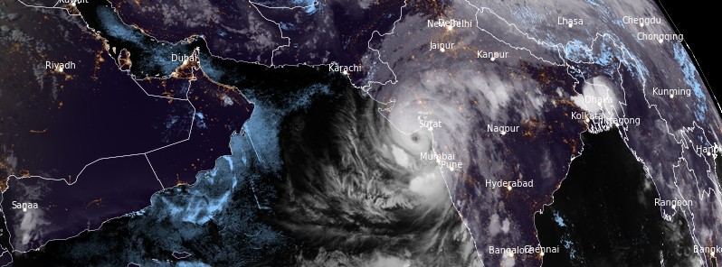
Massive cyclonic storm over India called "Tauktae".
 watchers.news
Winds have reached a blistering 215 km/hr (130 mph) at one point and is accompanied by huge amounts of rainfall. The cyclone eventually made landfall on the western coast of India (near Jafarabad and Mumbai).
Extremely Severe Cyclonic Storm “Tauktae” makes landfall over the coast of Saurashtra, Gujarat, India
Extremely Severe Cyclonic Storm "Tauktae" has started to make landfall over the coast of Saurashtra, between Diu and Una, Gujarat, India at around 15:00 UTC on May 17, 2021. This is the first named…
watchers.news
Winds have reached a blistering 215 km/hr (130 mph) at one point and is accompanied by huge amounts of rainfall. The cyclone eventually made landfall on the western coast of India (near Jafarabad and Mumbai).
Transient 3
What you see here is about 6 months of effort boiled down to 3 minutes. 2020 was a tough year for creatives like myself. Commissioned work in the arts took a severe hit. But I made the best of it. All of the time off gave me ample time to chase. So, I chased!!! I chased so much that I needed to buy a new engine for my truck. I chased so much that it took me 2 months to edit all of the raw footage.
We captured over 400 shots in the Summer of 2020. 101 shots made this video. I hope you enjoy. Stats: Miles traveled - 38K, Terabytes of footage - 12, Days on the road - 64, Blown engines - 1, Days editing - 60 (ish), Speeding tickets - 1 (Bought a radar detector this year), States visited - 12, Viruses contracted - 0 (I think)
Post-Tropical Cyclone #Ana Advisory 8: Ana Becomes a Post-Tropical Cyclone. This is the Last Nhc Advisory On Ana. http://go.usa.gov/W3H 7:40 PM · May 23, 2021·National Hurricane Center
Varied weather with showers and storms today. The Cold Front is approaching central Slovenia. In Novo mesto 24 ° C, in Maribor only 12 ° C. Even near Storm Hills ...
Varied weather with showers and storms today. The Cold Front is approaching central Slovenia. In Novo mesto 24 ° C, in Maribor only 12 ° C. Even near Storm Hills ...
#Orages quite strong currently between #pau and #tarbes but also in #ariege : 30mm of precipitation recorded at #saintgirons (22mm in 12 minutes). Meteociel
Lightning strikes in Del Rio, Texas, yesterday 1-6-2021 #Texas
First images of the negative effects of the storms this afternoon. Sowing of razed onions in the vicinity of Santa Marta (La Roda). Up to 27.5l / m² dropped in La Lobera (Minaya). Photos by unknown author.#Albacete#meteoAB
Meteo Hellín @MeteoHellin
Más efectos negativos de las tormentas de esta tarde. Daños en los frutales del tercio sureste del municipio de Hellín (#Albacete), limítrofe con Jumilla (#Murcia), inmediaciones del Rincón de la Dehesilla. #meteoAB © Pedro Giménez

2:46 PM · Jun 1, 2021
More negative effects of the storms this afternoon. Damage to fruit trees in the southeastern third of the municipality of Hellín (#Albacete ), bordering Jumilla (#Murcia ), near Rincón de la Dehesilla.#meteoAB
The thunderstorm cells although often isolated, have sometimes left copious amounts of rain today in a short time. We can see 42.8 mm at Felletin in the #Creuse , 38.2 mm at Gaillard in #HauteSavoie and 32.6 mm at Clermont Ferrand in the #PuydeDome . Data source: MC
Line-1
Regional disparities are strong. Due to the low rainfall in May, the index is lower than the first decile in the Hautes-Pyrénées, Haute-Garonne, Ariège and Aude. On the other hand, no department is above the eighth decile.
Line-2
The rains of the days to come, sometimes abundant in thunderstorms, will be especially beneficial to the vegetation. To recharge groundwater, which is often deficient and declining, it is too late. The #sécheresse may be a concern of the summer.
USA: 9:39 AM · Jun 1, 2021
Michael CharnicK @charnick_w
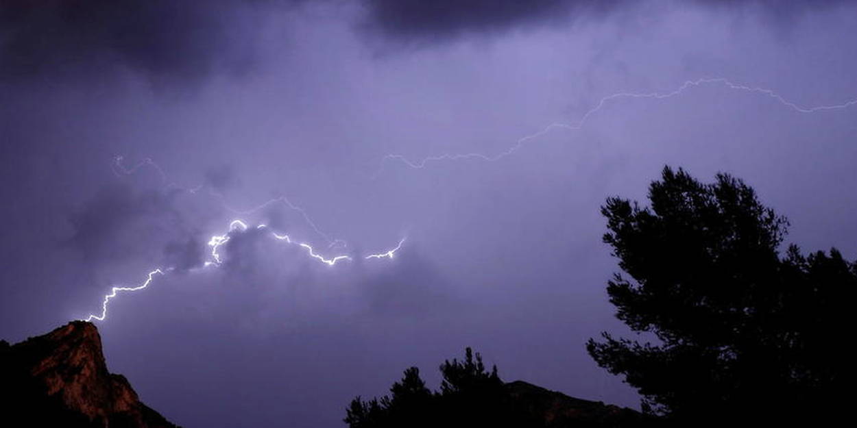
Sprites!!! Camping in Big Bend National Park in one of the most remote locations in the USA. Looking across Mexico toward Del Rio Texas last night, saw numerous sprites with the naked eye for the first time. Unforgettable! #sprites #lightning #TXwx
Lightning strikes in Del Rio, Texas, yesterday 1-6-2021 #Texas
First images of the negative effects of the storms this afternoon. Sowing of razed onions in the vicinity of Santa Marta (La Roda). Up to 27.5l / m² dropped in La Lobera (Minaya). Photos by unknown author.#Albacete#meteoAB
Meteo
Hellín @MeteoHellinMás efectos negativos de las tormentas de esta tarde. Daños en los frutales del tercio sureste del municipio de Hellín (#Albacete), limítrofe con Jumilla (#Murcia), inmediaciones del Rincón de la Dehesilla. #meteoAB © Pedro Giménez
2:46 PM · Jun 1, 2021
More negative effects of the storms this afternoon. Damage to fruit trees in the southeastern third of the municipality of Hellín (#Albacete ), bordering Jumilla (#Murcia ), near Rincón de la Dehesilla.#meteoAB
The thunderstorm cells although often isolated, have sometimes left copious amounts of rain today in a short time. We can see 42.8 mm at Felletin in the #Creuse , 38.2 mm at Gaillard in #HauteSavoie and 32.6 mm at Clermont Ferrand in the #PuydeDome . Data source: MC
Line-1
Regional disparities are strong. Due to the low rainfall in May, the index is lower than the first decile in the Hautes-Pyrénées, Haute-Garonne, Ariège and Aude. On the other hand, no department is above the eighth decile.
Line-2
The rains of the days to come, sometimes abundant in thunderstorms, will be especially beneficial to the vegetation. To recharge groundwater, which is often deficient and declining, it is too late. The #sécheresse may be a concern of the summer.
USA: 9:39 AM · Jun 1, 2021
Michael CharnicK @charnick_w
Sprites!!! Camping in Big Bend National Park in one of the most remote locations in the USA. Looking across Mexico toward Del Rio Texas last night, saw numerous sprites with the naked eye for the first time. Unforgettable! #sprites #lightning #TXwx
Orages : trois départements du nord de la France en vigilance orange
Le Nord, le Pas-de-Calais et l’Aisne ont été placés en vigilance, vendredi 4 juin, à 11 heures. Météo-France met en garde contre de soudaines inondations.
 www.lepoint.fr
The Nord, Pas-de-Calais and Aisne were placed in vigilance, Friday, June 4, at 11 am. Météo-France warns of sudden floods
En this beginning of June, the weather remains decidedly capricious. While summer should arrive in a fortnight, and the month of May brought its share of gray, France was no doubt expecting a somewhat more lasting calm these days. But heaven has decided otherwise. After Seine-et-Marne and Île-de-France affected by violent thunderstorms in the last 48 hours, it is the turn of part of northern France to have to prepare for an intense meteorological phenomenon that s 'ready to disembark.Thus, Friday June 4, in its 11 o'clock bulletin, Météo-France placed three departments on orange vigilance for thunderstorms. These are the Nord, Pas-de-Calais and Aisne. The forecaster site evokes a phenomenon of "high intensity", responsible for "intense electrical activity". And warns against "heavy rains that can lead to sudden flooding." For now, the alert is in effect until Saturday, June 5, 6 a.m.
Thunderstorms… and hail?
Friday, at the end of the morning, Météo-France indicates that the thunderstorms which touched the Paris region earlier in the morning are moving towards Hauts-de-France "losing their activity". The agency plans a "stormy reactivation (...) of the Massif Central at the Belgian and German borders" for the beginning of the afternoon. And specifies: “The most violent thunderstorms are expected in the east of Hauts-de-France. »Accumulations of 30 to 60 millimeters in less than an hour are to be expected. Hail could also surprise residents. Finally, during thunderstorms, gusts can reach 80 to 100 km / hour.A #orage of rare intensity touched #Paris around 7:30 am with #pluies torrential: 16 mm fell in less than a quarter of an hour. Result: nearly 300 km on the roads of #IledeFrance . In time-lapse images, the arrival of the storm seen from the camera on the roof of the tower
@TF1
#Orage at #Paris : the peak of traffic on the roads of #IledeFrance reached shortly after 9 a.m. with 425 km of #bouchons , an "exceptional" level for a Friday ... It is quite simply as much as what had been measured on Wednesday, May 12 in the evening, the day before the Ascension Bridge!
@LCI
8am: the sky is impressive in front of the #orage in Chambly! Take care in the Chambly / Beaumont / Persan sector, which has already suffered #inondations last Wednesday! #meteo#nordparisien
Here's a video of a truly incredible hail storm that happened in Andrews, Texas on 1st of June. Apparently it was really unique, and the storm looked like giant columns.
Also a note for those who fear spiders, that there is a short footage of one before the storm. It just crosses the road.
Also a note for those who fear spiders, that there is a short footage of one before the storm. It just crosses the road.
Last edited:
Adaryn
The Living Force
Friday, June the 4th: in Reims, Northern France, 2 months of rain fell in a few minutes:
XPan
The Living Force
Friday, June the 4th: in Reims, Northern France, 2 months of rain fell in a few minutes:
Catania in East Sicily
Is like that every year, once or twice. As the city is leaning downwards towards the coast - due the prolonging of the Etna Volcano, all water runs down through the city, down the main street of Via Etnea. I have never seen it myself live - but noticed a couple times that when I arrived only 2 days later - you saw nothing of it. Quite puzzling.
But for the many stores along Via Etnea, it is a huge problem with water coming in. And busses often still try to drive in the same rushing water like seen in the videos above. Crazy. There are plenty of videos on Youtube with torrential rainfalls affecting Via Etnea in Catania.
VIDEO CORRECTION: A supercell thunderstorm on Saturday led to France's 'darkest day' this year. With heavy rain and flooding, the storm recorded around 44,000 lightning strikes. We will delete previous videos containing a spelling error
A #orage torrential parked on #Beauvais between 10 p.m. and 11 p.m. this Monday: more than 100 mm of #pluie (nearly 2 months of rain) in 1 hour and significant #inondations . Strong activity #foudre and so-called "penetrating" cloudy tops (-55 ° C) testify to the power of this storm.
USA - Tx
A #orage torrential parked on #Beauvais between 10 p.m. and 11 p.m. this Monday: more than 100 mm of #pluie (nearly 2 months of rain) in 1 hour and significant #inondations . Strong activity #foudre and so-called "penetrating" cloudy tops (-55 ° C) testify to the power of this storm.
USA - Tx
Last edited:
Powerful storms rip through Belgium, including a tornado that obliterates almost 100 homes in country's south
Other tornadic activity over the past few days include:
Deadly tornado touches down near Montreal, Canada
'Large and extremely dangerous' tornado hits Chicago suburbs
Deadly tornado strikes Auckland, New Zealand
Trending content
-

-
Thread 'Coronavirus Pandemic: Apocalypse Now! Or exaggerated scare story?'
- wanderingthomas
Replies: 30K -
