The Ice Age Cometh! Forget Global Warming!

Atlantic hurricane season breaks records: storm 30 has formed - Iota


YGMB4XN7QFHL5AW4BXF5BMEPPE.png


2efec6a76689fffbf7ec1f7e24bd48f3.png


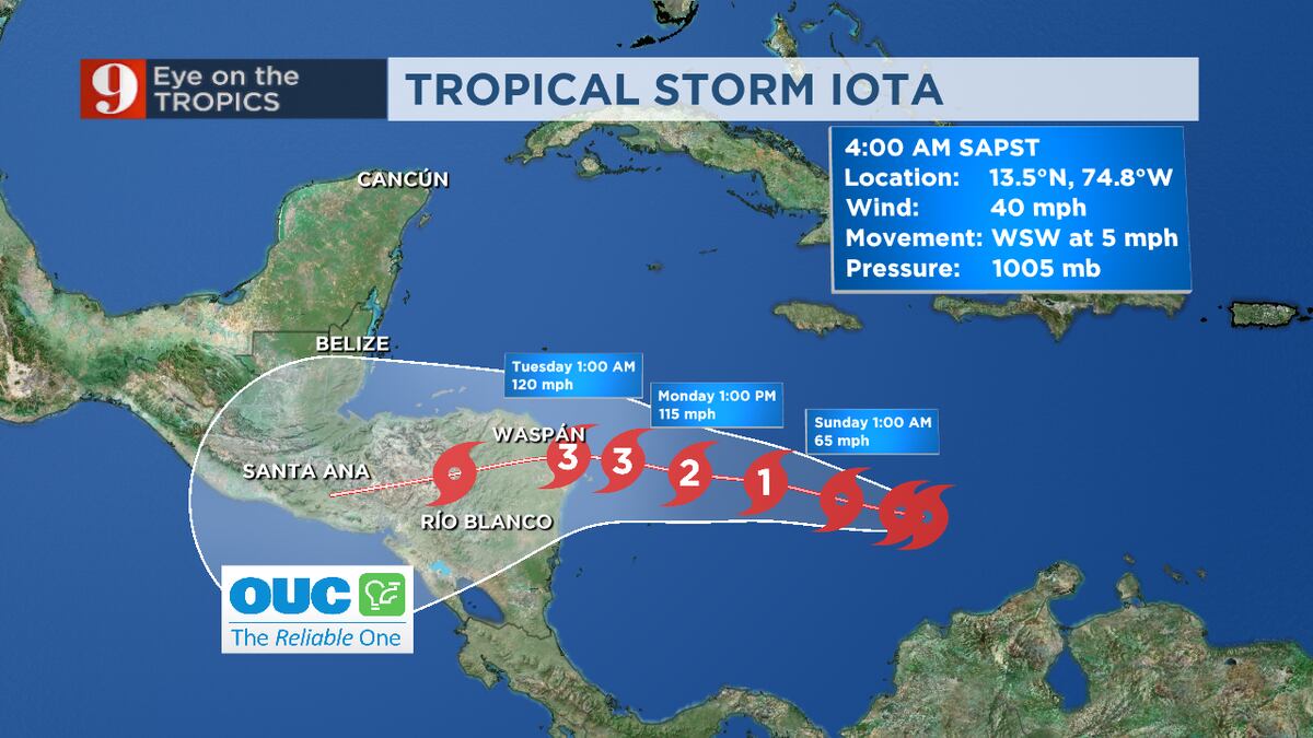
According to the National Hurricane Center in the United States, on November 13, in the center of the Caribbean Sea, another tropical storm, named "Iota", developed from a low pressure area.

Currently, the weather system is located north of Colombia and is moving south-west at a speed of about 5 km / h, wind speed in gusts reaches about 18 m / s. Based on forecasts, on November 15, Iota will intensify to a hurricane, coming ashore on November 16 near the Nicaraguan-Honduras border.

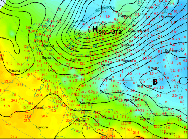
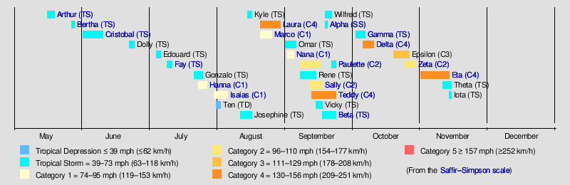
This season of hurricanes in the Atlantic has already broken all records - 30 named storms and an ended list of names for hurricanes, which forced meteorologists to start using letters of the Greek alphabet. The record was previously set in 2005 - 28 storms.

However, the season is not over yet. The 31st storm will be named Kappa, and the next will be named Lambda. The Atlantic hurricane season officially ends on November 30, but Atlantic hurricane history has seen tropical weather systems occur after that date.

PS Let's not forget that the recently ended hurricane Eta killed more than 160 people, with Guatemala and Honduras hit harder than others. And another hurricane Iota will strike in the same place.
 
The weather in Russia turned upside down: in Arkhangelsk +7, in the Rostov region −21

An unusual temperature distribution was noted on November 19–20 in the European part of Russia. It was much warmer in the Russian North than in the south of the country. In particular, in Arkhangelsk the maximum thermometer showed +7, while in Rostov-on-Don it was only -3.

Tx-640x474.png


The difference of 10 degrees was a consequence of the transfer of tropical heat to the north of Russia and the transfer of the Siberian cold to the south of the country. We reported on the exit of the former tropical Atlantic hurricane "ex-Eta" to the north of Europe. The posttropical heat wave involved in it brought heat records to the Northwestern District. On November 19, in St. Petersburg (+10.9), Arkhangelsk (+7.0), Petrozavodsk (+9.8) and Pskov (+11.0), the absolute temperature maximums were updated.

Tn-640x474.png


In the south of Russia, on the contrary, a cold continental anticyclone with the center in the Trans-Volga region ruled. The eastern atmospheric process brought 20-degree frosts to the region!

-----------------------------------------------------------------------------

In Vladivostok, about 30 mm of precipitation fell in 1.5 days. There, something similar happened to what happened not so long ago in the United States, when a cold front from Canada reached the southern United States and caused glaciation on plants and trees.

There are many photos from Vladivostok, I could not insert them into the message - Владивосток стал хрустальным: фотообзор
 

POSSIBLE CME IMPACT: A CME launched by yesterday's M4.4-class solar flare might sideswipe Earth's magnetic field on Dec. 1-2, according to NOAA analysts. The glancing blow, if it occurs, is expected to cause no more than minor G1-class geomagnetic storms with auroras over high-northern latitudes. Scroll down for the full story. Instant geomagnetic storm alerts: SMS Text.

MAJOR SOLAR FLARE AND CME (UPDATED): Yesterday (Nov. 29th at 1311UT), Earth-orbiting satellites detected the biggest solar flare in more than 3 years. NASA's Solar Dynamics Observatory recorded this extreme-ultraviolet movie of the M4.4 category blast:

Cosmic Rays Solar minimum is underway.
The sun's magnetic field is weak, allowing extra cosmic rays into the solar system. Neutron counts from the University of Oulu's Sodankyla Geophysical Observatory show that cosmic rays reaching Earth in 2020 are near a Space Age peak.

Oulu Neutron Counts
Percentages of the Space Age average:
today: +9.7% High
48-hr change: +0.8%
uparrow_orange.png

Max: +11.7% Very High (12/2009)
Min: -32.1% Very Low (06/1991)
explanation | more data
Updated 30 Nov 2020 @ 1700 UT


Tuesday, Dec. 1, 2020


We are coming in December which also means entering the meteorological winter! This year, December is set to get off to a cold and hectic start. A bit like the image of three years ago in 2017, although every situation is never the same ...

anim_hcg9.gif


The weather will change from Tuesday afternoon with the arrival of a disturbance from the north, driven by a cold drop in altitude (-30 ° c to ~ 5500m and -4 ° c to ~ 1500m). This disturbance will be of low intensity with a rain-snow limit which will drop to 1000m on Tuesday evening.

Wednesday morning, the cooling will be important under the influence of this cold drop and it will snow until the Pyrenean foothills, in the form of showers from 500 / 600m. No large quantities to expect, with ground resistance from 700m and cumulative amounts which should be around 5 to 10cm above 1000m, or even 15cm, especially on the Ariège side. These flurries will gradually subside on Wednesday afternoon. Note that the ends of the chain will rather stay apart. The tramontane will blow between 60 and 80km / h in its domain.

Thursday will be a day of transition between two disturbances. A little warmth will occur with a 0 ° C isotherm rising to 1900m in the afternoon. The sky will be divided everywhere between clouds and clearings.

From Friday, the famous descent of maritime polar air that we spoke about in the previous article, will land in the country. This should bring some winter hustle and bustle into the entire weekend. However, the deadline is approaching and many uncertainties are still relevant, especially regarding the accumulation of precipitation and snow in the mountains!

This polar descent indeed gives a hard time to our models! The placement of low pressure excavation in the British Isles is still poorly understood and secondary excavation in the Mediterranean over the weekend remains possible.

All this will therefore have repercussions on the sensitive weather in the Pyrenees with more or less heterogeneous rainfall.

We retain two scenarios for the moment:

The first sees a northwesterly flow penetrating enough inland which would cause heavy snowfall in the mountains up to fairly low altitude (~ 800m). The western Pyrenees could experience significant amounts of snowfall in the mountains: 50cm to 1 meter of snow. But these accumulations would be clearly decreasing by going east with no more than 15cm at Font-Romeu, for example.

The second scenario envisages much more modest and scattered snowfall until the weekend with around 10 to 20cm generally on the massif. The dynamism would indeed be pushed off the ocean in this context.

Within 48 hours, we will normally have more information to anticipate this first real winter assault of the season.

See you soon…The Pyrénées Weather Team


1606802257237.png
 
Last edited:
Russian Emergencies Ministry warned of abnormal cooling in Chelyabinsk region.
The Southern Urals for five days will become an area of abnormal cooling. According to the press center of the Ministry of Emergency Situations of Russia in the Chelyabinsk region, from 1 to 5 December in some areas of the region is expected abnormally cold weather with an average daily air temperature of seven degrees below normal.

543kuvape.jpg


"There is an increase in the probability of emergencies caused by accidents at facilities and power lines, emergency shutdown of life support systems in case of power supply failure, the growth of fires in the residential sector, an increase in cases of general overcooling and frostbite, an increase in the number of accidents, - predict the Ministry of Emergency Situations. - Children and elderly people are in the risk group: they are most exposed to hypothermia. In older people, as a result of certain diseases, thermoregulation can be disrupted, and in children this function of the body is still imperfect.

By the end of the week in the Chelyabinsk region it is predicted up to minus 27 degrees in some areas. In Chelyabinsk, the coldest will be the environment when the thermometer column falls below 25 degrees Celsius.
Source: МЧС предупредило об аномальном похолодании в Челябинской области
 
From the BBC...I'm wondering why this would happen? It's not as if they didn't know when the satellites would need replacing! The timing seems suspicious. Is this really about a 'gap' or are they finding early excuses for communication interruption caused by solar/cosmic activity?

 
From the BBC...I'm wondering why this would happen? It's not as if they didn't know when the satellites would need replacing! The timing seems suspicious. Is this really about a 'gap' or are they finding early excuses for communication interruption caused by solar/cosmic activity?

Upon further reading, the 2-5 year gap they state seems like a worst case scenario if no action was taken to remedy it. There are 2 satellites right now patrolling the ice caps: CryoSat-2 and IceSat-2. According to the article, CryoSat-2 will not last much longer given that it's way past its operation time and also has battery/fuel issues. IceSat-2 however, is still within its design life of 3 years (launched in 2018). However, seeing as how CryoSat-2 has outlived its design life for about 6 years now, it seems safe to say that IceSat-2 will be quite alright.

Back in late September, a deal was made between Airbus Defense and the European Space Agency to develop a polar-monitoring satellite nicknamed CRISTAL. Perhaps this is the replacement to the old CryoSat-2 and is their response to this potential gap.
 
After sunset on December 21st, 2020, the start of the winter solstice, Jupiter and Saturn will look like a double planet. This has not been seen since March 4, 1226. Robert Felix mentions in his book: "Not by Fire but by Ice" that these alignments cause what is known as a solar retrograde cycle. From the book:

On earth, the solar retrograde cycle triggers fluctuations in geomagnetic-field intensity while causing abrupt – and extreme – changes in climate. The changes are so severe that at every other beat of the cycle – approximately every 360 years – the earth plunges into a Little Ice Age.
This cycle has plagued our planet for hundreds of millions of years.
“The 360-year Little Ice Age cycle shows up in the Morrison Formation clear back in the Jurassic,” says research geologist Jack Sauers. “It correlates with the fall of the Roman Empire. It correlates with the fall of the Sumerian Empire. It correlates with the fall of the Ottoman Empire (when Ghengis Kahn swept out of the north). It correlates with the fall of the Greek Empire. And it is now coinciding with the collapse of several modern-day empires.”

Unfortunately, the last beat of the Little Ice Age cycle occurred almost exactly 360 years ago. “If this pattern holds,” said Fairbridge and Sanders, “then a comparable Little Ice Age can be expected to begin . . . early in the twenty-first century.”

But wait. It gets worse. Multiply the Little Ice Age cycle by four, and you get a 1440-year cycle of even harsher climate conditions. This cycle, discovered in the Greenland Ice Sheet, was reported by Paul Mayewski et al. in 1997. (Journal of Geophysical Research, 30 Nov 1997)
The 1440-year cycle brings with it “dramatic and rapid” changes in climate (dry in some areas, wet in others) and worldwide glacier expansion. The cycle appears to be related to internal oscillations in the ocean-climate system, says Mayewski (which I attribute to underwater volcanism, triggered by changes in geomagnetic intensity, triggered by the changes in the sun).
Whatever causes it, a similar 1440-year cycle has been found in North Atlantic deep sea cores (Bond et al., Science, 14 Nov 1997). Our climate plunged into frigid conditions about 4200 years ago, said Bond. Similar declines occurred about 2800 years ago and 1400 years ago, which means – you guessed it – that the next beat of the 1400-year cycle is due.

As if that weren’t enough, multiply the 1440-year cycle by eight, and you come up with 11,520, which is suspiciously close to the 11,500-year ice-age cycle.

So here we sit. The next beat of the 179-year solar retrograde cycle is due. The next beat of the 360-year Little Ice Age cycle is due. The next beat of the 1440-year ice-age cycle is due. The next beat of the 11,500-year ice-age cycle is due. The next beat of the 100,000-year ice-age cycle is due . . . and we’re worried about global warming?
 
Some amazing footage of the seriously deep snow in Norilsk City, Russia and in the Alps


---------------------------------------------------------------------
That it snows in the mountains in December is not at all exceptional. But in recent hours, up to two meters of snow fell in the Alps and that causes problems here and there. There is also an avalanche danger in many places.

Traffic in particular will experience a lot of disruption on Sunday. There are currently no trains running on the Brenner Pass between Austria and Italy. Car traffic is also partly blocked.

There are power supply problems throughout South Tyrol, according to the civil defense. Some 1,400 firefighters have been active since Sunday morning. The highest avalanche warning applies in East Tyrol in Austria. That is why avalanches are generated spontaneously, some of them very large, the local authorities warn.

100 people evacuated

And there are also problems with rail and road traffic in Switzerland. In some places there are floods due to melted snow. In the Austrian village of Prägraten, another incident occurred on Saturday: a mass of snow fell on four houses and a car. No one was injured, but some 100 people had to be evacuated. Residents in the region are urged to stay indoors.

The situation is expected to improve only gradually, as another meter of snow is expected on Sunday.
 
Since Dec 1, the cumulative #pluies are consistent between the southern #Landes and the #PaysBasque where the monthly norms are already exceeded.#Biarritz thus experienced 4 consecutive days at more than 45 mm, unheard of since the start of the surveys in 1956!
@LCI


La Mongie 1800 this morning @ flo_maurin16 #bigorre#pyreneesthe meter is exceeded cumulatively on the 64 and 65 around 2000m for 72 hours

Vallées de Gavarnie
Eon9ZjXW8AInQSJ

The teams of the Nordic Area of Val d'Azun are preparing 10:22 AM · Dec 7, 2020
 
And now also 'unseasonable' summer snow in New Zealand has blanketed regions below 200m! Apparently temperatures plummeted overnight and this climatic event is consistent with a Grand Solar Minimum and not Anthropogenic Global Warming.

The Arctic warms during times of otherwise “global” cooling. This phenomenon has long been accepted by NASA, among others (click here for more). But “warm” to the Arctic is still well-below freezing, there is no significant loss of sea ice, and as temperatures in the far-northern latitudes do climb its polar cold is displaced south where it freezes the lower-latitudes.

This is how ice ages begin.

Furthermore, this weekend’s cold is forecast to only intensify over the coming weeks, particularly across east Asia where temperature departures some 20C below the winter norm will engulf a staggeringly-large portion of the continent:
1607854429148.png
These predicted temperatures are the definition of extreme, and will undoubtedly prove record-breaking, disruptive, and even deadly.

December’s average low-temperature in Yakutsk, Russia, for example, is -40.4C (-40.7F), dipping 20C below this will rank as one of the coldest readings ever recorded in the Northern Hemisphere (with the coldest-ever being the -69.6C (-93.3F) in Dec.,1991 set at The Klinck station, Greenland–during the height of the global warming scare no less).
 
Back
Top Bottom