First direct proof of mega-flood in Mediterranean Sea region
Geologists from Utrecht, London and Granada have found the first direct proof of the largest known mega-flood that ever occurred on earth.
Interesting study here that shows first evidence of the previously theorized megaflood in the med. known as the 'Zanclean flood'.
Basically, according to official chronology, the straits of Gibraltar "closed" about 6 million years ago and much of the Med. dried up, dropping sea levels by more than 1km.
A little while later (
 ) but still in the circa 6 million years ago time frame, the straits "opened" again, and Atlantic waters flooded back in, increasing sea levels (by tens meters per day at times), evidence for which was discovered recently. Here are the basic deets:
The waters of the Mediterranean Sea and the Atlantic Ocean flow back and forth and mix via the narrow Straits of Gibraltar. During the Messinian era, around six million years ago, this flow was disrupted by a tectonic closure of the straits. As a result, much of the Mediterranean Sea evaporated faster than rivers could supply more water.
A kilometre-thick layer of evaporite (gypsum and salt) gradually formed over the entire Mediterranean Sea basin. At the beginning of the Zanclean, around 5.33 million years ago, the Mediterranean filled once again to today’s current level when the connection with the Atlantic Ocean was restored. Models indicate that this was due to an enormous flood entering the Mediterranean basin via Gibraltar. However, until recently there was no geologic proof of such a mega-flood in the geological record of the Mediterranean Sea region.
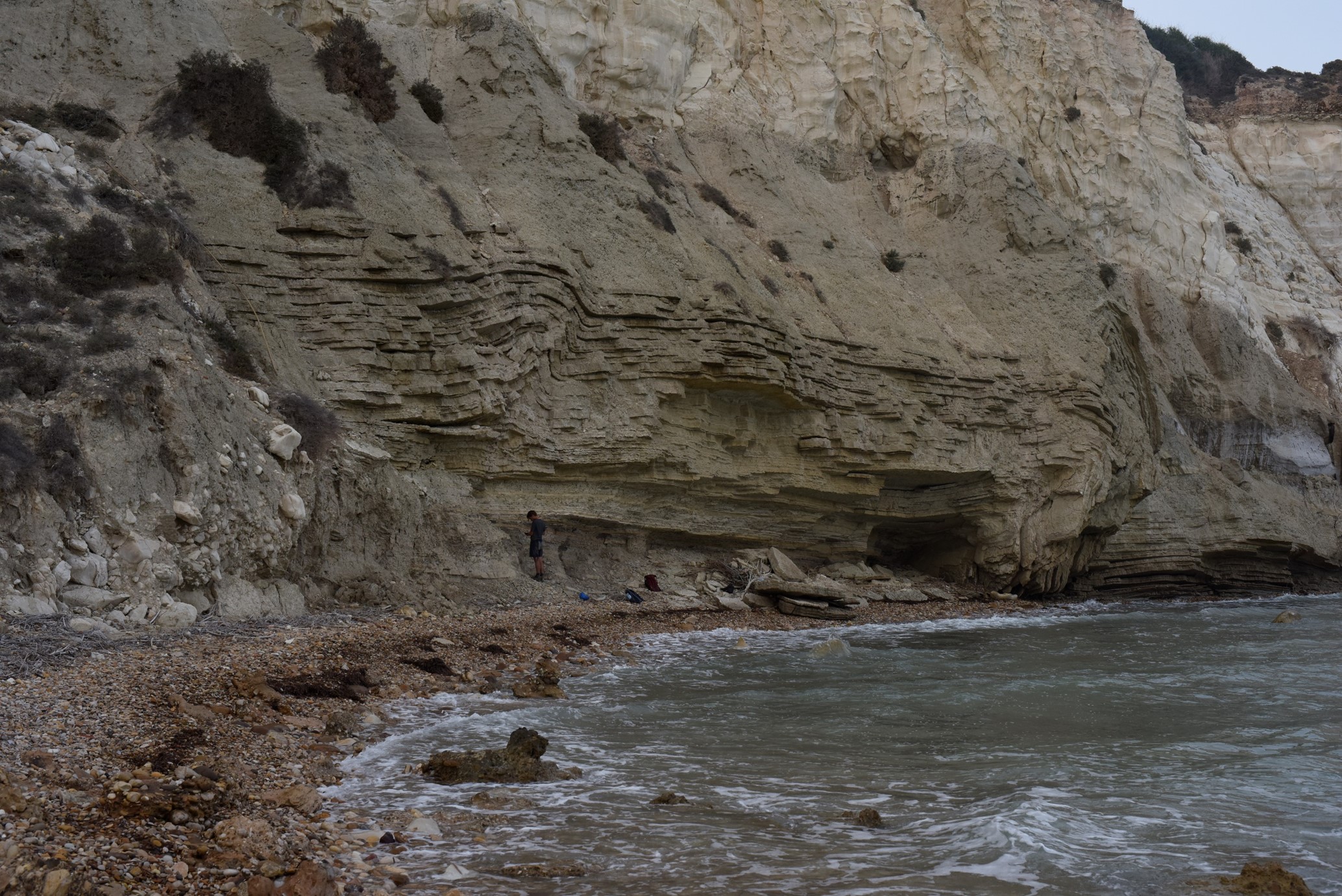
The researchers carefully studied the sand and saw that the composition and size of the grains changed every few centimetres. “We soon recognised the structures of fossilised current ripples in the sand”, recalls Gijs van Dijk, one of Krijgsman’s former Master’s students at Utrecht University and main author of the new study. “Those structures form when fast-flowing water carries sand. We’re all familiar with the pattern, for example where the sand has been exposed to strong wind or fast water currents for a longer period.” The team took photos of the structures, and from their geometry the researchers derived the ancient flow directions and conditions that shaped the sand 5.3 million years ago. They discovered that the sand had not been carried by local rivers or deltas, but that it was formed by a strong underwater current that flowed from west to east in water that was deeper than had previously been assumed.
So anyway, this made me think of the "pillars of hercules" a phrase applied in Antiquity (supposedly) to the rock of Gibraltar and some unknown but theorized mountain in either Morocco or Ceuta. Plato placed "Atlantis" beyond these pillars. The problem is that there is nothing in the modern topography of this area of the Med. that could conceivably have led peoples in the past to refer to them as Pillars, much less of Hercules (in his 10th task, Hercules smashed through a mountain that allegedly spanned the area).
If, however, the Med was mostly dried up, the exposed sea bed was a valley between much of the SE coast of Spain and NE coast of Morocco, effectively the slopes of two opposing mountain ranges. Moving westwards, these two 'pinched' together forming the two 'nipple-like' promontories of Southern Spain and Northern Morocco that we know today. But back then, they were much more dramatic, and probably warranted the name, 'the pillars of hercules'.
Of course, all of that presumes that the official date is waaaay off. From 6 million YA to circa 12k YBP. Or maybe 80k YBP
Some images below:

Artist's depiction of the reflooding of the Med.

Last edited:


