Volcanoes Erupting All Over

Mauna Loa, Hawai'i, US
17 Oct 2022

It seems that the restlessness at the mighty Mauna Loa continues, while authorities tell citizens to prepare for an eruption... Vulkane.net wrote an article on the subject:


Residents of Mauna Loa volcano told to prepare for volcanic eruption 🤔
by Marc Szeglat


State: USA | Location: 19.47, -155.59 | Eruption: Seismic

Bild_2022-10-17_133207922.jpg

Yesterday, more weak earthquakes occurred under the world's largest volcano - Mauna Loa in Hawaii: the HVO recorded 35 tremors. Since last month, earthquake activity and inflation have increased significantly. The steepening of the volcano's structure is caused by magma accumulating in the upper level of the magma bodies beneath the volcano. In fact, the HVO advises residents of the volcano, as well as all residents of Big Island Hawaii, to prepare for a possible imminent volcanic eruption. There are links to the Hawaii Civil Defence Office that flesh out what these preparations should look like. It is recommended that each household prepare an action list to help ensure that each member knows what to do in the event of an emergency.

This includes preparing for evacuations and developing an escape plan. It is recommended to stock up on emergency supplies and pack an escape bag. This escape bag should contain important papers, documents and medicines. You should always have such an escape bag at hand, even in case of non-volcanic natural disasters. It is also important to remember that the archipelago of Hawaii is completely isolated in the Pacific and could be cut off from the outside world in the event of a major disaster. I am thinking, for example, of volcanic ash paralysing air traffic.

Recommendations for emergency preparedness were recently issued by the German Federal Office for Civil Protection. Here, however, less with a view to a supposedly imminent volcanic catastrophe, but with a view to a possible imminent blackout of the power supply in winter. Such a blackout has never been more likely in Germany and Europe than in the coming winter. The reason for this is to be found in the energy crisis. Citizens should stock up on emergency supplies for at least 14 days. But back to Hawaii.

The head of the Hawaii Civil Defence Authority - Talmadge Magno - told in a television interview with the local station KHON2 that he himself lives on the slope of the volcano, and that a good half of the volcano's residents must expect to be directly affected by a volcanic eruption. What this can mean was experienced by the residents of the settlement of Leilani in 2018, when an eruption of Kilauea volcano destroyed more than 700 houses.


END OF ARTICLE
 
Cotopaxi, Equador
22 Oct 2022 •

A rather rare message comes from the mighty (5897 m / 19,347 ft) Cotopaxi volcano in Equador, which emits steam since a couple days. Apparently even a small ash eruption seem to have occurred.


German Vulkane.net reported following today:


Cotopaxi with VONA warning
by Marc Szeglat

Ffm32dfWQAEpHLH.jpg

State: Ecuador | Coordinates: -0.081, -77.67 | Eruption: Phreatic

Ecuador's Cotopaxi volcano has been emitting a steam cloud for several days, causing concern among volcanologists and local residents. It rose several hundred metres above the crater and contained a high concentration of sulphur dioxide. The IGPEN determined a sulphur dioxide emission of a good 2200 tonnes per day. Then yesterday, a small volcanic eruption seems to have occurred, as the Washington VAAC reported volcanic ash at an altitude of 8200 metres. The eruption cloud drifted towards the northeast. The activity continues today.

IGEPN volcanologists suspect that the prolonged rains of the last few days led to changes in the volcano's hydrothermal system, creating water vapour that triggered the eruptions. In this case, they are phreatic eruptions. However, these could also be signs that the volcano is heating up. The IGEPN bulletin states that 24 long-period earthquakes and one volcanotectonic tremor were recorded. There was no ground deformation. However, the increased sulphur dioxide emission and the tremors indicate that there is melt in the conveyor system, so phreatomagmatic eruptions could also occur, where there is direct contact between lava and water. Phreatomagmatic eruptions can become quite powerful and have great destructive potential.

Cotopaxi has an altitude of 5911 m and is one of the most powerful volcanoes in Ecuador. The catastrophic eruption of 1877 is etched in the collective memory of the local inhabitants. At that time, there was a major eruption of the volcano, which has a glacier at its summit. Meltwater triggered a lahar that flowed over 100 km and wiped out the village of Latacunga.

The most recent eruption on Cotopaxi occurred in 2015 and was also of phreatic origin. There were fears of a larger eruption, but this did not happen.


END OF ARTICLE

FaFKyDLXwAATNqf.jpg
Tyler Copenhaver-Heath took / published this beautiful photo at Cotopaxi, on 14 Aug 2022
 
A new study reveals that at the previously 'dormant' Mounth Edgecumbe volcano in Alaska, there has been 'significant surface deformation' and data shows that magma may be rising. They noted an uptick in activity beginning in 2018, and it has continued since.

It's also not the only volcano in Alaska that has seen a surge in activity.


Magma rapidly rising beneath 'dormant' volcano Mount Edgecumbe in Alaska, 'rare reactivation' revealed in new study

Magma rapidly rising beneath 'dormant' volcano Mount Edgecumbe in Alaska, 'rare reactivation' revealed in new study -- Sott.net


Rod Boyce, University of Alaska Fairbanks
Phys.org
Thu, 20 Oct 2022 12:00 UTC


Edgecumbe mount
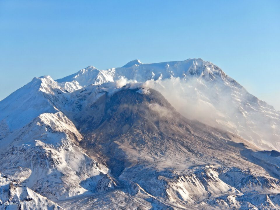
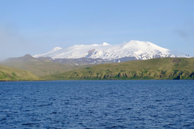
© Max Kaufman /Alaska Volcano Observatory
Mt. Edgecumbe rises in the foreground with Crater Ridge behind and to the north on May 19, 2022.
Magma beneath long-dormant Mount Edgecumbe volcano in Southeast Alaska has been moving upward through Earth's crust, according to research the Alaska Volcano Observatory rapidly produced using a new method.

The new approach at the observatory could lead to earlier detection of volcanic unrest in Alaska.

At Mount Edgecumbe, computer modeling based on satellite imagery shows magma is rising to about 6 miles from a depth of about 12 miles and has caused earthquakes and significant surface deformation.

"That's the fastest rate of volcanic deformation that we currently have in Alaska," said the research paper's lead author, Ronni Grapenthin, a University of Alaska Fairbanks associate professor of geodesy.

"And while it is not uncommon for volcanoes to deform, the activity at Edgecumbe is unusual because reactivation of dormant volcanic systems is rarely observed," he said.

An eruption is not imminent, Grapenthin said.

The findings by researchers at the UAF Geophysical Institute and the U.S. Geological Survey were published Oct. 10 in the journal Geophysical Research Letters.

The Alaska Volcano Observatory collaborated with the Alaska Satellite Facility, another Geophysical Institute unit, to process data in the cloud — a first for the volcano team. Cloud computing uses remote servers to store data and provide computing services so a researcher does not have to download and sort data to process it, something that can take weeks or months.

The research team began its work as soon as a swarm of earthquakes was noticed at Mount Edgecumbe on April 11, 2022. Researchers analyzed the previous 7.5 years of ground deformation detected in satellite radar data.

Four days later, on April 15, the team had a preliminary result: An intrusion of new magma was causing the earthquakes. A small number of earthquakes began under Edgecumbe in 2020, but the cause was ambiguous until the deformation results were produced.

Additional data processing confirmed the preliminary finding. The Alaska Volcano Observatory informed the public on April 22, less than two weeks after the latest batch of Edgecumbe earthquakes was reported.

"We've done these kinds of analyses before, but new streamlined cloud-based workflows cut weeks or months of analysis down to just days," said David Fee, the Alaska Volcano Observatory's coordinating scientist at the Geophysical Institute.

Mount Edgecumbe, at 3,200 feet, is on Kruzof Island on the west side of Sitka Sound. It is part of the Mount Edgecumbe Volcanic Field, which includes the domes and crater of adjacent Crater Ridge.

Most striking for the researchers was an area of ground uplift on southern Kruzof Island 10.5 miles in diameter and centered 1.5 miles east of the volcano. The upward deformation began abruptly in August 2018 and continued at a rate of 3.4 inches annually, for a total of 10.6 inches through early 2022.

Subsequent computer modeling indicated the cause was the intrusion of new magma.

The new deformation-based analysis will allow for earlier detection of volcanic unrest, because ground deformation is one of its earliest indicators. Deformation can occur without accompanying seismic activity, making ground uplift a key symptom to watch.

The volcano observatory is applying the new approach to other volcanoes in Alaska, including Trident Volcano, about 30 miles north of Katmai Bay. The volcano is showing signs of elevated unrest.

Mount Edgecumbe isn't showing signs of an imminent eruption, Grapenthin said.


Comment: They've said that twice now; and perhaps an eruption isn't 'imminent', but the word can be rather subjective.


"This magma intrusion has been going on for three-plus years now," he said. "Prior to an eruption we expect more signs of unrest: more seismicity, more deformation, and — importantly — changes in the patterns of seismicity and deformation."

The researchers say the magma is likely reaching an upper chamber through a near-vertical conduit. But they also believe the magma is precluded from moving further upward by thick magma already in the upper chamber.

The new magma is forcing the entire surface up instead.


Mount Edgecumbe is 15 miles west of Sitka, which has a population of about 8,500 residents.

The volcano last erupted 800 to 900 years ago, as cited in Lingít oral history handed down by Herman Kitka. A group of Tlingits in four canoes had camped on the coast about 15 or 20 miles south of some large smoke plumes, according to the account. A scouting party in a canoe was sent to investigate the smoke and reported "a mountain blinking, spouting fire and smoke."

Others involved in the research include Franz Meyer, chief scientist of the Alaska Satellite Facility; UAF graduate students Yitian Cheng, Mario Angarita and Darren Tan; and Aaron Wech of the U.S. Geological Survey.

The Alaska Volcano Observatory is a joint program of the Geophysical Institute, U.S. Geological Survey and the Alaska Division of Geological and Geophysical Surveys.
More information: Ronni Grapenthin et al, Return from Dormancy: Rapid inflation and seismic unrest driven by transcrustal magma transfer at Mt. Edgecumbe (L'úx Shaa) Volcano, Alaska, Geophysical Research Letters (2022). DOI: 10.1029/2022GL099464 Journal information: Geophysical Research Letters
 
Askja, Iceland
25 Oct 2022

There is a lot of unsettled movements going on north of Herdubreid, and Vulkane.net speculates that it could be a precursor of the Askja volcano, preparing for an eruption ?

[26 Oct 2022; 18:35 - possible problems to load pages at Vulkane.net]


Herdubreid earthquakes could precede Askja eruption
by Marc Szeglat

askja.jpg
The small Viti crater lake in the Askja caldera. © Marc Szeglat


Earthquakes at Herdubreid continue

Today the earthquake swarm north of Herdubreid on Iceland continued. It has weakened somewhat, but there are still many weak quakes. In the last 48 hours, 631 tremors were recorded in IMO's tables. 12 tremors had magnitudes between 2 and 3. Not all recorded earthquakes are shown in the tables, so the actual number of tremors is likely to be higher. It is already a remarkable swarm earthquake, but does not quite reach the violent earthquake swarms we saw in recent years, e.g. at Fagradalsfjall, Bardarbunga, or Eyjafjallajökull days before the eruptions. In the case of massive ground uplift due to magma rising to the surface, the earthquakes usually spread over a larger area than we are currently seeing at Herdubreid. Nevertheless, it is reasonable to ask whether the swarm quake is related to magma intrusion and perhaps even heralds a volcanic eruption.

221025_1755.jpg

Does the swarm quake herald an eruption of Askja?

Icelandic volcanologist Ármann Höskuldsson said in an interview with the Icelandic TV station RUV that the swarm quake is remarkable and possibly indicates that the central volcano Askja is ready for an eruption. Herdubreid is within sight of Askja (the distance is 24 km), which stretches its fingers far: they reach into the area around Dettifoss waterfall, which is a good 90 km north of Askja. The Icelandic scientist went on to say that a considerable amount of magma has accumulated under Askja. I can think of 2 ways in which ground uplift and inflation at Askja trigger the earthquakes at Herdubreid: either a magmatic gangue migrates from the magma body under Askja to Herdubreid, or the magma body changes the stress field in the wider Askja area so that tectonic fault zones are activated. In any case, the process of magma accumulation in the area started as early as 2012, and the probability of an eruption increases with each thrust of fresh magma, although an eruption at Herdubreid itself cannot be ruled out. Whether the next eruption at Askja will be explosive, or effusive, cannot be predicted. The volcano has produced both large lava fields and powerful ash clouds in the past.

Earthquake activity in the weekly review

IMO also released today the summary of earthquake activity during the observation period 17-23 October. A total of about 2520 earthquakes were recorded, which is significantly more than the previous week when about 900 earthquakes were recorded. The strongest earthquake was the quake at Herdubreid with Mb 4.1, where there was also the most intense swarm quake. There were also many quakes at Grimsey and Reykjanes. 20 earthquakes were recorded at Grímsvötn and 5 at Hekla volcano.


END OF ARTICLE
 

Hawaii On Red Alert As Earthquake Swarms Detected Under World's Largest Active Volcano​


The Island of Hawaii is on high alert as earthquake swarms continue around the world's largest active volcano, Mauna Loa. Scientists are worried about an eruption but not sure if one is imminent as magma churns underneath, generating dozens of quakes daily, according to AP News.

US Geological Survey's Hawaiian Volcano Observatory said Mauna Loa has been in a state of "heightened unrest" since mid-month due to daily earthquake swarms jumped from 10-20 per day to 40-50 per day.

"Scientists believe more earthquakes are occurring because more magma is flowing into Mauna Loa's summit reservoir system from the hot spot under the earth's surface that feeds molten rock to Hawaii's volcanoes," AP said.

Hawaii's civil defense agency held a meeting earlier this week to educate residents on preparing for a possible eruption.

"Not to panic everybody, but they have to be aware of that you live on the slopes of Mauna Loa. There's a potential for some kind of lava disaster," said Talmadge Magno, Hawaii County Civil Defense administrator.

Mauna Loa is about half of the Hawaii Island landmass. So any eruption would immediately impact residents. There are about 200,000 people on the island. It last erupted in 1984, and lava flows took out homes in under two hours.

USGS data shows hundreds of quakes have rattled the island in the last 30 days.


USGS has placed Mauna Loa under "yellow advisory," ― signifying residents need to be prepared.
 
Maly Semyachik Volcano, Russia
28 Oct 2022

An new volcano held an entry - well sort of: Maly Semyachik located on the peninsula of Kamtchatka, has reactivated an ash cloud (strong winds which reactivate ash into the air). Last eruption occurred back in 1952. German Vulkane.net wrote following:


🇬🇧 english

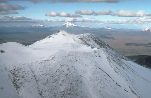
🇫🇷 french (Wikipedia seem to contain more info)

Maly-Semyachik-4141206862.jpg

Maly Semyachik with remobilised ash cloud

The volcano Maly Semyachik is located on the Siberian peninsula of Kamchatka (Russia) and is in the news at vnet for the first time today. The Tokyo VAAC put out a VONA report at 02:13 UCT tonight that volcanic ash had been sighted at an altitude of 4000m. The wind shifted it towards the southeast. The ash was not detected on satellite imagery. At 05:50 UCT, the warning was lifted again. KVERT initially raised the warning level for air traffic to "orange", but meanwhile reduced it again to "green". There had not been a surprise volcanic eruption, but strong winds remobilised old volcanic ash from the volcano flank. We saw something similar at Klyuchevskoy last month.

Another report comes from Karymsky, which lies within sight of Maly Semyachik. Here too, an ash cloud was reported around 01:00 UCT, rising to an altitude of 4800m. This was the 154th VONA report from this volcano in 2022, suggesting that this was also remobilised volcanic ash, although the volcano may have actually erupted.

About the Maly Semyachik volcano

Maly Semyachik is known for its turquoise crater lake. It is located in the southernmost of the volcano's 3 craters and is 550 m in diameter. It is almost circular and up to 180 m deep. The water temperature varies between 27 and 42 degrees Celsius, which indicates changing conditions due to periodic magma rise. We observed something similar at New Zealand's Ruapehu volcano this year. As is typical for turquoise crater lakes, the water has an extremely low pH value caused by sulphuric acid.

Maly Semyachik is a complex stratovolcano consisting of 3 intergrown volcanic cones rising from a 10 km diameter caldera. The 3 volcanoes form a 3 km long volcanic ridge. Each of the cones has its own crater. The last eruption occurred in 1952 and had a VEI 2.


END OF ARTICLE


Additional maps & Images

_-2022-10-29-at-01.45.09.jpgKamchatkaVolcanoesMap.JPG
54e1978b928b72c938db88b32f5187d6.JPG
5b2dd1d6d6727c72434499903b4675c5.JPG
 
Shiveluch, Russia
29 Oct 2022

What's up with the "remobilized" ash clouds ? The Russian volcano Shiveluch reports similar phenomena like Maly Semyachik volcano, and the Karymsky Volcano did; reactivated ash clouds... 🤔 Shiveluch however does have a growing lava dome, with a weak-moderate heat signature detected. German Vulkane.net wrote following:


2869.jpg

Shiveluch with remobilised ash cloud

State: Russia | Coordinates: 56.65; 161.36 | Eruption: Dome

Another ash cloud was detected at Shiveluch, which according to VAAC Tokyo rose to an altitude of 3700 m and was transported towards the southeast. KVERT reported the eruption and declared an "orange" alert level for air traffic. However, the ash cloud is said not to have been actively erupted, but is again remobilised ash stirred up by strong winds. The ash cloud is carried 80 km by the wind. Nevertheless, the dome continues to grow, which is also indicated by moderate thermal radiation with 32 MW power displayed on MIROVA. Explosions, collapse events and pyroclastic flows can occur at any time. The picture shows the lava dome on 17 October 2022.

Kamchatka seems to be particularly windy this autumn, as remobilised ash clouds from Maly Semyachik and Karymsky were already reported yesterday.


END OF ARTICLE
 
Underwater Volcano Ahyi, Pacific Ocean
15 Nov 2022

A more unusual report comes from an underwater volcano called Ahyi embedded among the hundreds of underwater volcanoes along the Mariana islands/trench. I noticed that Sott back in 2014 had an article on the volcano, too. As of now, german Vulkane.net wrote following;


Ahyi underwater volcano may erupt
by Marc Szeglat

According to media reports, acoustic signals have been registered from Ahyi Seamount

• They could be from underwater explosions
• Mariners urged to exercise caution
• Ahyi Seamount generated acoustic signals


GVP-11697.jpg

The underwater volcano Ahyi is located on the northern edge of the Mariana archipelago and is one of several submarine volcanoes there. Scientists suspect the Ahyi seamount was the source of hydroacoustic signals picked up last month by sensors on Wake Island, nearly 2000 km away. Now a team from the USGS wants to investigate whether the volcano is in an eruptive stage or whether the signals were caused by shallow earthquakes near the surface. Initial analyses of satellite images gave no indication of a major eruption, but the situation is nevertheless being eyed warily, as submarine volcanic eruptions harbour some potential dangers.

It is especially important for maritime shipping to be warned about possible degassing: many gas bubbles in the water reduce its density and thus the buoyancy of ships crossing such areas is also reduced. In the worst case, they could sink. Further dangers are posed by large pumice stone carpets: the floating lava stones are a particular danger for smaller boats, as they could get stuck in such pumice stone carpets. Last, but not least, Surtseyan eruptions could break the water surface. But for this to happen, the water above the volcanic craters must not be too deep. As a guideline, eruption columns occur when the water above the craters is not deeper than 120 meters.
The crater of the Ahyi seamount is at a depth of about 75 m. An explosion was last detected in 2014.

The exact number of active submarine volcanoes is not known, but experts assume that it significantly exceeds the number of known active volcanoes worldwide: after all, 70% of the earth is covered by oceans, at the edges of which are the most volcanically active zones on earth. Volcanic islands rise in comparatively few places.

A few large submarine eruptions have occurred in recent years. Examples include the large pumice deposit released from a volcano on the Vava'u Ridge 3 years ago, or the submarine eruption near Mayotte, which caused the entire island to subside, a good 30 km from the suspected eruption centre. And then there would have been the strongest eruption in recent decades, which occurred in December/January at Hunga Tonga-Hunga Ha'api.

That a similarly strong eruption will build up at Ahyi Seamount is very unlikely, if only from a purely statistical point of view. Nevertheless, it cannot be ruled out that a larger eruption will occur there, which will also have an impact on the water surface. The volcanic island arc of the Marianas consists of a good 60 fire mountains and seamounts.


END OF ARTICLE


Location:

th-3410349470.jpg

Older Sott article from 2 May 2014

 
Campi Flegrei, Pozzuoli & Napoli - Italy
15 Nov 2022


Campi Flegrei with earthquake and steam generation
Date: 12 Nov 2022 | Time: 21:37:54 UTC | 40.796 ; 14.117 | Depth: 2 km | Mb 2.7

Bild_2022-11-15_123001124.jpg

Today another small swarm earthquake occurred under the Italian Caldera volcano Campi Flegrei. The INGV registered 11 weak tremors at night with magnitudes smaller than 1. The quakes were thus in the range of microseismicity. The hypocentres were shallow, at depths between 800 and 2000 m. The epicentres were located in the north-eastern area of Solfatara crater. On the crater rim is the Pisciarelli fumarole, from which strong steam emanated. Pictures of it were shared on social media. The fact that more steam was seen is not necessarily related to the earthquakes, but could also be due to meteorological conditions that favour condensation of the steam. In addition, when there is no wind, steam rises higher than is usually the case.

Already on Saturday, there was an earthquake M 2.7, whose epicentre was in the Gulf of Pozzuoli. The depth was given as 2000 m. The quakes occur in the area of the volcano's hydrothermal system and are not directly connected to the magma body. However, fluids could rise from it, inflating the hydrothermal system. In addition, underground magma heats up the fluids, whereupon they also expand and move more, causing tremors.

100 cm ground uplift since 2005

Bild_2022-11-15_124543627.jpg

After a very quiet summer, seismicity and inflation are on the rise again. According to preliminary values, the ground uplift was last 0.7 mm per month. Since 2011, the inflation has added up to approx. 94 cm. If we look at data since 2005, we arrive at 100 cm of ground uplift! This is not yet a record value for the bradyseismos in the Gulf of Pozzuoli, but it is still respectable.

A new weekly report from INGV is expected at noon today, and I will update the data here.


END OF ARTICLE

2012-04-30-21-57-34.jpg
 

Takawangha volcano (Tanaga Island, Aleutians): seismic swarm, alert status raised to Yellow​


The Alaska Volcano Observatory (AVO) recorded a swarm of small earthquakes in the vicinity of the volcano over the past few days.

An increasing trend of the activity peaked with intensified quakes during the past 24 hours. Volcano-tectonic earthquakes were located at shallow depths between 3 and 6 km, of which the largest was recorded with magnitude M 2-3. Earthquakes likely reflected magma intrusions and migration under the surface.

Therefore, the local observatory made decision to rise the Aviation Color Code and Volcanic Alert Level to Yellow.

Takawangha is a 1449-m-high, youthful volcano with an ice-filled caldera on northern Tanaga Island, near the western end of the Andreanof Islands.

Takawangha volcano last eruption: 1550

 
Snip:
1668946145249.png

Natural Disasters

In 1815, Mount Tambora, a supervolcano in Indonesia, erupted. This eruption was the cause of climate change for at least three years afterward due to the gases trapped in the stratosphere. The ash from the volcano spread across the sky, giving the following year the nickname “the year without summer.”

There were such extreme natural disasters that occurred during this time, such as flooding, drought, and wildfires, that people thought it was the end of the world.

This eruption caused a significant chain of events that made this the start of one of the worst periods in history. Without sunlight, rampant crop failure across the Northern Hemisphere led to mass starvation.

Historians believe this eruption caused the death of somewhere between 100,000 and millions of people because climate change allowed a cholera pandemic to infect the people already weakened from starvation.

536: The Worst Year in History

Historian Michael McCormick of Harvard University has been researching what happened back in 536. Some records from historians and politicians spoke of the sun being absent, saying that they no longer had shadows during the middle of the day and of a mysterious fog that descended upon Europe, the Middle East, and Asia. But, without detailed records to tell us exactly what happened, historians like McCormick have been looking for natural indications to tell us further details.

New evidence from glaciers and tree rings indicates that a massive volcanic eruption occurred in Iceland. McCormick proved that volcanic ash had covered the sky by using a unique technique to test the ice on glaciers in Greenland, Iceland, and the Swiss Alps.

There also is evidence of two more supervolcanoes erupting in 540 and 547. As with the Mount Tambora eruption, this caused problems for many people.

The mysterious fog that history tells us about was volcanic ash that blocked the sun from the sky for a year and a half. This time became known as the Late Antique Little Ice Age and is described as a “volcanic winter.”

The eruption caused the climate to change dramatically, causing crops to fail, snow to fall in summer, and temperatures to make it the coldest decade in over 2,000 years.

As if this isn’t horrifying enough, the first bubonic plague immediately hit the world. Millions of people were weakened by the widespread famine and disease ravaged the population, causing the fall of the Eastern Roman Empire. Some historians believe that volcanoes in North America erupted at the same time.

Other historians believe that half world’s population was decimated because of these events. While humanity has felt terror over the years, nothing compares to the Icelandic eruption of 536


Noah's Flood 2807 B.C. - Did An Asteroid Impact Cause A Mega-Tsunami And The Subsequent Mythology?
Premiered 9 hours ago

Volcanoes Live, Worldwide.

 
Last edited:
The Shiveluch volcano is preparing to erupt

20 Nov, 12:58

Highest active volcano in Eurasia begins to erupt in Kamchatka​

Magma ejection with a frequency of up to 10 explosions per hour has been recorded and lava flows are expected

MOSCOW, November 20. /TASS/. The highest active volcano in Eurasia, Klyuchevskoy, has begun to erupt in Kamchatka, the press service of the Far Eastern District’s Institute of Volcanology said on Sunday.
Magma ejection with a frequency of up to 10 explosions per hour has been recorded and lava flows are expected, it said in a release. "The summit eruption of Eurasia's highest volcano, Klyuchevskoy, has begun in Kamchatka. Scientists expect lava and mud streams to flow down the rivers in the volcano's area," the press service said.
The eruption began at the top of the crater. Due to the depth of the volcano - about 200 meters - only isolated eruptions are visible. Scientists warn that the intensity of the eruption will increase. The director of the institute at the Russian Academy of Sciences, Alexey Ozerov, specified that eruptions of Klyuchevskoy Volcano may last from several weeks to a year.
Klyuchevskoy with its height of 4,800 meters is the highest active volcano in Eurasia. Its age is estimated at 7,000 years. The last summit eruption was from early October 2020 to February 8, 2021.

Many earthquakes were also reported:


19-NOV-2022 22:40:40 55.71 162.54 4.4 30 0 NEAR EAST COAST OF KAMCHATKA 11623370
19-NOV-2022 14:23:34 55.65 162.57 5.1 24 7 NEAR EAST COAST OF KAMCHATKA 11623266
27-OCT-2022 02:26:49 55.84 160.98 4.5 149 99 KAMCHATKA PENINSULA, RUSSIA 11613554
23-OCT-2022 00:24:26 54.71 161.52 4.4 56 129 NEAR EAST COAST OF KAMCHATKA
 
Back
Top Bottom