The Ice Age Cometh! Forget Global Warming!

Have you noticed the "sliding values" ?

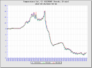
Using the below tweet, when you look at the temperature scale.... notice that orange is a mere 10°C [50°F], and red only 17°C [62.6°F].... Why ? It just "screws with your mind".

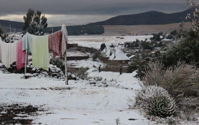
I mean, neither 10°C nor 17°C are temperatures deserving the associations of orange or red colors. The thing is, that the same thing has happened in German TV Weather illustrations: They do the same thing. 30 years ago, you would not assign red colors to temperatures below 30°C, not even below 25°C or 20°C. Today the color scale has been lowered by a lot ! I also notice it here, in this daily updated link for MAX temperatures in Europe (or see illustration below), that temperatures around 23°C are already marked as red.

But that's not any remarkable heat ! Yet, it makes it all look unusual hot....

Talk about psychological voodoo...


Tmax_obs_eu-large_day-1.png
active
 
The following shows the impact that this year's weather has had on growth when compared to last year.

Charles Dowding is an Englishman who grows and sells vegetables in his local area for a living. He's also become pretty popular on Youtube for his successful method of growing that involves using lots of compost and few, if any, additional chemicals in the form of pesticides, herbicides and fertilizers.

As you can see in this post, last year's jet stream was tight and circular leading to stable and mild weather across much of Europe, whilst this year's has been meandering and has resulted in erratic weather patterns with more extreme high and low temperatures.

The difference in growth is rather startling and it's not often i come across an image the makes the point so well. It shows how fragile the growing season is and, were summer to be weak in some way, or should autumn and winter come earlier than expected, the impact this will have on harvest and the food supply could likely be significant. Even more so were this to happen a few years in a row (as has actually been happening).

As was the case throughout Europe this year, a mild end to winter and early start to spring that is punctuated by damaging frosts can be almost as bad for crops, if not worse, than an overall cool spring that causes a slow and weak start to growth.

The video blurb states:
I show the results of low spring temperatures, in contrast to the high ones of 2020. The differences are dramatic. Growth was so slowed by the cold nights of April, that it has been slow to re-establish until just recently. At Homeacres SW England zone 6-8 with normally mild springs, and last frost mid May. April 2021 saw 16 frosts compared to the average 5, and a minimum temperature average in April of -0.2C (average 4C), although days were almost average temperature of 13.4C. May had four frosts up to 7th May, and temperatures are so far just 1.4C below average in May, but April's nights did the damage. April 2020 had four frosts and nights averaged 5.2C, days were average 18C! May 2020 had four frosts with day temperature average of 17.5C up to mid May. In 2021, not one day has been that warm.

Image:1622024644330.png


Video:
 
Last edited:
The following shows the impact that this year's weather has had on growth when compared to last year.

Charles Dowding is an Englishman who grows and sells vegetables in his local area for a living. He's also become pretty popular on Youtube for his successful method of growing that involves using lots of compost and few, if any, additional chemicals in the form of pesticides, herbicides and fertilizers.

As you can see in this post, last year's jet stream was tight and circular leading to stable and mild weather across much of Europe, whilst this year's has been meandering and has resulted in erratic weather patterns with more extreme high and low temperatures.

The difference in growth is rather startling and it's not often i come across an image the makes the point so well. It shows how fragile the growing season is and, were summer to be weak in some way, or should autumn and winter come earlier than expected, the impact this will have on harvest and the food supply could likely be significant. Even more so were this to happen a few years in a row (as has actually been happening).

As was the case throughout Europe this year, a mild end to winter and early start to spring that is punctuated by damaging frosts can be almost as bad for crops, if not worse, than an overall cool spring that causes a slow and weak start to growth.

The video blurb states:


Image:View attachment 45658


Video:
So very true, thank you for posting this! Here in the SW England, we have had such a cool May, heavy cloud and constant rain. Whilst our garden is slightly protected and not suffered too much from the frosts, the rain this month has brought the slugs out in abundance. This time last year, runner beans, French beans and peas/mange touted looked pretty similiar to the growth seen in the May 2020 photos above....this year, any growth has been decimated by those slugs, so I now have to resow EVERYTHING! I can only hope for a warm couple of months in order to catch up, but things do look more promising for June.
 
but things do look more promising for June.
Well, yesterday up in the north of the UK, in Scotland, they were powder snow skiing!

1622046270441.png
From Electroverse:

Scots are suffering a rare late-spring Arctic blast this week as an unusual chill continues to engulf the majority of the European continent.

Inches upon inches of rare and record-breaking late-May snow settled across the higher parts of Scotland, with additional and exceptionally rare flurries descending on low-lying areas, too.

I also like this picture of Ben Nevis, which looks like a scene from Mount Everest:

1622046448154.png

As we approach June, forecasters are anticipating yet more Arctic outbreaks.

Next week, the Met Office is predicting “snow, hail and thunder” to rock Scotland. This is the same Met Office that recently claimed extreme cold was a thing of the past, and also that snow will vanish from Britain by 2040 due to the “climate emergency/crisis/breakdown” aka “global heating” aka “terrifying terra firma broiling.”

These were the temp anomalies in Europe yesterday:

1622046533402.png

Stay warm everyone!
 

Isolated Thunderstorm Dumps Snow, Hail Over Maunakea’s Mid-Level https://bigislandnow.com/2021/05/25/isolated-thunderstorm-dumps-snow-hail-over-maunakeas-mid-level/
An isolated severe thunderstorm dumped snow and one-fourth-inch sized hail over the 9,000-foot mid-level section of Maunakea on Saturday, May 22.
The area, known as Halepōhaku, is a facility frequented by those visiting Maunakea. No damage or injuries were reported but the Maunakea Rangers from the University of Hawaiʻi at Hilo Center for Maunakea Stewardship (CMS) want to remind visitors that dangerous wintry weather can break out with little warning at any time.

According to forecasters at the Mauna Kea Weather Center, it is rare for widespread snow to reach the mid-level area of the mountain and for the summit to remain bare.


The coldest temp our stations have recorded so far this morning is in the Mackenzie Basin with -10.5°C!
https://twitter.com/KeraunosObs

British Isles Weather @nvangelder03
2:22 AM · May 27, 2021
https://twitter.com/nvangelder03
Imagine a snowstorm this extreme in the UK, over 10ft of snow from one storm in southeast greenland, that's gonna take some serious melting to reach net negative. You can see how much weight it's applying to the ice sheet by that thin negative SMB in the middle where it's sank.

ARSO vreme @meteoS
10:39 PM · May 25, 2021
Especially in the north, an unusually cool morning for the end of May, the lowest measured temperature (°C): Chalk -5.5 Zelenica -2.1 Jezersko -1.2 Logarska Dolina -0.7 Zgornja Radovna +0.7 Gačnik and Bovec 1.6 #NenavadnoVreme
Keraunos@KeraunosObs
11:37 PM · May 23, 2021
In this month of May, to date, only 3 days have been above the normal of the national thermal indicator (8-10 May). Spring (March-April-May) will very likely end up colder than normal in France (-0 .6 ° C on May 23). Graph via @infoclimat
 

Attachments

  • E2YlGupXIAIbyb8.jpg
    E2YlGupXIAIbyb8.jpg
    66.6 KB · Views: 2
  • E2SoDukWUAAvL5f.png
    E2SoDukWUAAvL5f.png
    10.6 KB · Views: 2
  • E2IiOqaWUAEB_O9.jpg
    E2IiOqaWUAEB_O9.jpg
    64.2 KB · Views: 2
The difference in growth is rather startling and it's not often i come across an image the makes the point so well. It shows how fragile the growing season is and, were summer to be weak in some way, or should autumn and winter come earlier than expected, the impact this will have on harvest and the food supply could likely be significant. Even more so were this to happen a few years in a row (as has actually been happening).

Same situation here in southwest Germany. The difference in terms of growth compared to last year at the same time is quite noticeable. The air temperatures are also still very chilly when the sun is not shining and at night. Could very well be, if it continues like that, that this year becomes the first year "without summer" in recent times. I would bet what we are seeing is the beginning of some sort of ice age.
 
We again had the repeat of temperature dropping to -1 °C overnight and currently it is 1 °C outside. No snow though as there’s not enough humidity but its definitely snowing in the mountains as can feel the icy thin air. This is a lot lot colder than the same time last year.
 
Finally some nice weather here in west Germany!
In the last few days it was around 23-24 degrees C and should go to 27 tomorrow! ☀️
Then some storm apparently coming but it won´t go under 22 in the following 10 days.
Nights are still cold at 12 degrees...
 
Lower Austria. We had weeks of cloudy skys, low temperatures and very often rain and storms. Peoples mood were really down. Now it looks like the temperatures will rise and we will get some sunny days with temperatures rising up to more than 20° C, which should be normal for this time of year.
 
Things look very wintery in South Africa: due to a powerful Antarctic front which has nestled itself within the central interior of South Africa, exceptionally cold conditions are on the way for South Africa and a rare LEVEL 5 snowfall warning was issued for multiple regions. Temperature departures are forecast to sink some 12C below the seasonal norm.

According to SAWS, there’s a high chance this snowfall could be significant, and even “life-threatening.”
In a statement issued earlier, the weather agency warned farmers and drivers of the early-season and potentially record-breaking conditions:

“There is a likelihood of a significant impact to occur due to the accumulation of snow combined with extremely cold weather which may include the following: Danger to life and property due to hypothermia and the collapsing of infrastructure, widespread loss of livestock and crops, closure of all major routes."

1622641488855.png

With cold weather in SA comes the inevitable threat of power outages.

South African state power utility Eskom may look to implement planned power cuts as chilly conditions lead to a spike in demand.

 
Another heads up just in case anyone misses it - a humongous snow dump in New Zealand of 4 (possibly 5) meters in 2 days.


---------------------------------------------------------------
Mt Hutt has had a dumping of fresh snow and ice as the severe weather sweeps across the South Island.

Two to three months of rain pelted Canterbury in the space of a few days in the deluge.

Mt Hutt Ski Area manager James McKenzie said four to five metres of snow fell at the summit between Monday and Tuesday.

About 40-50cm has also fallen at the base.

He said they were having access issues getting to the top of the mountain and took a helicopter up.

"It was pretty impressive, right up to the top of our big wind fence up there.

"The Hutt is pretty much buried in snow at the summit."

McKenzie said the snow at the summit is crusted with ice.

1622571666099.jpg

It's a pretty phenomenal sight at the top of the mountain, he said.

"There's a huge amount of ice growing out from any metal structure, the lift is caked with ice.

"It's an amazing scene. Huge mounds of snow everywhere. It's a really strange thing just seeing everything swallowed up by the snow."

McKenzie said in the base area, the snow is still quite soft but at the moment the mountain is not skiable.

"That ice layer needs to be broken up with groomers and we'll be mobilising our team pretty shortly to get out there and start preparing trails."
 
Last edited:
Lower Austria. Since yesterday we really have spring weather. 24°C, almost no clouds, no storm! And it looks like this weather will last. It is wonderful to sit outside again in the evening and today I enjoy it very much sitting on my terrace, reading and knitting and watching some nice clouds in the sky. But I also have in mind that times might come where this might not be possible, a summer without summer . . . .
 

Okay, this is something to watch for. Apparently the length of time of a solar cycle varies. It has been shown historically to determine that shorter cycles indicate a stronger solar cycle (more sunspot activity), and a longer cycle indicates a weaker cycle. It appears from this report that we face a termination event, meaning that a switch to the next solar cycle is nigh. That would be a very short cycle. The authors suggest that would mean that this next solar cycle will be very strong, with mucho activity... which, if I am understanding this correctly, is diametrically opposed to the predictions of a grand solar minimum.

What the heck is going on here? Is this a timeline shift in real time? Are these authors wrong, and maybe we won't see a termination event soon? Or with the Wave, the completion of the grand cycle, and the approach of Nemesis, is everything going wonky?
 
Back
Top Bottom