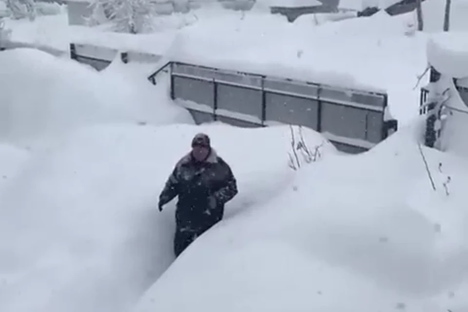
I love his professionalism, i.e. "It's business as usual! Just a tad of a windy & rough sea."Local sea captain Pyotr Osichansky, 72, said: 'It's December, and the sea is rough and windy'

I love his professionalism, i.e. "It's business as usual! Just a tad of a windy & rough sea."Local sea captain Pyotr Osichansky, 72, said: 'It's December, and the sea is rough and windy'
 www.severe-weather.eu

 www.sott.net
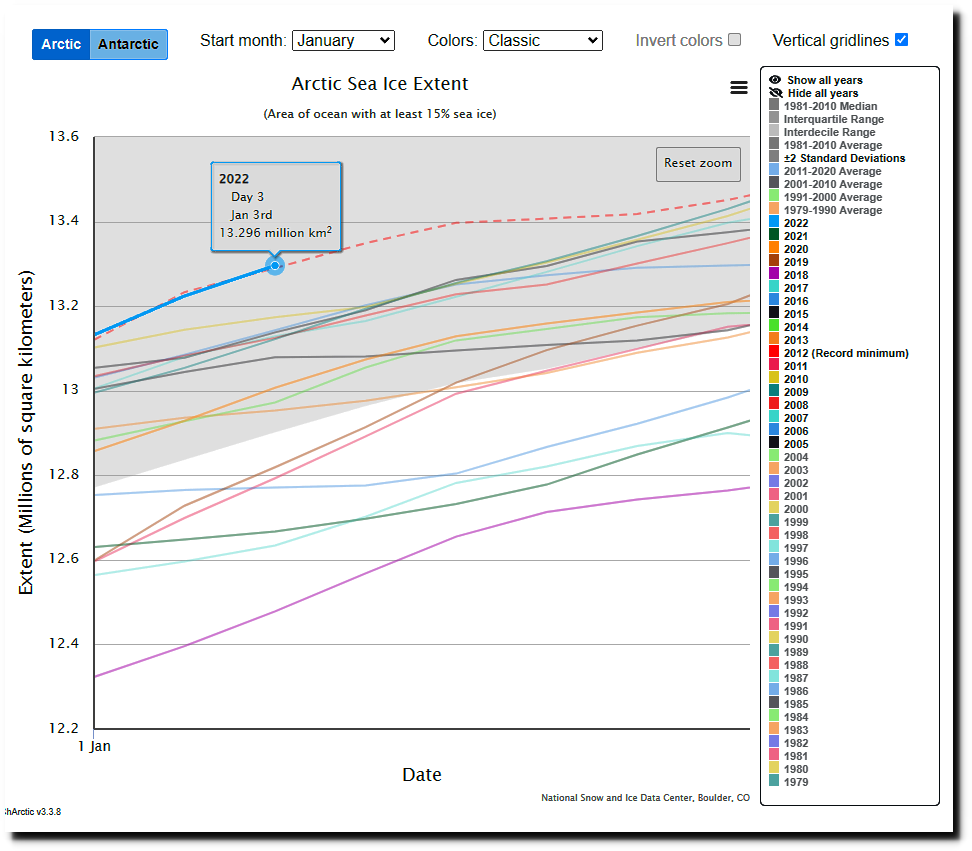
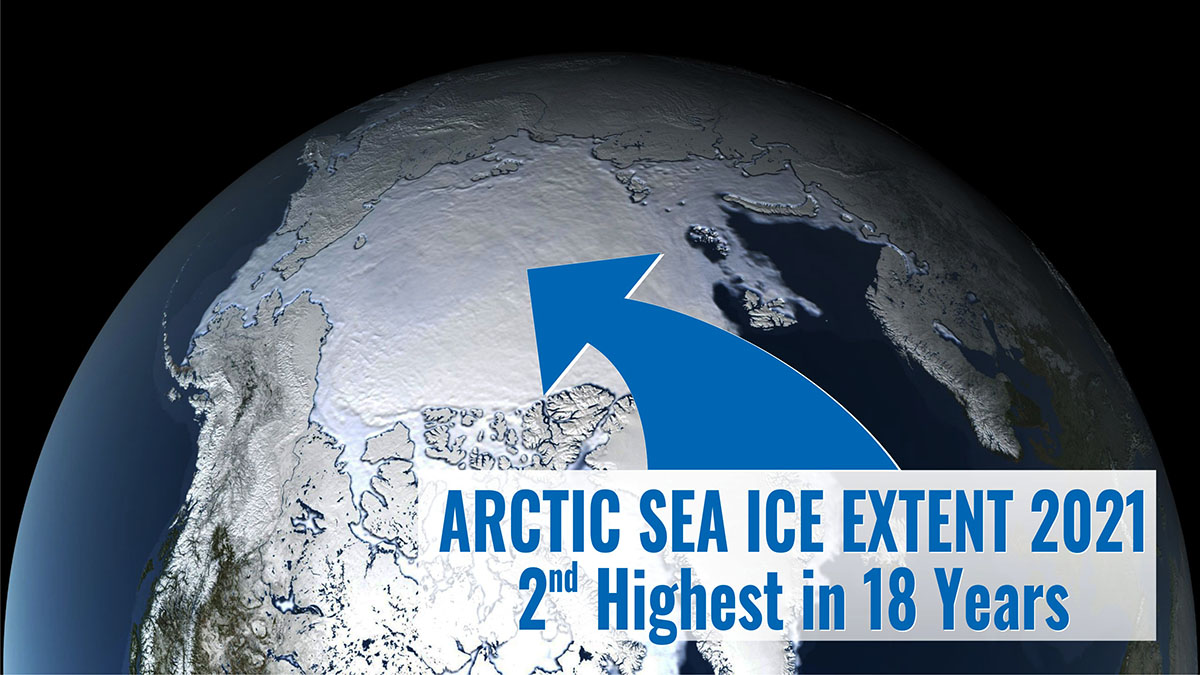
And highest in 18 years on January 3rd. Just came across this on Twitter:Arctic sea ice extent 2021 at the end of December is the highest in recent years and the 2nd highest in 18 years according to the US Snow and Ice Data Center.
Climate History Researcher: Arctic Ice Sees 18-Year High For January 3rd…Also More Ice Than 100 Years Ago!
By P Gosselin on 5. January 2022
Arctic sea ice refuses to melt…there’s more ice today in some Arctic regions than 100 years ago.
Climate science skeptic rock star Tony Heller of realclimatecscience.com presents more inconvenient data on Arctic sea ice. Ice levels are perfectly within the normal range of the past 100 years.
Arctic sea ice data reaches 18-year high for January 3rd
First Tony presents the latest data on Arctic sea ice extent for this date.
“Arctic sea ice extent is the highest in 18 years,” reports the leading manmade global warming skeptic. “The global warming scam is collapsing in real time, even as the press and government ramp up the lies.”
Image: Real Climate Science | "Science is the belief in the ignorance of the experts." — Richard Feynman
Tony also points out: “Antarctica just had their coldest six months on record,” a fact the mainstream media and government agencies have done everything to keep a lid on.
More ice today than 100 years ago
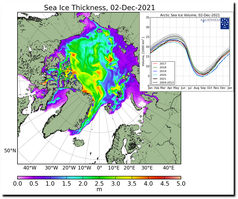
Diving deep into the newspaper archives, Tony also discovered old articles dating 100 years ago and noted in his post last month that the Arctic back then had been warming rapidly and the area of Svalbard had even been ice free.
“But there is lots of ice around Svalbard now,” Tony shows:
Image: realclimatescience.com
Unfortunately Twitter has stopped Tony from presenting these embarrassing facts and deleted his account. But you can follow him at: Tony Heller (@TonyHeller) • gab.com
When you only listen to the media, then you’ll wind wind up worrying about climate change. But when you look at the historical record and facts and compare them to today, then you’ll see things are pretty normal.
 www.sott.net
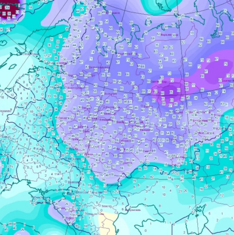
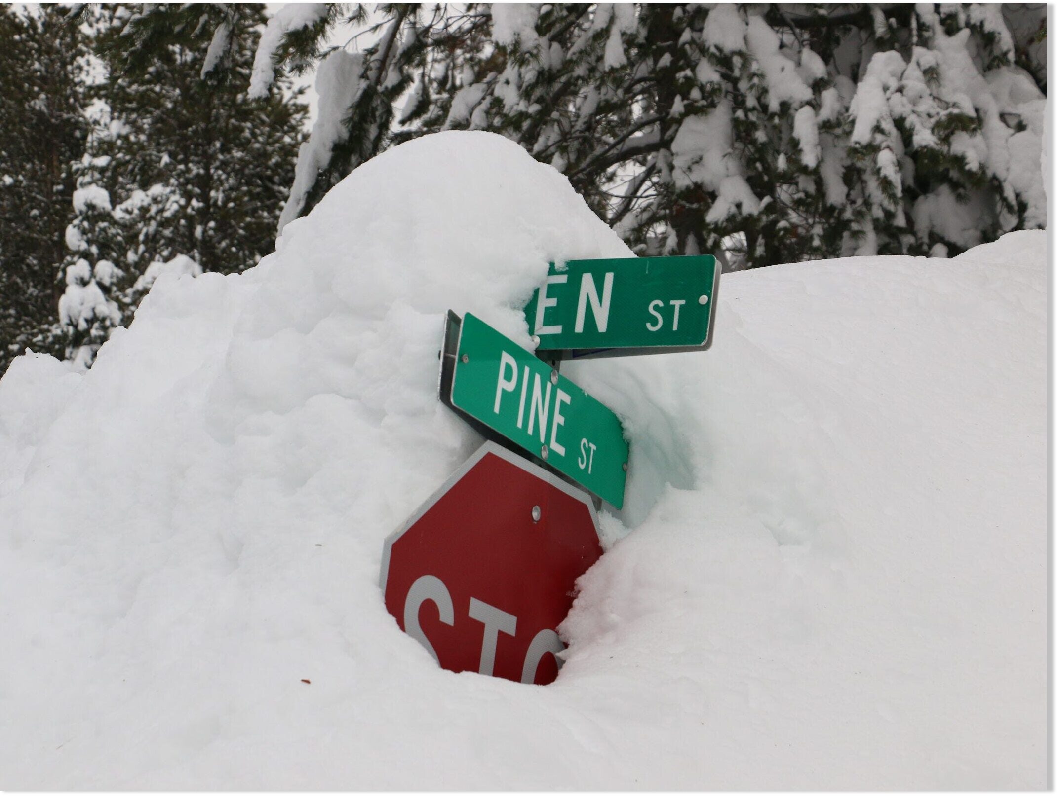
Snowfall broke daily record at Pearson for Jan. 17
Downtown Toronto had received 36 centimetres of snow by 2 p.m. on Monday, according to a summary from the Ontario Storm Prediction Centre. Ottawa, meanwhile, received 45 centimetres of snow.
The snowfall recorded at Toronto Pearson International Airport on Monday — 32 centimetres — broke a daily record for Jan. 17, according to Environment Canada. The previous daily record at Pearson was set in 1994, when 7.6 centimetres of snow fell.
The summary said the snowfall amounts reported at Toronto Pearson International Airport and Ottawa International Airport fell within the Top 10 highest snowfall totals reported in a single snowfall event.
The last time Toronto saw a storm with more than 25 centimetres was in 2019. The last time there was more than 30 centimetres was in 2008.
Toronto's largest single-day snowfall, recorded at Pearson Airport, was 45.5 centimetres in February 1965.
Ray Houle, a severe weather meteorologist for Environment Canada, called Monday's storm a "significant" weather event.
"The general consensus around here is that it was a pretty historic storm. Not very often do we get a storm that brings snowfall amounts and blizzard-like conditions like that to the Golden Horseshoe and the GTA," said Houle.
"I thought it was pretty significant — it was once-in-a-decade kind of storm."
 www.sott.net

- Type II clouds, which are very rarely observed in the Arctic, have cirriform and lenticular sub-types [9] and consist of water ice only.[4]
Only Type II clouds are necessarily nacreous[1] whereas Type I clouds can be iridescent under certain conditions, just as any other cloud. The World Meteorological Organization no longer uses the alpha-numeric nomenclature seen in this article, and distinguishes only between super-cooled stratiform acid-water PSCs and cirriform-lenticular water ice nacreous PSCs.[
Polar stratospheric clouds (PSCs) are clouds in the winter polar stratosphere at altitudes of 15,000–25,000 m (49,000–82,000 ft). They are best observed during civil twilight, when the Sun is between 1 and 6 degrees below the horizon, as well as in winter and in more northerly latitudes.[1] One main type of PSC is made up mostly of supercooled droplets of water and nitric acid and is implicated in the formation of ozone holes.[2] The other main type consists only of ice crystals which are not harmful. This type of PSC is also referred to as nacreous (/ˈneɪkriəs/, from nacre, or mother of pearl, due to its iridescence).
Yesterday (17th of January 2022), the northern regions of Scandinavia were treated to a very rare high-altitude spectacle. For about 2 hours, rare polar stratospheric clouds (PSC) type II appeared out of nowhere, displaying a staggering iridescence contrasting with the dimmer twilight of the short polar days.
PSCs are also called mother-of-pearl clouds or nacreous clouds because their iridescence (diffraction of sunlight in tiny ice particles) is some of the strongest in clouds on Earth. Their strong colors are very visible with naked eyes, making the experience surreal, almost straight out of a fairy tale. They are also some of the highest clouds on Earth, forming around 15-30km in altitude in very precise conditions, limiting their occurrence. It needs to be extremely cold up there (below 78°C), which can only be satisfied in the winter months above polar regions where the stratosphere is at its coldest. There, tiny ice particles (along with other chemicals present in type I) nucleate and form over mountain ranges because of vertical shears/strong winds to form lenticular structures (type II).
I filmed those in a rush yesterday between snow showers, as a friend gave me the heads up. I used a long focal length to really try and emphasize their iridescence. In one of the sequences, you can also see Jupiter hang above the clouds (top left corner!), as well as an airplane flying by! All was shot with the Sony a7rII at a focal length of 200-600mm (Sony). All post production was made in FCPX. I hope you like the movie as much as I liked shooting and processing it and I thank everyone of you for your support. All content is of course copyrighted Night Lights Films (except sountrack licensed through Artlist, see credits for title and artist), and no footage can be used in any way without our prior consent /permission. Please contact us at nightlightsfilms@gmail.com for media and purchase inquiry. Please share and comment if you liked the video and follow me for more videos like this one! More at nightlightsfilms.com. Thanks for watching and don't forget to subscribe!!
I heard rumours of undercounting spots in 2019, thus i guess the max would be in 2025, a year earlier. The dromedary shape comes from Jupiter and Saturnus being inline with the sun. Then the curve max would turnout lower, like 80, and activity would bottom out in 2030. Wait and see.View attachment 53827
The latest projection of sunspots in our cycle, from Suspicious Observers. You can see the sun is much more active (blue line) than what was expected (red line). So what are the implications?
The latest projection of sunspots in our cycle, from Suspicious Observers. You can see the sun is much more active (blue line) than what was expected (red line). So what are the implications?
New sunspot counts from NOAA confirm that the young solar cycle is outperforming the official forecast. You are here:
See the complete labeled plot or play with an interactive version from NOAA.Sunspot counts have exceeded predictions for 15 straight months. The monthly value at the end of December 2021 was more than twice the forecast, and the highest in more than 5 years.
The "official forecast" comes from the Solar Cycle Prediction Panel representing NOAA, NASA and International Space Environmental Services (ISES). Using a variety of leading indicators, the Panel predicted that Solar Cycle 25 would peak in July 2025 as a relatively weak cycle, similar in magnitude to its predecessor Solar Cycle 24. Instead, Solar Cycle 25 is shaping up to be stronger.
Sky watchers have already noticed the change. "We are definitely seeing the effects on the ground in the Arctic!" reports Chad Blakley of the Swedish tour guide service Lights over Lapland. "Auroras now are the best in years."
(A) The first X-flare of Solar Cycle 25 on July 3, 2021; (B) A radio blackout caused by an X-flare on Oct. 28, 2021; (C) Auroras over Wisconsin photographed by Marybeth Kiczenski on Nov. 4, 2021.Indeed, geomagnetic activity has nearly tripled since the new solar cycle began. In 2020, the first full year of Solar Cycle 25, there were 9 days with at least minor (G1-class) geomagnetic storms. That number skyrocketed to 25 days in 2021. One of those "storm days" (Nov. 4, 2021) was a borderline G4-class (severe) event with auroras sighted as far south as California and New Mexico.
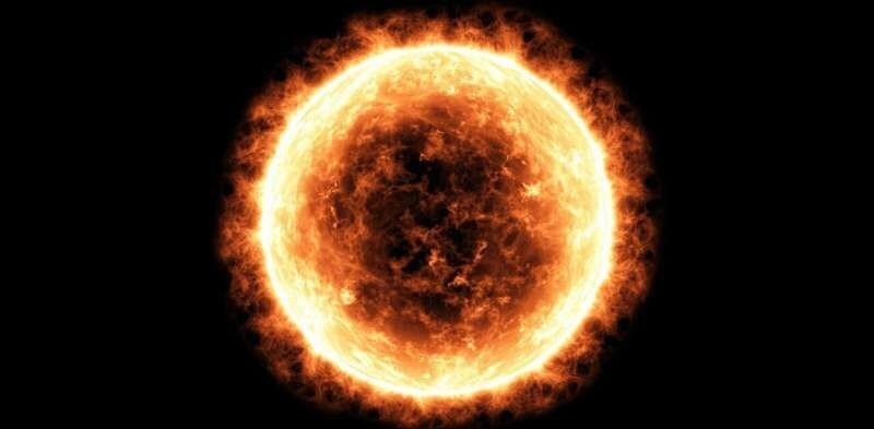
Another sign of increasing solar activity is the X-flare. X-flares are the most powerful type of solar flare. They can cause strong radio blackouts, pepper Earth's atmosphere with energetic particles, and herald intense geomagnetic storms. The sun produced zero of these flares from late 2017 until mid-2021. Solar Cycle 25 busted the drought on July 3, 2021, with an X1.6 category explosion, followed by an X1-flare on Oct. 28, 2021.
Comment:Interestingly, two particularly memorable events occurred within 24 hours of the X-flare:
- Undersea gas pipeline rupture causes fire in Gulf of Mexico (3rd July 2021)
- Huge explosion filmed in Caspian Sea, officials speculate oil rig fire or mud volcano - UPDATE: Footage of 'new island' formed in aftermath released (4th July 2021)
Two down, 98 to go? Typical 11-year solar cycles produce more than 100 X-flares during the years around Solar Max. Stay tuned for updates as Solar Cycle 25 intensifies. Solar Cycle 25 sunspot count exceeds expectations for 15 straight months - NOAA -- Sott.net
Solar Cycle 25: Is a Termination Event imminent?
Something big may be about to happen on the sun. "We call it the Termination Event," says Scott McIntosh, a solar physicist at the National Center for Atmospheric Research (NCAR), "and it's very, very close to happening." If you've never heard of...
"If the Terminator Event happens soon, as we expect, new Solar Cycle 25 could have a magnitude that rivals the top few since record-keeping began," says McIntosh.
This is, to say the least, controversial. Most solar physicists believe that Solar Cycle 25 will be weak, akin to the anemic Solar Cycle 24 which barely peaked back in 2012-2013. Orthodox models of the sun's inner magnetic dynamo favor a weak cycle and do not even include the concept of "terminators."
"What can I say?" laughs McIntosh. "We're heretics!"
The researchers outlined their reasoning in a December 2020 paper in the research journal Solar Physics. Looking back over 270 years of sunspot data, they found that Terminator Events divide one solar cycle from the next, happening approximately every 11 years. Emphasis on approximately. The interval between terminators ranges from 10 to 15 years, and this is key to predicting the solar cycle. "We found that the longer the time between terminators, the weaker the next cycle would be," explains Leamon. "Conversely, the shorter the time between terminators, the stronger the next solar cycle would be."
Example: Sunspot Cycle 4 began with a terminator in 1786 and ended with a terminator in 1801, an unprecedented 15 years later. The following cycle, 5, was incredibly weak with a peak amplitude of just 82 sunspots. That cycle would become known as the beginning of the "Dalton" Grand Minimum.
Solar Cycle 25 is shaping up to be the opposite. Instead of a long interval, it appears to be coming on the heels of a very short one, only 10 years since the Terminator Event that began Solar Cycle 24. Previous solar cycles with such short intervals have been among the strongest in recorded history.
On the 12th of Jan, Space Weather.com gave a few more details on this unexpectedly strong sun spot activity; says it is more than two times stronger than forecast; exceeding forecasts for 15 months straight; the highest in more than 5 years; aurora activity is more intense and at lower latitudes; 'geomagnetic activity has nearly tripled since the new solar cycle began'.
Whether this unexpected turn of events is due to external factors (comets - added: such as Megacomet Bernardinelli-Bernstein
/nemesis) and it will suddenly slump, i don't know.
It did however also bring to mind this prediction of a terminator event, which, whilst it may off, maybe there's something to it, since this cycle is, for now, stronger than predicted; as i think the Terminator theory proposes. I don't know enough about it to say either way, but i've included some of the details in the 2nd quote for reference for those that do have a better understanding:
Terminator event:
Polar oceanographer Andrey Proshutinsky of the Woods Hole Oceanographic Institution has labeled this anticipated surge of water a “ticking climate bomb,” noting that even a partial flush of that growing reservoir –a mere 5 percent– could temporarily cool the climate of Iceland and northern Europe. A larger outflow would actually threaten to shutdown the Gulf Stream, an event that would see ice age conditions sweep Northern and Western Europe almost overnight.
The Gulf Stream is key to Europe having the mild, habitable climate that it does.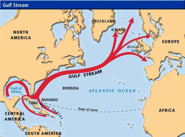
We know this occurs, and have detailed records of a relatively recent event: during the 1960s and 1970s, a surge of fresh Arctic water was released that cooled the top half-mile of parts of the North Atlantic. Known as the Great Salinity Anomaly, British oceanographer Robert R. Dickson said the event represented one of the most persistent and extreme variations in global ocean climate observed during the past century. The surge of ice and freshwater cooled Northern Europe dramatically and disrupted the North Atlantic food chain. Between 1951 and 2010, many of Europe’s exceptionally cold winters occurred during the period of the Great Salinity Anomaly.
The discussed mechanism is believed, by many, to be the ice age trigger, and a newly published scientific paper only adds further support. Entitled, “Evidence for extreme export of Arctic sea ice leading the abrupt onset of the Little Ice Age“, the new study combines marine sediment cores drilled from the Arctic Ocean to the North Atlantic. These records reveal that an abrupt increase in Arctic sea ice and cold freshwater exported to the North Atlantic starting around 1300, peaking in mid-century, and ending abruptly in the late 1300s. Crucially, the paper concludes that external forcing from volcanoes or any other cause may not be necessary for large swings in climate to occur — a previously widely held assumption: “These results strongly suggest that these things can occur out of the blue due to internal variability in the climate system,” said Dr. Martin Miles, researcher in the Institute of Arctic and Alpine Research at the University of Colorado.
The climate jigsaw continues, albeit slowly, to be pieced together.
The next bout of severe cooling is due –climate is cyclic, never linear– and the release of the Beaufort Gyre, in line with a rapidly waning magnetosphere and an intensifying Grand Solar Minimum, hold all the keys necessary.

 www.kuban.kp.ru