The Ice Age Cometh! Forget Global Warming!

Sac Bee (California)
This week's storms could drop 100 inches of snow in the Sierra Nevada
Updated March 12, 2018 12:41 PM
_http://www.sacbee.com/news/weather/article204695904.html#emlnl=Morning_Newsletter

Video: 0:33
An SUV is buried in snow at Mammoth Mountain in last week's storm. Ski resorts may rejoice more this week. Storms are expected to drop about 100 inches of snow in the Sierra, where snowpack stands at 37 percent of regular year-to-date accumulation. Mammoth Mountain "http://www.sacbee.com/latest-news/article204731189.html/video-embed"

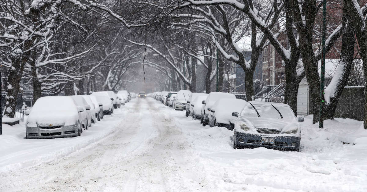
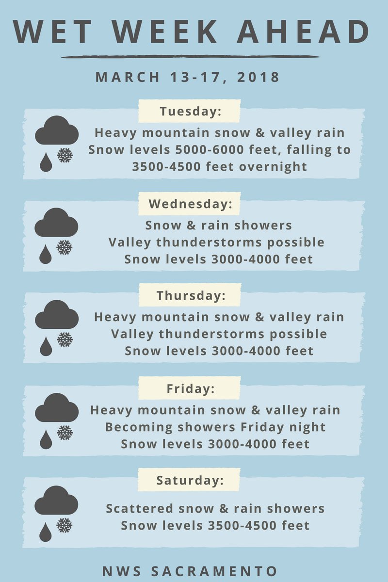
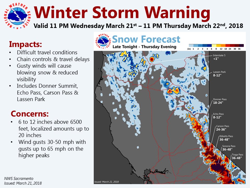
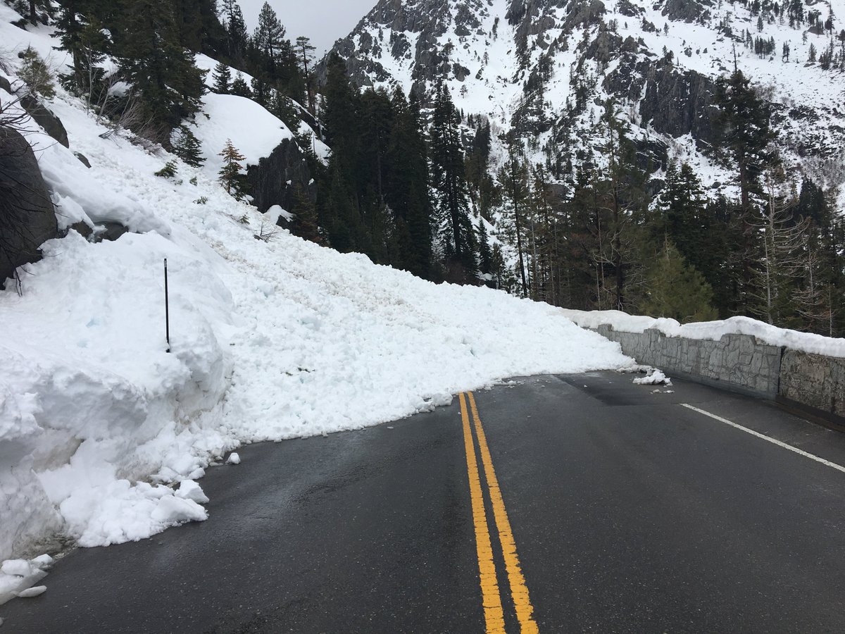
Two storms are projected to dump up to 100 inches — that's more than eight feet — of snow in the Sierra Nevada mountains Tuesday through Saturday, according to new projections from the National Weather Service.

Sacramento is expected to get two to three inches of rain by Saturday, including a half-inch to an inch-and-a-half and 20-30 MPH winds by Wednesday. The heaviest rainfall is forecast for Tuesday morning and Thursday afternoon through Friday morning.

Rain from two systems is expected to broadside Northern California this week, dropping up to seven inches in Grass Valley, five inches in Sonora and three in Chico, Redding, Santa Rosa and Weaverville by Saturday morning.

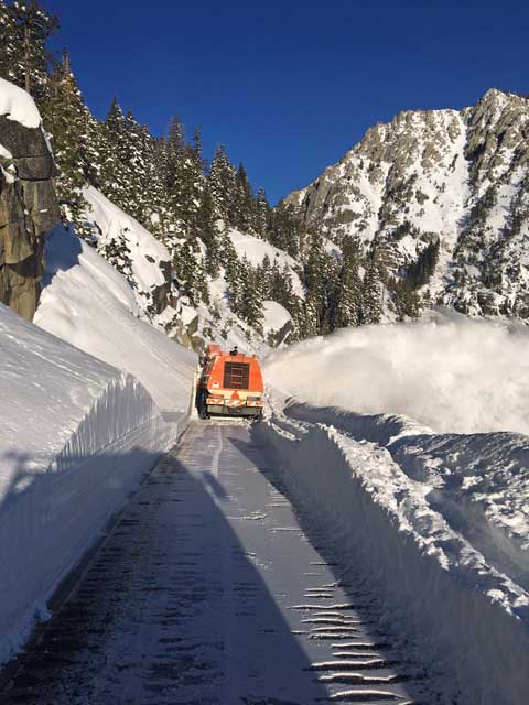
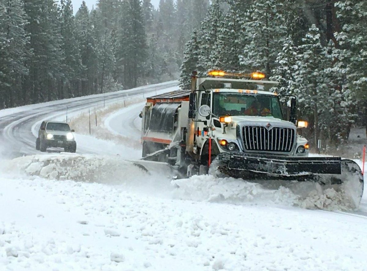
Forecasts call for about a foot of snow over most mountain passes by Wednesday, followed by another 3-plus feet and accumulation as low as 3,500 feet over the rest of the week.

The storms should add some weight to the Sierra Nevada snowpack, which is up to 37 percent of its regular year-to-date pileup after heavy snowfall at the beginning of March. National Weather Service meteorologist Eric Kurth said the absence of an atmospheric ridge means more wet weather may begin Tuesday and Wednesday of next week, though it's too early to predict precipitation totals.

"A lot of people are going to be attracted to the snow and are going to want to get up there," Kurth said. "But there's no big dry period where there's a nice window of travel. Sometimes we can tell people leave Thursday or Friday to get up to the snow, but this one is pretty consistent."

A weak system dropped three to four inches of snow over ski runs in Northstar California, Boreal Mountain Resort and Squaw Valley — Alpine Meadows over the weekend but left the rest of the Sierra virtually untouched.

NWS Sacramento
‏Verified account @NWSSacramento
DYI-W47VMAAPuST.jpg

https://twitter.com/NWSSacramento/status/973409559393001472

MM:Southern Cal.
_https://en.wikipedia.org/wiki/Mammoth_Mountain
Map: https://www.google.fr/maps/place/Mammoth+Mountain/@37.6307684,-119.041389,15z/data=!3m1!4b1!4m5!3m4!1s0x80960d2646f49e0d:0x5805dac91469afa4!8m2!3d37.6307692!4d-119.0326342?dcr=0
 
Yes, the weather is very, VERY strange this winter/Spring. It's been strange before so we need to see what happens.
 
Laura said:
Yes, the weather is very, VERY strange this winter/Spring. It's been strange before so we need to see what happens.

Check out Oppenheimer Ranch Project's calculations for the US, and including the European outlook until March 23. Ends at 8:00 min's.
It is very strange, with the recent warm trend before the Winter rebound. One day last week it hit 22*C (73*F), for a short time during that day.


https://youtu.be/IFMXMfBh8W8?rel=0
Keep out the snow shovel. Another nor'easter, 'bomb cyclone' expected
 
The US capital is shrouded in snow on March 21, 2018 amid the fourth Nor’easter to strike in less than three weeks. Winter Storm Toby is throwing a fresh blanket of snow just as spring begins.

World sees rapid upsurge in extreme weather: report Wednesday 21 March 2018
http://www.arabnews.com/node/1270996/world

A world addled by climate change has seen a four-fold increase in major flooding events since 1980, and a doubling of significant storms, droughts and heat waves, Europe’s national science academies jointly reported Wednesday.

In Europe, where precise data reaches back decades, the number of severe floods has jumped five fold since 1995, according to the report, which updates a 2013 assessment.

“There has been, and continues to be, a significant increase in the frequency of extreme weather events,” said Michael Norton, environmental program director for the European Academies’ Science Advisory Council.

“They underline the importance of avoiding greenhouse gases, which are fundamentally responsible for driving these changes,” he told AFP.

For impacts that cannot be avoided, he added, “this makes climate proofing all the more urgent.”

In the United States, the damage wrought by storms doubled, on average, from $10 billion in 1980 to $20 billion in 2015, adjusted for inflation, according to the report, based in part on data from insurance giant Munich Re’s NatCatSERVICE.

The update also assessed new findings on possible changes in the Gulf Stream, powerful ocean currents running between the Arctic region and the Caribbean that warm the air in northwestern Europe and the US eastern seaboard.

The weakening of the Gulf Stream “is now a credible hypothesis,” said Norton. “Some of the underlying drivers of extreme weather which were speculative four years ago are looking less speculative.”

The prospect of the Gulf Stream — also known as the Atlantic Meridional Overturning Circulation (AMOC) — slowing, or even shutting down entirely, “must be taken as a serious possibility,” he added.

Scientists have estimated that winters in Britain and much of western Europe would be several degrees Celsius colder under such a scenario.

The study also examined recent disruptions of the polar Jet Stream, a band of west-to-east winds that circulate at bullet-train speed some 10 kilometers above Earth’s surface at the upper boundary of the troposphere.

Recent research has linked severe winters in North America and Europe, as well some extreme summer weather, to Jet Stream fluctuations possibly driven by global warming in the Arctic, where temperatures have risen twice as fast as for the planet as a whole.

A 2016 study in Climatic Change forecast that, by mid-century, pockets of southern Europe will face at least one severe climate hazard every year of the scale now occurring only once every 100 years.

By 2100, according to these predictions, Europe’s entire Mediterranean seaboard will be confronted annually with extreme droughts, coastal floods or heat waves. And a few “hotspots” will be hit every year by two or more such formerly once-in-hundred-years hazards, which also include wildfires, river floods and windstorms.
 
Winter Storm Toby Dumps, Atmospheric River to Crush California and West Coast (557)
Adapt 2030 Published on Mar 21, 2018

https://youtu.be/sLc_YmJjOzw?rel=0

CaltransDist3
https://twitter.com/CaltransDist3/status/975772840858238976
9:35 AM - 19 Mar 2018
DYqkNo1WkAAl2bH.jpg

Our crews are working this morning on reopening Highway 89 around Emerald Bay. Check out the snow accumulation!
CaltransDist3
DYxhTb7VAAEwsZi.jpg

6:00 PM - 20 Mar 2018

NWS Sacramento
‏Verified account @NWSSacramento
https://twitter.com/NWSSacramento/status/976579890358218752
DY2Bs2IVQAA3xOC.jpg

A Winter Storm Warning has been issued for the #Sierra above 6500 feet late tonight through Thursday 11PM. Localized amounts up to 20 inches possible. Additional accumulations up to 3 feet possible Fri-Sat.

Caltrans District 3
12:08 PM - 21 Mar 2018
DY1aWmjU8AAlk2h.jpg

This is the snow slide that has 89 blocked in Emerald Bay near Eagle Point Campground. Maintenance reports it's as high as 15 feet deep and about 160 feet long.

VIDEO: How Good is Snowbird, UT on a Powder Day? Time to Find Out after 38 Inches in Four Days
SnowBrains | March 20, 2018
https://snowbrains.com/category/video/

https://youtu.be/TnRPquNFOrU

4th Winter Storm Hits NYC on 3/21/18. A View From Park Slope Bklyn / 4:41

https://youtu.be/06d-dfEUinE?rel=0
 
Yesterday this area was at 13*C (57*F). A beautiful (T-shirt weather), spring day.
At this hour were now seeing a winter squall at 2*C (37*F) with heavy snow accumulation above 518 meters.
Just so unpredictable.

GSM Update 3/30/18 - Texas Tornado - Canada Minus 40 - PNG 6.9Mag - Biblical Sandstorm /16:24

https://youtu.be/ADUzMPQZ4jM?rel=0

Snow Report 31st March 2018 Val d'Isere Tignes
Published on Mar 30, 2018

https://youtu.be/DLwowRN5hL4
Clare is here to tell us about the snow conditions this week!
It has been snowing!!!! More!!! Record Snow Levels with 8m + of snow falling this season already.


Map Val d'Isere Tignes: https://www.google.fr/maps/place/73320+Tignes/@45.474395,6.8876342,16437m/data=!3m1!1e3!4m5!3m4!1s0x47890c63287d7ebb:0x408ab2ae4baa8b0!8m2!3d45.4683226!4d6.9055785
 
April 4, 2018 - How Did a Miles-Long Crevice Appear in the Earth Overnight?
How Did a Miles-Long Crevice Appear in the Earth Overnight?

What’s going on in Africa?

An enormous crack spanning for miles opened up in the earth outside Nairobi, Kenya. The 50-feet-deep crevice that sliced through a major highway measures up to 50 feet deep and 65 feet across at its widest point.

Not only has it divided the land, but the crack is dividing scientists, who can’t quite seem to come to one conclusion as to how the natural phenomenon occurred.

Geologist Ben Andrews believes the crack is a result of tectonic plates shifting.

"We’re seeing a crack that in all likelihood formed over many thousands of years, or hundreds of thousands of years," Andrews told CBS News.

Andrews explained the crack may be one of the first pieces of evidence that a piece of Africa will break off the continent in 50 million years.

But, earthquake geologist Wendy Bohon disagrees. While she does believe that Africa will split into two in the future, she believes this crevice was caused by the weather.

“I think it’s an earth fissure, the same sort of thing you see in Arizona after heavy rainstorms,” Bohon explained. “They’re the result of heavier torrential rains that come and wash away large portions of the dirt.”

What Bohon’s theory does not explain, however, is how the crevice formed along the very point scientists have expected the continent to split.


April 4, 2018 - Breaking up is hard to do: Africa could eventually split into two continents (Video - Map)
Breaking up is hard to do: Africa could eventually split into two continents

The tear, which continues to grow, collapsed part of a highway and "was accompanied by seismic activity in the area," said Lucia Perez Diaz, a postdoctoral researcher on tectonics at Royal Holloway, a university in London.

The crack is located in a region known as the East African Rift Valley. It measures more than 50 feet in depth and 65 feet across, according to National Geographic. A rift valley refers to a lowland region where tectonic plates rift, or move apart.

The valley stretches over 1,800 miles from the Gulf of Aden in the north towards Zimbabwe in the south, splitting the African plate into two unequal parts: the smaller Somali plate and much larger Nubian plate, Perez Diaz noted.

Eventually the rift should expand and break Africa into two continents: The smaller continent will include present-day Somalia and parts of Kenya, Ethiopia, and Tanzania, while the bigger one will include everything else.

"A rift like this once eventually separated the African and South American continents to form the Atlantic Ocean, and the rift in east Africa may be the very early stages of this," said Christy Till, an Arizona State University geologist. "The process just occurs very slowly and takes millions of years."
 
Well, that's pretty awesome! I bet it will go faster than a million years!
 
Here's a video that gives a good view:


Wow! Didn’t see this. Combining all the footage recollected trough the last couple of years it really looks like a fiction movie becoming real! It is like ‘the day after tomorrow’ after all...
 
Storm to deliver unusual wintry blast of snow to Sierra in April
Wednesday, April 11, 2018
Call it winter's last hurrah. (Doubt it :rolleyes:)

A cold system is dropping down from the Gulf of Alaska Wednesday and forecast to deliver a chilly blast of air — and up to a foot of snow — in the northern Sierra Nevada.

Temperatures will drop down below freezing overnight Wednesday as the storm passes over the mountains and blasts the region with snow.

"It's late in the season for a cool system like this," says meteorologist Eric Kurth with the National Weather Service in Sacramento. "It's more of a wintry type storm, considering we're in April."

The heaviest snow will fall in the evening, and those traveling over mountain passes should be prepared for winter conditions

Donner and Carson pass could see 8 to 12 inches, while Echo and Ebbetts Pass may get 6 to 8 inches. Lassen Park is expected to record up to 18 inches of snow. Ski resorts in the Tahoe Basin could record one foot or more of fresh powder.

Temperatures will continue to dive Thursday, and snow levels could drop as low as 2,500 feet, bringing light flurries to the foothills.

Some spots in the Sierra, including Truckee, could see temperatures drop into the teens overnight Thursday.

"For people going up skiing, they should expect ski resorts to be in the 20s," says Kurth. "That's unusual for this time of year. People who are used to spring skiing conditions, you're going to have bundle up as you would in January."

Skies will clear Friday and things will warm up a little with highs in the 40s. Saturday will be clear and mild and another system is expected to hit Sunday.

"We're not done yet,"
says Kurth.

These colder systems are a stark contrast to the warmer tropical storm that drenched the Sierra last week in rain. The so-called atmospheric river brought rain to elevations as high as 11,000 feet.

Major snowstorm to evolve into blizzard, halt travel in north-central US
AccuWeather 15 Hours Ago
A major storm will bring heavy late-season snow and blizzard conditions from portions of the northern and central Plains to the Upper Midwest from Friday to Sunday night.

The area likely to receive between 6 and 12 inches of snow is forecast to extend from central Montana to northeastern Wyoming, much of South Dakota, southern North Dakota, northern Nebraska, much of southern Minnesota and northwestern Wisconsin.

Blizzard conditions are projected from much of Nebraska, South Dakota and southern North Dakota to central and southern Minnesota to northern Wisconsin.

The storm has the potential to bring 1 to 2 feet of snow to part of the same area that is likely to experience blizzard conditions.
Other major cities in the region likely to be adversely affected by the snowstorm include Sioux City, Iowa; Valentine, Nebraska; Rapid City, Huron and Pierre, South Dakota; Miles City, Montana; Ortonville, Minnesota; and Eau Claire, Wisconsin.

"At this time, the zone from Toronto to London and Windsor, Ontario, may have substantial ice storm," according to AccuWeather Senior Meteorologist Brett Anderson. "There is a risk of trees coming down and power outages in this part of southern Ontario with sleet farther north."

AAvM7vX.img

CHICAGO, USA - FEBRUARY 09: Snow covered cars are seen through the road after the blizzard in Chicago, Illinois, United States on February 09, 2018. (Photo by Bilgin S. Sasmaz/Anadolu…)
 
Apr 15, 2018 :cool2:

Latest Storm Brings Snow To Sierra, Rain To Bay Area
SF Bay Area Published on Apr 15, 2018
https://www.youtube.com/watch?v=z3QzecYOId8
 
Last edited:
For reference:
North Atlantic circulation slows down
Two or three stories were carried on SOTT summarizing these papers published in Nature. Here's one:
Is the Gulf Stream about to collapse and is the new ice age coming sooner than scientists think? -- Sott.net

Yep, helped me see the light! Thus, still stacking wood for the coming snowfall inundation.

Chemtrails? Contrails? Strange Skies -- Sott.net
Snip:
8) Now, what is wrong with the picture presented above?

Answer: the altitude of cirrus clouds vs the altitude of many jetliners that criss-cross the skies with trails which are obviously much lower than the altitude designated for cirrus clouds.

YET the trails left by these aircraft ACT like cirrus clouds used to act at much higher altitudes.

Most logical (and scariest) conclusion: the cold layer of the upper atmosphere has gotten lower and probably thicker and therefore, more airplanes flying at lower altitudes are forming contrails in that icy air which used to be the much higher domain of cirrus clouds.

Because, again, if you understand about the layers of the atmosphere, temperatures, winds, etc, then you will realize that what is happening is NOT spraying of the human population or even intentional weather manipulation, it is the EVIDENCE that our planetary atmosphere has changed dramatically in the past ten years or so.


More like 20 because that was when I began noticing the changes in cloud formation.


https://get.google.com/albumarchive...5svw8zpHPRvHOWrgS-08y?authKey=CNHblLuB6MeY5AE
 
Grand Solar Minimum and no French Connection of reality

La France creuse sa « dette écologique »:pinocchio:
Mis à jour le 04.05.2018 à 09h48
France has begun to reduce its budget deficit, but its ecological deficit continues to widen inexorably. This is the alert launched by WWF in a report released Friday, May 4. As of Saturday 5, the French will live somehow on credit: if their consumption level was generalized to the planet, all the resources that nature can renew in one year would already be exhausted.

The NGO has worked in collaboration with the Global Footprint Network, an international research institute that annually calculates the "day of overtaking": the one from which the ecological footprint of humanity - carbon emissions, use of agricultural land, grasslands, forests and aquatic environments, or the artificialisation of soils - exceeds the planet's biocapacity, ie its annual capacity to absorb greenhouse gases of anthropogenic origin and restore its reserves.

No doubt this indicator has its limits. It gives a predominant weight to carbon emissions (60% of the ecological footprint) and does not take into account factors such as the loss of biodiversity, pollution or pressure on the water resource. Nevertheless, it allows us to measure, year after year and with constant parameters, the evolution of the situation. And the trend is not good.

Whereas until the early 1970s humanity consumed fewer resources than nature could afford, it later became a debtor. And the fateful day of passing is more and more precocious: December 1 in 1975, November 5 in 1985, October 5 in 1995, August 26 in 2005, August 4 in 2015, August 2 in 2017, may - be even earlier this year, for which the Global Footprint Network will deliver its verdict this summer. In other words, it would now need 1.7 to meet the annual needs of some 7.5 billion people.

Development model

WWF has for the first time looked at the particular case of France. It appears that if the whole world lived like the French, the capacity of ecosystems to regenerate would be exhausted from May 5, in just over four months. It would therefore take 2.9 planets for oceans and forests to store CO2 released within a year from human activities, and to feed livestock and fish, or the supply of wood to the world's population.

Admittedly, France's ecological footprint is smaller, compared to the biocapacity of the national territory, in France but also in the overseas territories. With this calculation, the French consume 1.8 times more resources than "their" natural environments are able to provide. "This report does not put forward a" nationalist "approach, but points a development model that leads to a worsening of our ecological debt," says Pascal Canfin, Director General of WWF-France.

Moreover, France ranks in the leading group of the most "predatory" countries, far behind Qatar (with the Qatari lifestyle, the day of the planetary overrun would be the ... February 9), the United States, the Canada or Australia, but at about the same level as Germany and the United Kingdom, ahead of Japan, Greece or Italy. For comparison, with the way of life of Vietnam, the day of the overtaking would intervene only December 20!

In detail, carbon emissions account for more than half (56%) of the ecological footprint of the French, the use of agricultural land for food and feed (20%), logging (11%). %), the allocation of grasslands to cattle breeding (5%), fishing (4%) and land cover by industrial infrastructure, transport routes or dwellings (4%). Globally, housing, transportation and food account for more than two-thirds of the pressure on natural environments, particularly because of the greenhouse gas emissions they generate.

For the WWF, this observation is all the more alarming since the Hexagon had, over the period 2008-2015, continuously reduced its ecological footprint. It has since recovered, with a 5% increase between 2015 and 2018. A bad result mainly due to a surge in greenhouse gas emissions in the building and transport sectors.

"The paradox is that this degradation began in 2015, the year of the adoption of the Paris agreement on climate," commented Pascal Canfin. Beyond cyclical explanations, such as the decline in oil prices have favored a rise in consumption, the NGO sees evidence that the national policy of ecological transition "is not ambitious enough".
"No planet B"

"If the planet was a business, it would be bankrupt," adds its managing director. Climate disruption, the disappearance of life, the destruction of primary forests and the transformation of oceans into plastic soup are signs of this ecological failure. "

The NGO believes, however, that it is not too late to raise the bar. "Technologies are now available, whether they be electric vehicles, low-energy housing, renewable energies or organic food," says Canfin. So it's a question of political will. The President of the Republic has made good financial management a key element of his five-year term. He must now put in place an ecological debt strategy. "

And take the word Emmanuel Macron who, on April 25, in front of the American Congress, declared: "There is no planet B." In other words, there is no choice but to live with the finitude of our Mother Earth .

Adapt 2030 Ice Age Report: French climate returning to Little Ice Age conditions -- Sott.net
Adapt 2030 Thu, 03 May 2018 16:49 UTC

04 May-2°C Le Pic du Midi 2018 May

USA out Look
Published on May 3, 2018
 
Back
Top Bottom