The Ice Age Cometh! Forget Global Warming!

Whilst I do believe that the next (mini) Ice Age cometh, it seems to me that the Earth is sending chaotic, mixed messages to us. There are spots where a glacier or the snowline is retreating, (such as evidenced by the discovery of ancient hunting weapons in the above documentary), but there are other places where record-breaking, early snowfall indicates the opposite; plenty of examples of which appear in SOTT's Earth Changes column.

So, I guess we'll just have to wait and see, as the Cs often tell us.

The brief article below discusses 'swings between extremes' as the norm during a Grand Solar Minimum. There's a NASA map of the Maunder Minimum temperatures showing that certain parts in the North actually showed an overall increase in warming, over Alaska, South of Greenland, and Iceland. So there's a historical precedent for these kinda mixed messages.

Research shows “blocking” persistence increases when solar activity is low, causing weather patterns to become locked in place at high and intermediate latitudes for prolonged periods of time.

During a Solar Minimum, the jet stream’s usual Zonal Flow (a west–east direction) reverts to more of a Meridional Flow (a north-south direction).

This is exaggerated further during a Grand Solar Minimum (GSM) –such as the one we’re likely entering now– and explains why regions become unseasonably hot or cold and others unusually dry or rainy with the extremes often then flipping a dime.


Zonal flow (left) vs Meridional flow (right) — see link below for more:


Mikhaël Schwander, et al, 2017 — “The zonal flow characteristic of westerly types is reduced under low solar activity as the continental flow for easterly and northerly types is enhanced. This is also confirmed by the higher blocking frequency over Scandinavia under low solar activity.”

Schwander’s paper, “Influence of solar variability on the occurrence of central European weather types from 1763 to 2009”, goes further:

“The 247-year-long analysis of the 11-year solar cycle impact on late winter European weather patterns suggests a reduction in the occurrence of westerly flow types linked to a reduced mean zonal flow under low solar activity. Based on this observational evidence, we estimate the probability to have cold conditions in winter over Europe to be higher under low solar activity than under high activity.”

The Sun appears to be slipping into its next Grand Solar Minimum cycle–a multidecadal spell of reduced solar output where the solar disc can be devoid of sunspots for months or even years at a time.

The impact on Earth’s climate will be one of violent swings between extremes: Intense bursts of heat will linger in one area, while a teeth-chattering chill will dominate nearby — and then the regions will “switch”. It’s this unpredictable chopping and changing that will hasten the failure of our modern food production systems; crops will fail, on a large scale, and famine will quickly ensue.

Overall, Earth’s temperature trends colder during a GSM as the Sun’s output sinks lower and lower (increasing cloud nucleation, being one factor); however, not ALL regions experience the chill. As with the previous GSM (the Maunder Minimum 1645-1715), areas such as the Arctic, Alaska, and southern Greenland/the North Atlantic actually warm during bouts of otherwise “global” cooling.

NASA reveals the phenomenon in their Maunder Minimum temperature reconstruction map:

Temp change between 1780 (a year of normal solar activity) and 1680 (a year within the depths of the Maunder Minimum) — NASA.

Earth’s climate is cyclic, never linear — and history repeats.

Once again, the Arctic appears to be warming, but in line with the historically low solar activity we’re experiencing and its effect on the jet stream, not due to human prosperity (i.e. Man’s CO2 excretions).
 
We received pea-sized hail and some snow yesterday here in the mountains just before the winds started blowing at around 50mph and the temperature plummeted about 40 degrees. We went from about 40 degrees to -1 with a wind chill of -28 from yesterday afternoon to today. Winds will continue to blow from the east, gusting anywhere from 32 to 43 mph for the next several days. My sister in Nebraska said they are to get up to 9 inches of snow.
 
Storm dumps 4 FEET of snow in parts of Wyoming - Cheyenne sets record low of -19


MMMMMM
The latest Arctic front to blast Wyoming put to rest any thoughts of an early spring as multiple feet of snow fell in at least three counties and sub-zero temperatures broke at least one record in the state on Wednesday and Thursday morning.

Carbon County was the gold medal winner for snowfall on Wednesday as 48 inches of snow was recorded at Battle Lake while campgrounds along Jack Creek and Sugar Loaf each received 42 inches.

Locations in Yellowstone National Park and Teton and Lincoln counties all received snow in excess of two feet.

The most snow in Cheyenne was in the northern areas with only 5 inches, but a 129-year record was broken when the temperature hit 19 degrees below zero early Thursday. The old record was set in 1894 at minus 13.


Other snowfall of note include areas around the south entrance of Yellowstone, which received 34 inches; Teton Village recorded 29 inches; followed by Etna and Moose Wyoming both with 25 inches; while Alta, Moran Junction and Turnerville all got 23 inches of snow.

Areas around the Hog Park Reservoir in Carbon County received between 20 and 23 inches of snow.

Other areas in Lincoln County that received an abundance of snow includes: 18 inches in locations near Smoot, 17 inches in areas outside of Cokeville and 17 inches near Thayne.

In Fremont County, snowfall up to 15 inches was recorded 7 miles north-northwest of South Pass City while areas southwest of Lander received between 11-15 inches. Riverton recorded 8.8 inches.

In north-central and northeast Wyoming, Story received the most with 16 inches, followed by 15 inches east of Shell and 13 inches west of Buffalo. Gillette recorded 9 inches of snow while Wright had 6 inches.

On or around Interstate 80, Rawlins and Lyman both received 11.5 inches of snow, Elk Mountain received 10.2 inches while communities near Interstate 25 received anywhere from 12 inches of snow near Casper to 7 inches in Wheatland.

Meanwhile, windy weather brought severe wind chills across the Cowboy State.

In the tiny town of Hiland, Wyoming in Natrona County, wind speeds clocked in at 73 mph. Green River recorded a 69 mph gust while Rock Springs had gusts up to 66 mph.

Snow drift currently blocking WY28 north
© WYDOT
Snow drift currently blocking WY28 north of Farson.


Snowfall totals surpass 5 FEET in some areas of southern California with nearly 7 FEET at Mountain High

Crestline, California, inspected the heavy snowfall
Heavy snowfall in Crestline, California

Over the past few days mountain areas have experienced high snowfall totals and there's more on the way.

A winter storm with an atmospheric river that made its way over the Pacific brought multiple days of unexpected snowfall to some parts of Southern California.

Some areas have already received over 30 inches of snow and there is more coming in the forecast.

The snow came as the National Weather Service issued a rare blizzard warning for the San Bernardino mountains as well as the LA County and Ventura County mountains.

The storm will continue to make appearances throughout the remainder of the weekend and forecasters say another storm is already making its way expected to hit on Tuesday.

The snowfall and ice has caused multiple roadway closures due to dangerous driving conditions.

Here are some of the top snowfall totals across different counties in Southern California through Saturday morning. Measurements are in inches.

Mountain High: 81

Mt Baldy: 38

Lake Arrowhead: 36

Big Bear Lake: 33

Wrightwood: 32

Yucaipa Ridge: 19

Forest Falls: 19

Angelus Oaks: 16

Oak Grove: 2

Apple Valley: 0.25

To see more snowfall totals use this link.

The storm was fueled by a weather phenomenon behind some of California's wettest and most destructive storms. Atmospheric rivers are long plumes of moisture over the Pacific Ocean that tend to move through the atmosphere in streams between 250 and 375 miles wide.

The rivers in the sky move a staggering amount of water. One atmospheric river can move an average of 10.5 trillion gallons of water per day.

The strongest atmospheric rivers can move anywhere between seven and 25 times as much water as the flow of the Mississippi River, which is the second longest river in North America and has a watershed that reaches 32 states, according to the national park service.
 
Last edited:

Traffic Chaos: All Roads Closed Between Dalmatia and Interior​


February 26, 2023 - From 14:30 onwards, due to meteorological conditions, there is no free road direction for any group of vehicles from the direction of Dalmatia towards the interior and vice versa, reports HAK/Index.hr.

Winter road maintenance is in progress, so there are frequent delays behind winter service vehicles, which move more slowly.
...


All roads between Dalmatia and the interior are closed. "We wait in line for hours"​


12 minutes ago
PHOTO This is what the highway near the Sveti Rok tunnel looks like
At the Sveti Rok tunnel, drifts of snow have formed, and the photos show the situation at 18:50.
e42704e1-44c1-440b-bc16-280f702723c6.jpg


31 minutes ago
"General collapse, crowd and accident in Radučić"
In Radučić near Knin, there was a queue due to snow and a traffic accident, reports a reader of Index. "General collapse, crowd and accident in front of us in Radučić. We are 18 km from Gračac, but we cannot pass because of the weather and, of course, people standing in the opposite traffic lane."
84f7f267-c9a4-40c9-9ccb-0ea26b0cd608.jpg

4cda3169-a415-4e19-abc5-c9851b1d8c21.jpg


38 minutes ago
"We wait in line for hours, we can't get to the reception center"
Index is contacted by readers who are stuck on the roads.
"A pile of cars has been waiting in line for three hours at the address Otrić 62, 23440 Gračac. It looks like everyone will spend the night in the cars. After strong requests to HAK to send a plow or help to help us get to Gračac, where the reception center is open, they received We are informed that they are only an information center and that the services are doing their job. It looks like we will all spend the night in the snow on the road," writes the reader.
We were also contacted by a reader who was on the D1 road, 18 km from Gračac, just before 6 p.m. "There is a plow a few meters in front of us, but we have no information why it is standing with us in the column," he says.
e303f3d0-8ea0-4766-8ccc-5bc41e4dce2b.png


An hour ago
Open reception center in Gospić
A reception center for travelers stuck in traffic has been opened in GRAČAC, at the address Nikola Tesla 37, near the bridge, the Directorate of Civil Protection of the Republic of Croatia reported, since traffic between Dalmatia and the interior is currently stopped due to the storm.
The reception center in Gospić, Miroslava Kraljevića 19 (area of the City Sports Hall), is also available to travelers, where, along with refreshments, there is also the possibility of accommodation.


An hour ago
This is what the entrances to the Sveti Rok tunnel currently look like
80b23e4a-9384-4409-9548-f536b2d15465.jpg

8bee5888-c25c-4c51-9500-a43d437ac5f1.jpg


An hour ago
Reception center opened in Gračac for passengers stuck in traffic
In Gračac, a reception center for passengers stuck in traffic has been opened, at Nikola Tesla 37, near the bridge.


Winter conditions on the A6
Winter conditions on the A6 Rijeka-Zagreb between Kikovica and Bosiljevo II junctions. A gale blows along the coast, occasionally with storm and hurricane gusts. Certain ferry, catamaran and boat lines are suspended.
HAK advises drivers to adapt their speed and driving style to the road conditions, maintain a safe distance between vehicles and do not set off without appropriate winter equipment.
2b882091-5727-44fe-83be-cc2d74054885.jpg

c4229cc4-6f75-4c96-896e-0cb40b12b1d5.jpg


2 hours ago
It is snowing near the Sveti Rok tunnel, visibility is low
7cb82c3b-e4df-47b7-8e65-075b0439e517.jpg

52e52022-2318-477a-9702-9a59a01a74fc.jpg


2 hours ago
HACK: There are a large number of vehicles at the rest areas, do not start the road towards Dalmatia and vice versa
Until further notice, there is no free road direction for any group of vehicles from the direction of Dalmatia towards the interior and vice versa, reports HAK. Due to the large number of vehicles that have already been excluded from traffic at rest areas and parking places, we advise you not to travel on the specified route.


...
 
Apart from Mallorca being hit by snow (also reported on SOTT), Barcelona is also covered with snow:

BARCELONA UNDER SNOW, RED ALERT ISSUED IN MALLORCA

Descending Arctic air into Central and Western Europe has delivered snow to the likes of Barcelona:


Aemet has also issued an incredibly rare red alert for Mallorca, Spain’s largest Balearic Island in the Mediterranean, with heavy snow–as much as 50 cm (1.64 ft), and freezing lows–below -2C (28.4F) hitting the Tramuntana Mountains — with the snow line falling to a historic 100 m (328 ft).


The snow has led to many road closures across Spain.


And across central and western Europe, temperatures are holding well-below the norm which has been the case throughout February. I can attest here in central Portugal, where I’ve taken to heating my polytunnel with tea light heaters in order to protect my tender starts.


Following Fridays record-breaking surface mass balance (SMB) gains, the Greenland ice sheet has been at it again.

Monday, February 27 saw the sheet gain another 9 gigatons:

[DMI]


ANTARCTICA COOLS

Antarctica is cooling — the data is clear and undeniable.

Any ice loss at the ‘bottom of the world’ is due to circulation patterns (i.e. winds) within the Antarctic vortex–which is particularly strong (and cold) this year. These winds are driving sea ice offshore and into the oceans — the ice is not melting due to human prosperity (i.e. CO2 emissions) as the establishment would have us believe.

–It can’t be: Antarctica has been exceptionally cold in recent years, posting its coldest-ever coreless winter (April-Sept) last year, and routinely holding below monthly averages and busting a string of low temperature records ever since.

As recently as Monday, February 27, Dome Fuji, a Japanese Base station in Antarctica, dropped to -58.1C (-72.6F). This is now the lowest global temperature in February 2023, usurping the historically frigid -57.9C (-72.2F) logged at Oymyakon, Siberia earlier in the month.
 
Winter storms continue to dump humongous amounts of snow in California with still more in the forecast. Report for the last few days of February -


Residents of Soda Springs, California, are dealing with an estimated 36 feet of snowfall this winter, with more predicted on the way.

A string of back-to-back winter storms have lashed the West this week, delivering blizzard conditions and heavy snowfall to many areas in California.

The days long brutal conditions left many stranded, shut down highways, knocked out power to thousands of homes and buried roads in snow as communities ran low on supplies.

Last week, the National Weather Service in Los Angeles issued its first blizzard warning since 1989. Over the weekend, the weather service's local office in San Diego issued its first-ever blizzard warning for the San Bernardino County mountains

Blizzard warnings remain in effect Wednesday across the Sierra Nevada Mountain Range, where up to 2 feet of additional snowfall are possible through Wednesday morning.

The San Bernadino Mountain Range could see between 1 and 3 feet of additional snowfall, with gusts up to 75 mph.


Here are some of the highest snow totals over the past day

Palisades Tahoe, California: 38 inches


Soda Springs, California: 36 inches

Central Sierra Snow Lab, California: 36 inches

Homewood Mountain, California: 36 inches

Kirkwood Meadows, California: 30 inches

Twin Bridges, California: 28 inches

Northstar, California: 27 inches

Tahoma, California: 27 inches

Mt. Rose Ski Base, Nevada: 20 inches

Mammoth Mountain, California: 20 inches

Washougal, Oregon: 18 inches

West Cape Horn, Oregon: 17 inches

Portland Airport, Oregon: 7.5 inches

Here are some of the highest snow totals over the past 2 days

Soda Springs, California: 52 inches

Kirkwood Meadows, California: 43 inches

Twin Bridges, California: 39 inches

Kingvale, California: 36 inches

Donner Peak, California: 36 inches

Brighton Crest, Utah: 33 inches

Teton Village, Wyoming: 28 inches
 
Winter storms continue to dump humongous amounts of snow in California with still more in the forecast. Report for the last few days of February -

Yes sir. We're only at about 2400ft elevation and received upwards of 2 feet yesterday. Up to our knees. Certainly a record which will likely go unreported. 🙄 
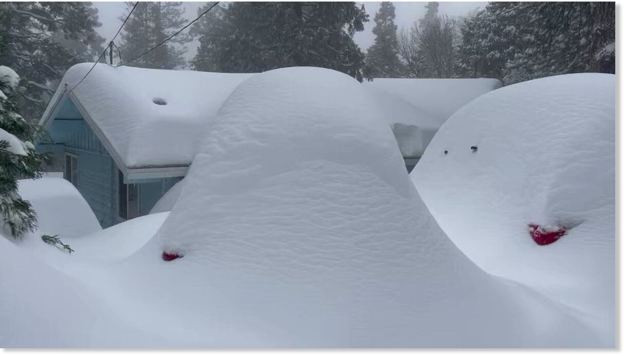
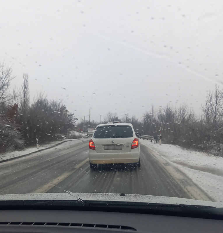
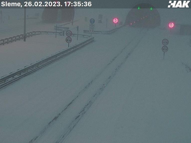
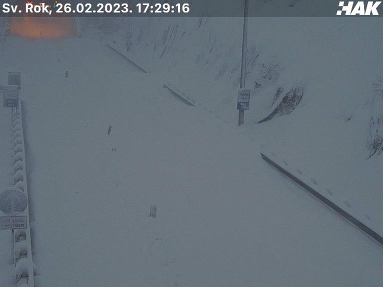
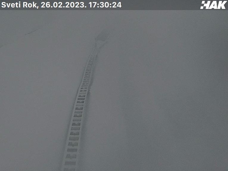
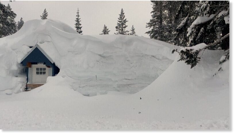
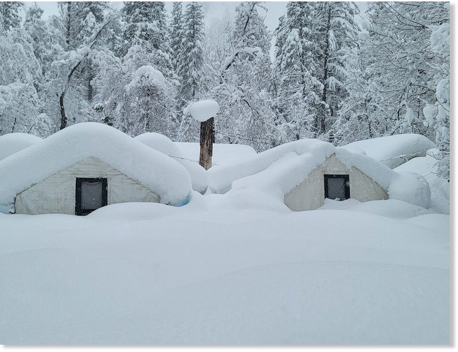
Have never seen so much in 24 hours in the 10+ years we've been here.

It made the morning walk with the "where'd she go?" mini Aussie quite humorous.
 
Last edited:

BARCELONA UNDER SNOW, RED ALERT ISSUED IN MALLORCA

Descending Arctic air into Central and Western Europe has delivered snow to the likes of Barcelona:

Snow | Barcelona / Balearic Islands

Here you can see the satellite chart (1) from yesterday 28 Feb 2023, which marks the snow showers which got pulled down over East Spain and the Baleares due to a cyclone near by.

Today (2) this system has moved to Italy, and shows - in my opinion - shows a light signature that of a sub-tropical storm (eye) which often is called "Medicane".

SAT_1_2023022811_44.jpg

SAT_1_2023030118_44.jpg
 
Yosemite National Park breaks decades-old snowfall record, closing national park indefinitely - snow 15 FEET deep after recent storms

nnnnnnnnnn
Cabin roofs at Yosemite National Park are almost completely covered with snow. At the park's Badger Pass ski area, snow is up to the second floor of the lodge. In the Yosemite Valley, snow accumulation broke a 54-year-old daily record — by multiple inches.

The historic snowfall in the Sierra Nevada from back-to-back winter storms has closed the world-famous park indefinitely while rangers and park staffers work to respond to the epic snowpack.

"In all of my years here, this is the most snow that I've ever seen at one time," said Scott Gediman, a spokesperson for Yosemite and ranger for 27 years. "This is the most any of us have ever seen."

The park known for its impressive granite formations and stunning waterfalls initially announced Saturday it would close because of severe winter weather, with plans to reopen by Thursday. But after additional snowfall though early Wednesday, officials for the national park announced it would remain closed, without a specific date to reopen.


As of late Tuesday, officials measured 40 inches of snow in the Yosemite Valley — among the park's lowest elevations — setting a record for the date, Gediman said. The previous record on the valley floor had been set at 36 inches on Feb. 28, 1969.

Park officials said up to 15 feet of snow had fallen in some higher-elevation areas in recent days, making travel extremely dangerous, if not impossible.

"Over the past week or so, here in Yosemite National Park, along with the Sierra Nevada, [we have] been receiving record amounts of snowfall," Gediman said.

Images shared from across the park show snow almost completely blocking a doorway, covering park buildings with several feet of snow and evidence of a likely avalanche.

"There's just a huge amount of snow everywhere," Gediman said.

The park's ski area hasn't had decent snowpack for the last five years or so because of the drought, he said, but as of Wednesday, snow is up to some of the chair lifts and the second floor of the lodge.

Experts say this year could bring record snowfall for parts of California.

A blizzard warning for the entire Sierra Nevada remains in effect through 4 p.m. Wednesday, following days of such extreme conditions. Up to 6 additional feet of snow were possible from this week's winter storm, as well as wind gusts up to 75 mph, the warning said.

That new snowfall comes on top of the significant accumulation from the last storm, which dumped fresh powder on the park Friday and Saturday. It's hard to say which band brought in more snow because there was little time between the two systems, Gediman said, but both were significant.

Clearing the roadways and keeping staffers safe are the park's main priorities right now, as well as clearing the snow load off roofs, getting in additional supplies and restoring power, Gediman said. Yosemite has reported no injuries from the storms.

"What we're doing is literally taking it one day at a time," Gediman said, unable to give an estimate for reopening.

"We're just digging out and doing the best we can to remove the snow and get the park ready for visitors in a safe manner."
 
With all these record snowfall in California and Nevada, to mention just those two states, it's hard not to imagine the mayhem when all that snow eventually melts...
If they get a big soaker along with the snowmelt, it could trigger huge floods. The amount of water soil can hold if it’s properly managed with things like regenerative ranching is vast, otherwise the water runs overland causing enormous destruction. As an example in Africa from Allan Savory, they had roughly the same amount of rain fall on both his land and some neighboring land, the river on his property rose 2-3 feet, on the neighboring land it was somewhere around 12 feet.

The conditions largely determine the destruction and we’ve been creating conditions conducive to destruction for some time.

You could look at the destruction from Hurricane Katrina in the same framework. Years of cutting channels through the Mississippi River delta essentially eroded lots of barrier islands and reduced the ability to absorb the storm surge, so there was massive destruction. Lots of it can be chalked up to ignorance of how Nature works…. Might tie that into the recent comment of the C’s about psychic health and overpopulation. Can you ever be psychically healthy and be ignorant of Nature’s cycles?
 
With all these record snowfall in California and Nevada, to mention just those two states, it's hard not to imagine the mayhem when all that snow eventually melts...
Traditionally the snow melts slowly over the course of spring and into summer, keeping the streams and rivers full (and salmon/trout happy). The rain, at least until April, is at lower elevations. The mountains will still be getting snow. Ideally.

Reality is there have been so many wildfires that many areas (think many thousands of acres) are no longer forests and like Ben's Delta analogy, abosorbtion has changed. The tree roots are no longer there to hold the hill/mountain side stable either. Good chance of lots of mudslides, I would guess.

The upside is, the long-lasting drought may soon be over. And I'd wager the skiing is top-notch. 😎
 
Last edited:
Due to the copious amounts of precipitation across California of late a once large lake seems set to reappear.


Return of Tulare Lake: Farmland impacted as lake basin fills in Kings County, California


Tulare Lake, drained decades ago, may return after California’s record-breaking storms

Tulare Lake, drained decades ago, may return after California’s record-breaking storms.


In Kings County, floodwater is now covering a large area of agricultural land in the Tulare Lake Basin.

The water levels are something we haven't seen in nearly four decades.

The winter of 1982-83 was the last time we saw water going into the Tulare Lake basin.

That's because that water is diverted to the San Joaquin River.

However, an increased flow in all waterways leading to the basin has caused Tulare Lake to begin to reemerge.

The lake was known in the late 1800s as the largest fresh water lake in the western United States.


mmmmmmmm
"This isn't a one time this isn't a two-day this isn't a two week event. This will last through the summer most likely around September," explained Kings County Sheriff David Robinson.

In response to huge snowfall amounts within the Kings River watershed, the U-S Army Corps of Engineers began a flood release into the old Tulare lakebed to create room in the Pine Flat Reservoir.

"We have a lot of farmers that farm in the lake bottom and they understand that we get an event like this perhaps a 100 year event some of their land will flood again," Robinson said.

"So, there's a pretty good start on the on the lake's reconfiguration this year, how much will be there," said Randy McFarland with the Kings River Water Association. "Well, time will tell as it goes on. Kind of depends on how how hot the weather is early on."

McFarland says the 1,000 square mile lake hasn't filled since the winter of 1867 and 68.

mmmmmmm
That's when water levels reached 207 feet above sea level.

"There is a high point of land in the northwest corner of the lake, it was able to go over and flood into the eventually into the San Joaquin River," McFarland explained.

It would dry up for the first time in 1898 as canals were dug from various rivers to irrigate farm land.

A home video from 1942 shows the lake's return after it was revived by heavy runoff from the mountains.

The lake remained at a quarter of its size for three years.

"Caused a a lot of grief in Kings County and Western Tulare County. Then again in 1968-69, when we had a huge water year, and in 1982-83," said McFarland.

An 1876 map of Tulare County shows Corcoran would be underwater.

Kettleman City and Lemoore would be lake front, and Alpaugh would be an island.

"The Alpaugh area, actually Alpaugh, was an area known as Atwells Island. It was a little bit higher," McFarland said.

As for the latest re-emergence of the Tulare Lake and how long we'll see it, McFarland says there is no natural outflow for the water.

"After it gets there, then it. The only way it's going to be eliminated is through evaporation, or what irrigation can take place," McFarland said.

The Kings County Sheriff is reminding everyone the Tulare Lake Basin is private farm land and trespassing rules will be enforced.
Video also on SoTT page.
 
Last edited:
Back
Top Bottom