Not just Europe suffers an unusually cold month of May, also the US:
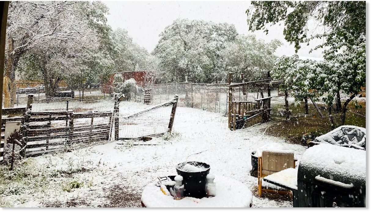
A historic and long-duration snowstorm is set to unleash feet of powder on the higher elevations of Montana, Idaho, Wyoming, Oregon and Washington state this week, with unprecedented inches settling at lower-elevations, too.

AccuWeather meteorologists say that snowfall of this volume over such an extensive area is highly unusual.
Daily high temperatures have plummeted a whopping 40-60 degrees Fahrenheit from their Monday peak, and could tumble even further as the weekend approaches:
Canada:
Large parts of British Columbia, Alberta and Saskatchewan are also on for impressive totals through the remainder of the month:
 GFS Total Snowfall May 19 – May 31 [tropicaltidbits.com].
A return to near-zero temperatures was observed overnight, a stark contrast to the daytime highs of 30C (86F) witnessed this past weekend (another example of the Grand Solar Minimum and the Swings between Extremes).
North America’s unprecedented May chill doesn’t look to be shifting anytime soon:
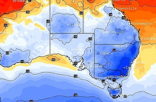
Australia:

Swathes of Australia are shivering through a record-breaking cold snap, with the frosty mornings set to continue across eastern parts through the weekend.
In addition, not only was this the city’s (Sidney's) coldest run of May nights in 54 years, it was “the coldest run of nights this early in the year in 66 years,” a Bureau of Meteorology spokesperson said.
 electroverse.net
And India:
India’s capital city Delhi usually experiences scorching temperatures in May.
Yesterday, however, a high of just 23.8C (74.8F) was registered — the city’s coldest May reading since 1951, and one some 16 degrees Celsius below the seasonal average.
The recent rains have also been record breaking.
According to the India Meteorological Department, the previous 24-hour rainfall record for the month of May was the 60mm received back on May 24, 1976. But Wednesday, May 19, 2021 just busted that benchmark.
 electroverse.net
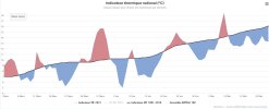
“2021 European Cold Spring Does Not Mean Climate Change Is Fake,” reads a recent Forbes headline.
I like what Cap says: "But surely, by now, in the year 2021, if ‘Catastrophic Global Heating’ was indeed a real thing, shouldn’t it be more obvious? Genuinely, why hasn’t the constant need for the theory to be pointed out to people become redundant?"
A historic and long-duration snowstorm is set to unleash feet of powder on the higher elevations of Montana, Idaho, Wyoming, Oregon and Washington state this week, with unprecedented inches settling at lower-elevations, too.
AccuWeather meteorologists say that snowfall of this volume over such an extensive area is highly unusual.
Daily high temperatures have plummeted a whopping 40-60 degrees Fahrenheit from their Monday peak, and could tumble even further as the weekend approaches:
Canada:
Large parts of British Columbia, Alberta and Saskatchewan are also on for impressive totals through the remainder of the month:
 GFS Total Snowfall May 19 – May 31 [tropicaltidbits.com].
A return to near-zero temperatures was observed overnight, a stark contrast to the daytime highs of 30C (86F) witnessed this past weekend (another example of the Grand Solar Minimum and the Swings between Extremes).
North America’s unprecedented May chill doesn’t look to be shifting anytime soon:
Australia:
Swathes of Australia are shivering through a record-breaking cold snap, with the frosty mornings set to continue across eastern parts through the weekend.
In addition, not only was this the city’s (Sidney's) coldest run of May nights in 54 years, it was “the coldest run of nights this early in the year in 66 years,” a Bureau of Meteorology spokesperson said.
Record Breaking Cold Blasts Australia and Canada: "GLOBAL" Cooling - Electroverse
Not since the year 1967 has Sydney experienced a colder streak in May. Grand Solar Minimum and Pole Shift.
And India:
India’s capital city Delhi usually experiences scorching temperatures in May.
Yesterday, however, a high of just 23.8C (74.8F) was registered — the city’s coldest May reading since 1951, and one some 16 degrees Celsius below the seasonal average.
The recent rains have also been record breaking.
According to the India Meteorological Department, the previous 24-hour rainfall record for the month of May was the 60mm received back on May 24, 1976. But Wednesday, May 19, 2021 just busted that benchmark.
Delhi, India Suffers Coldest May Day in 70 Years + Earth has COOLED 0.8C since 2016 - Electroverse
This COOLING trend is expected to accelerate over the coming months and years as the Sun continues its relative shutdown. Prepare. GSM.
“2021 European Cold Spring Does Not Mean Climate Change Is Fake,” reads a recent Forbes headline.
I like what Cap says: "But surely, by now, in the year 2021, if ‘Catastrophic Global Heating’ was indeed a real thing, shouldn’t it be more obvious? Genuinely, why hasn’t the constant need for the theory to be pointed out to people become redundant?"