That is a rogue wave. Very impressive one.Insane extreme weather numbers across the planet as the world transfixes with the White House exacerbating the Russian news with ly's.
If we are to believe the readings from the Seaford Newhaven buoy, the maximum wave height recorded at 1:30 p.m. reached more than 31mWhen passing a low pressure trough like #Eunice , the maximum wave height can indeed be 2.5x+ higher than the significant height.
You are using an out of date browser. It may not display this or other websites correctly.
You should upgrade or use an alternative browser.
You should upgrade or use an alternative browser.
Crazy Storm Weather and Lightning - Global
- Thread starter mabar
- Start date
Thanx CA! Just came back from that at the same time..
My 13yo daughter wanted to go and even went down to the water.
It was the windiest place in the Netherlands. F9/10. Dozens of weather worshipers.
We've seen worse and safety glasses help out in the sandblastzone.
My yurt is holding out fine, went up a bit only a couple of times.
Last edited:
Some footage from the Netherlands during the storm (Eunice) yesterday: uprooted trees, a falling tree that almost hit a car, falling containers, flying roof tiles and what seems to be flying solar panels:
In total, four people died. Two people (pedestrian and a cyclist) died because a tree landed on them. The third person died as a tree landed on the car s/he was in. The fourth person crashed his car against a tree that was lying on the road.
In total, four people died. Two people (pedestrian and a cyclist) died because a tree landed on them. The third person died as a tree landed on the car s/he was in. The fourth person crashed his car against a tree that was lying on the road.
UK weather warnings - Met Office
www.metoffice.gov.uk
The latest storm follows on from a week in which Storm Dudley and Storm Eunice also impacted the UK, although wind gusts from Storm Franklin are expected to be lower than Eunice which triggered two Red Weather Warnings.
Northern areas of Northern Ireland are covered by an Amber Wind Warning that will be in force from early Monday morning. Within the Amber Warning area, winds could be in excess of 80mph in exposed coastal areas, but more widely between 60 and 70mph. Damage to buildings is possible, and there’s likely travel disruption.
An extended Yellow Warning for wind which covers much of the rest of the UK, except the northeast, has also been issued for Storm Franklin. Within the yellow warning area, wind gusts will be 65-75mph in coastal areas, and more widely 50-60mph further inland. The coasts of the northwest of England and the southwest of Scotland could see gusts of up to 75mph for a short period on Sunday night and early Monday morning.
The centre of Storm Franklin will track eastwards over the north of Scotland from early Monday morning, with the highest winds expected on the southern flank of the system. The centre of Storm Franklin will clear into the North Sea on Monday morning, although high winds will continue to be felt for most through Monday, as is reflected in the Yellow Weather Warning.
Met Office Chief Meteorologist Andy Page said: “Following the significant impacts of Storm Eunice on Friday, Storm Franklin will bring further high winds for many late on Sunday and into Monday, although not on the same scale as Eunice.
“Coastal areas of Northern Ireland, especially on that north coast, will get the strongest wind gusts, which could be around 80mph in a few places. Amber and Yellow Wind Warnings have been issued, and people should remain cautious ahead of the system that will bring 50-60mph wind gusts for much of the UK from late on Sunday and through Monday.”
A Yellow Weather Warning is also in force in the northwest of England, with heavy rain expected through much of Sunday.
Some associated snow is possible for many in Scotland and the north of England late on Sunday and into Monday. The highest accumulations will be in the high ground, adding to existing lying snow in many of these areas, although snow is also possible in some lower ground in the north.
RAC Breakdown Spokesman Rod Dennis said: “Drivers will be glad to see the back of Storm Eunice but it looks like conditions on the roads will remain challenging right through the weekend. With winds still strong and gusty, it’s important drivers don’t take any chances, so we urge them to slow down and leave plenty of space between themselves and the vehicle in front.
“It’s not just strong winds that they’ll need to contend with – on Sunday intense rainfall becomes a feature making driving arduous. If conditions get particularly bad again, people should consider postponing their journeys, and for those who have to drive, it’s vital they keep their wits about them at all times.”
People are advised to check their local resilience authorities for ongoing safety advice around travel and preparations.
For more information on how to prepare for severe weather, please visit our WeatherReady advice.
Attachments
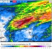
Max hurricane the last 24 hours -possibly a new Icelandic record- Max gusts in Iceland last 24 hrs: 75.6 m / s - Vatnsskarð Eystra (unverified national record) 59.63 m / s - Ásgarðsfjall 57.53 m / s - Seyðisfjörður (Vest.d) 53.12 m / s -Gagnheiði 53.01 m / s - Stórhöfði
 #Dudley , #Eunice , #Franklin 3 storms in a few days over Europe.
  Why?
Why?  Is it exceptional?
  #Thread

 Ambleteuse (62) @infoclima
NOAA Satellites @NOAASatellites
11:19 AM · Feb 22, 2022·
Europe's #Meteosat8 is monitoring #TropicalCycloneEmnati as it approaches landfall today. It is the fourth tropical cyclone to affect Madagascar over the last month. This #TimelapseTuesday, we’re showing #Emnati’s track from Feb 20 to today.
GerWeather @DECGNwx
1:30 PM · Feb 22, 2022·
At least 34 tornadoes have been confirmed across Germany in 2021. Investigation is still going on for more than 20 possible cases so the final numbers should be released sometime in March. The strongest tornado of the year: This F2 tornado that struck Berumerfehn in August. 1/2
Published Feb. 22, 2022 10:17 AM PST | Updated Feb. 22, 2022 10:17 AM PST
NOAA Satellites @NOAASatellites
11:19 AM · Feb 22, 2022·
Europe's #Meteosat8 is monitoring #TropicalCycloneEmnati as it approaches landfall today. It is the fourth tropical cyclone to affect Madagascar over the last month. This #TimelapseTuesday, we’re showing #Emnati’s track from Feb 20 to today.
GerWeather @DECGNwx
1:30 PM · Feb 22, 2022·
At least 34 tornadoes have been confirmed across Germany in 2021. Investigation is still going on for more than 20 possible cases so the final numbers should be released sometime in March. The strongest tornado of the year: This F2 tornado that struck Berumerfehn in August. 1/2
More than 100 vehicles crash in pileups amid mammoth winter storm
By Zachary Rosenthal, AccuWeather staff writerPublished Feb. 22, 2022 10:17 AM PST | Updated Feb. 22, 2022 10:17 AM PST
Major flood breaks levee and inundates Lismore, NSW, Australia.
Day turns into night in Ayolas, Paraguay:
A mysterious event took place in the city of Ayolas, Misiones, when in broad daylight at 1:00 p.m. on Monday night fell, surprising the inhabitants of that town.
It was like an apocalyptic movie when suddenly the city of Coratei, Ayolas, was left in the dark because of electrical storms that also brought the ashes that are caused by the forest fires that are recorded in the area.
Local authorities explained that this phenomenon was due to the arrival of a storm, but the ashes of the fires and the clouds caused the strange event.
This is wild! I don't think I've seen so much lightning in such a short time.
Pretty cool: '
Lightning strike up close and personal at the Indonesian Grand Prix.' - from yesterday.
Lightning strike up close and personal at the Indonesian Grand Prix.' - from yesterday.
Last edited:
Is this plasma?
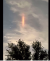
What was that mysterious vertical red light in the Houston sky?


Five months ago it was seen a similar vertical red light over Oaxaca México
What was that mysterious vertical red light in the Houston sky?
The answer? We don't know.
What we do know is we started getting reports of the light at about 8:30 p.m. Wednesday. As of 9:15 p.m., the light appeared to be gone.
For what it's worth, we did get a message from a LyondellBasell plant in La Porte saying the plant was undergoing activities that would result in periodic flaring.


KHOU 11 Meteorologist Tim Pandajis and and Chief Meteorologist David Paul both said the clouds were very reflective on Wednesday night, so the light very well could have been from the flaring.
Pandajis also said the light resembled something called a red sprite. The problem with that theory is that red sprites usually appear in groups and are usually positioned over active thunderstorms. He said that's likely not the case with this light.
Five months ago it was seen a similar vertical red light over Oaxaca México

