▪︎Reykjanes Ridge update
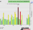
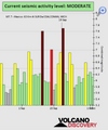
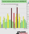
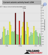
On September 29th earthquake swarm continues in Reykjanes Ridge. According to USGS data 14 earthquakes so far. Four earthquakes with magnitude 5 or higher.
M4.9 at 00:38:28 (UTC)
M4.6 at 02:06:46 (UTC)
M5.1 at 02:24:00 (UTC)
M5.0 at 04:08:23 (UTC)
M4.8 at 04:45:07 (UTC)
M4.6 at 05:38:52 (UTC)
M4.8 at 06:36:03 (UTC)
M4.7 at 06:58:37 (UTC)
M4.7 at 07:50:12 (UTC)
M4.7 at 08:14:52 (UTC)
M5.1 at 09:55:58 (UTC)
M4.7 at 12:16:39 (UTC)
M4.8 at 15:11:02 (UTC)
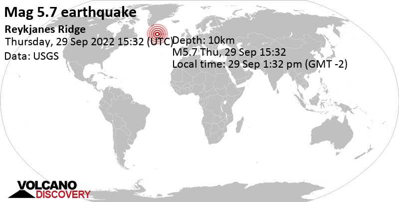
M5.7 at 15:32:30 (UTC)
53.747°N 35.192°W. 10.0 km depth.
Estimated energy released: 5351 tons of TNT or 0.3 atomic bombs
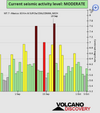
On September 29th earthquake swarm continues in Reykjanes Ridge. According to USGS data 14 earthquakes so far. Four earthquakes with magnitude 5 or higher.
M4.9 at 00:38:28 (UTC)
M4.6 at 02:06:46 (UTC)
M5.1 at 02:24:00 (UTC)
M5.0 at 04:08:23 (UTC)
M4.8 at 04:45:07 (UTC)
M4.6 at 05:38:52 (UTC)
M4.8 at 06:36:03 (UTC)
M4.7 at 06:58:37 (UTC)
M4.7 at 07:50:12 (UTC)
M4.7 at 08:14:52 (UTC)
M5.1 at 09:55:58 (UTC)
M4.7 at 12:16:39 (UTC)
M4.8 at 15:11:02 (UTC)
M5.7 at 15:32:30 (UTC)
53.747°N 35.192°W. 10.0 km depth.
Estimated energy released: 5351 tons of TNT or 0.3 atomic bombs
Data for the same earthquake reported by different agencies
Info: The more agencies report about the same quake and post similar data, the more confidence you can have in the data. It takes normally up to a few hours until earthquake parameters are calculated with near-optimum precision.| Mag. | Depth | Location | Source |
| 5.7 | 10 km | Reykjanes Ridge | USGS |
| 5.7 | 10 km | REYKJANES RIDGE | EMSC |
| 5.7 | 10 km | Reykjanes Ridge | RaspberryShake |
| 5.9 | 0.8 km | Reykjanes Ridge [Sea] | INGV |
| 5.1 | 10 km | Near Reykjavík | RENASS |
| 5.8 | 10 km | Reykjanes Ridge | GFZ |
| 5.7 | 10 km | Reykjanes Ridge | IRIS |
| 5.8 | 10 km | Reykjanes Ridge | GeoAu |
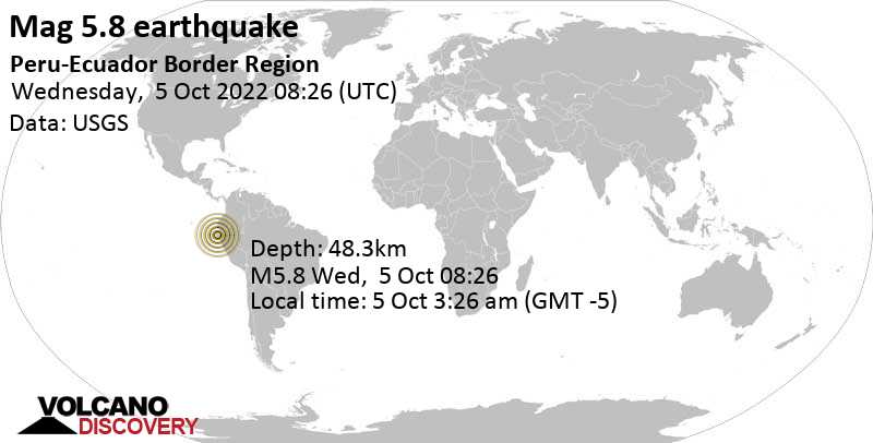
Quake info: Strong mag. 5.7 earthquake - North Atlantic Ocean on Thursday, Sep 29, 2022 at 1:32 pm (GMT -2)
Detailed info, map, data, reports, updates about this earthquake: Strong mag. 5.7 earthquake - North Atlantic Ocean on Thursday, Sep 29, 2022 at 1:32 pm (GMT -2) -
www.volcanodiscovery.com