You are using an out of date browser. It may not display this or other websites correctly.
You should upgrade or use an alternative browser.
You should upgrade or use an alternative browser.
The Ice Age Cometh! Forget Global Warming!
- Thread starter Gaby
- Start date
Yes...as I recall Bill Gates wants to block out the sun as well.Will the public blame the Elite for the Ice Age because of their experiments? A better way will be a collective understanding of the Cosmic-Human connection and how it functions. Either way, it seems that sooner or later the masses will turn against the Elite.

As I recall, Russian scientists predicted back in 2016 that we were headed towards an ice age.Saw this on Twitter recently, and it reminded me of the title of this thread!
It's the cover of Radio Times, a British TV/Radio supplemental, from November 1974.
Like other counterpoints being made by 'climate change' skeptics these days, it was tweeted to make the point that the current 'heatwave apocalypse' hysteria pushed by the media is just that - hysteria. Specifically, the current hysteria, whereas this 'older hysteria' from the 1970s was just an earlier iteration of one long stream of media-promoted hysteria about 'the weather'.
Is it though?
You might be referring to the Russian Astrophysicist Dr. Habibullo Abdussamatov who said it in 2014 and has repeated it since as far as I know.As I recall, Russian scientists predicted back in 2016 that we were headed towards an ice age.

Russian scientist: 'The new Little Ice Age has started'
Featured in new skeptical global warming book: New Book: Evidence-Based Climate Science: 'Data Opposing CO2 Emissions as the Primary Source of Global Warming' Chapter 17: Astrophysicist Dr. Habibullo Abdussamatov, Head of Space Research...
New paper by Russian solar physicist by Habibullo Abdussamatov predicts another Little Ice Age within the next 30 years
You may be referring to this article posted on SOTT about a study presented in 2015, predicting a 60% drop in solar activity in the 2030s which would lead to the same conditions that were experienced during the Maunder Minimum, the most severe part of the Little Ice Age.As I recall, Russian scientists predicted back in 2016 that we were headed towards an ice age.
Edit: just saw Aeneas’ post above, that might be the one, and his predictions are even more dire for what is about to come.
Yes, this was the fellow!You might be referring to the Russian Astrophysicist Dr. Habibullo Abdussamatov who said it in 2014 and has repeated it since as far as I know.

Russian scientist: 'The new Little Ice Age has started'
Featured in new skeptical global warming book: New Book: Evidence-Based Climate Science: 'Data Opposing CO2 Emissions as the Primary Source of Global Warming' Chapter 17: Astrophysicist Dr. Habibullo Abdussamatov, Head of Space Research...www.sott.net

DreamGod
Jedi Master
World Economic is in the process of collapse (2 years tops), Energy supply (Oil and gas) is in process of collapse in Europe (Months) and then more contries (Months/next year) depending on their needs from outside sources. That beside the weather problem.I had a dream last night where some sort of discussion was going on and I don't remember much except that it was stated that everything would collapse in two years. I had the impression that this was due to the total collapse of the weather, i.e. full bore ice age in progress. For what it's worth.
Just found this article in the PNAS, its premise is of course AGW. But the interesting part is the justification for the research, which is the evaluation of truly catastrophic scenarios, which they call "Climate Endgame".
Reading through, the study names four consequences of extreme climate change, which they call the "Four Horsemen":
On this last point, they expand a bit:
On another interesting point, the study acknowledges the need to revisit history and learn from it.
I thought it was curious this sort of analysis would come from such a big publication, they know something is coming and fast.
Reading through, the study names four consequences of extreme climate change, which they call the "Four Horsemen":
There are many potential contributors to climate-induced morbidity and mortality, but the “four horsemen” of the climate change end game are likely to be famine and undernutrition, extreme weather events, conflict, and vector-borne diseases.
On this last point, they expand a bit:
On another interesting point, the study acknowledges the need to revisit history and learn from it.
Prehistory and history should be studied to determine not just how past societies were affected by specific climate hazards but how those effects differ as societies change with respect to, for example, population density, wealth inequality, and governance regime. Such framing will allow past and current societies to be brought under a single system of analysis (37).
I thought it was curious this sort of analysis would come from such a big publication, they know something is coming and fast.
For what its worth Farmers' Almanac's winter prediction and also NOAA's - perhaps not surprisingly at odds with each other.
-------------------------------------------------------------------------------------------------------------------------
Farmers' Almanac declares parts of US 'hibernation zone' with predicted 'glacial, snow-filled' winter
![Farmers-Almanac-Winter-Weather-Forecast-US-2023-media-1-copy[1].jpg Farmers-Almanac-Winter-Weather-Forecast-US-2023-media-1-copy[1].jpg](https://cassiopaea.org/forum/data/attachments/45/45187-0b0bb53ec0812f2d56cc853d0f969873.jpg)
Many Americans have been broiling through an above-average summer, but if the Farmers' Almanac winter forecast is right, some parts of the nation are heading for a polar opposite experience this winter.
Their annual whimsical forecast is hinting at a particularly harsh winter across much of the North with "real shivers" that "might send people in the Great Lakes areas, Northeast and North Central regions hibernating."
In fact, their forecast map declares much of the upper Midwest a "Hibernation Zone" with a "glacial, snow-filled" winter head with temperatures forecast to drop as cold as -40 in the North Central states in mid-January which would be near record territory for some cities (such as Fargo, North Dakota) if such forecasts came to pass.
While temperatures wouldn't be that cold in the Northeast, the Almanac is predicting "significant shivers" there. Even in the Southeast, whose forecast isn't particularly snowy, is still looking at a "shivery, wet and slushy" winter, according to the Almanac.
As for the Southern Plains, expect the brunt of winter to come in January, with heavy snow predicted in the first week of 2023 in Texas and Oklahoma.
If shivering is not your thing, head west. The Almanac forecasts continued drier than normal conditions across the parched Southwest and Intermountain West while the Pacific Northwest is tabbed as "brisk" but with normal precipitation. That would make for a wet winter as "normal" winter is the wettest time of the year up there.
NOAA: Agree to disagree on winter forecast
Which is predicting a greater-than-average chance of a warm winter across the Southwest, Southern Plains and the entire Eastern Seaboard.
On the other hand, it's the Pacific Northwest leaning toward another chilly winter.
The Farmers' Almanac's shiver-fest forecast is in conflict with NOAA's current winter forecast.
XPan
The Living Force
Just found this article in the PNAS, its premise is of course AGW. But the interesting part is the justification for the research, which is the evaluation of truly catastrophic scenarios, which they call "Climate Endgame".
On the same paper
"Climate Endgame • Exploring catastrophic climate change scenarios"
also participated (among other) Swedish Johan Rockström, now working at the Potsdam Institute for Climate Impact Research outside of Berlin. In the Swedish Alternative media, he is known to be one of the worst Climate Change fear mongers with his extreme scare articles and blatant climate lies channeled via DN.se and SvD.se (two of the leading mainstream newspapers in Sweden)

On a different note

I found that little note from a 2009 Swedish article which I remember back then, was so strange. Pär Holmgren, was one of our most beloved TV meteorologists for many years, uttering something which felt so... out of alignment strange (even for a politically totally asleep guy like me back then)
He said: "I would quickly eliminate all elections"
TV-Meteorolog Pär Holmgren, nowadays top candidate for the Green Party for the EU parliament, answered 2009 to the question, what he would do if he would become Swedish Prime minister.


US Sees First Winter Storm Warning of the Season - SnowBrains
Winter has sent us a postcard in the mail. It’ll be visiting soon. The US got its first winter storm warning of the season last Friday as close to a foot of snow has been forecasted to fall in northern Alaska. AccuWeather reports that on early Friday morning the National Weather Service in...
US Sees First Winter Storm Warning of the Season
Winter has sent us a postcard in the mail. It’ll be visiting soon.
The US got its first winter storm warning of the season last Friday as close to a foot of snow has been forecasted to fall in northern Alaska. AccuWeather reports that on early Friday morning the National Weather Service in Fairbanks, Alaska, issued a winter storm warning in the Brooks Range and a portion of the Alaskan North Slope. It’s the first winter storm warning to be issued anywhere in the United States this snow season, which officially began on July 1.
Yes, we know this was issued in Alaska, whic may feel like the North Pole to you, especially if you’re currently experiencing warm and dry conditions with temperatures near or over 100ºF, like much of the U.S. this summer. But that’s still a winter storm warning no matter how you look at it—it’s a sign of what’s ahead. Before anyone knows it they’ll be seeing winter storm warnings in their areas at home and winter will have arrived. Only a few more months.
The forecasted snow in the Brooks Range is expected to fall in higher terrain above 2,000 feet while some areas about 4,000 feet could see up to a foot of snow or more through Sunday, according to AccuWeather. The last winter storm warning for the US was issued on June 15 in northern Montana. Although it’s extremely unlikely that any part of the continental U.S. will get snow this month, August marks the last month of meteorological summer, meaning that meteorological autumn will kick off on Thursday, September 1. Not long after that, it’ll be winter, and you know what that means.
In Arctic sea ice news and analysis - NSIDC they wrote on August 2, that the East Siberian Sea is unlikely to become free of ice this year.
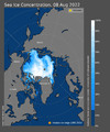
And the ice in the east is still there today a week later:The seasonal decline in Arctic sea ice extent from mid-July onward has proceeded at a near average pace. Extent is currently well below average, but above that observed for recent years. Extent is particularly low in the Laptev Sea sector, but ice extends to near the shore further east. Depending on weather conditions, the southern route through the Northwest Passage may become open. An area of low concentration ice persists over the central Arctic Ocean, extending to near the North Pole, and Antarctic ice extent is still at a record low.
While Russia makes use of the Northern Sea route year-round, over the past decade, this coastal route has become nearly or completely ice-free in late summer. Given the extensive ice in the East Siberian Sea, it seems unlikely that this will be the case in 2022. By contrast, as assessed from Advanced Microwave Scanning Radiometer 2 (AMSR2) satellite data, the southern route through the Northwest Passage, known as Amundsen’s route, may open in the next few weeks, depending on weather conditions.

The following informative map might be of interest if such a scenario were to materialize. (With 1 inch of rain equaling 10 inches of snow)
---------------------------------------------------------------------------------------------

 snowbrains.com
How Much Snow Would The U.S. Get if All Precipitation Fell as Snow?
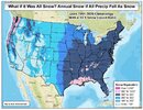
What it would look like if all precipitation was snow. Credit: Joe Lauria FOX 4 meteorologist
Have you ever looked outside when it’s raining and thought “if it was just colder, it would be snowing.” If you love snow sports, then you probably have.
The picture above from meteorologist Joe Lauria answers the question of how much snow would fall if all precipitation fell as snow. The results are pretty impressive.
Most impressive is the Pacific Northwest where some places would get over 1,000 inches per year. Mt Baker, WA, actually recorded over that amount one winter and is still the most snow ever recorded on earth.
Also impressive is the Gulf Coast area as well as almost the entire eastern half of the United States.
One interesting observation is the western US would generally get less total snowfall than the rest of the country in this hypothetical scenario. However, the mountains in these areas tend to get the most actual snowfall.
---------------------------------------------------------------------------------------------

How Much Snow Would The U.S. Get if All Precipitation Fell as Snow? - SnowBrains
Have you ever looked outside when it’s raining and thought “if it was just colder, it would be snowing.” If you love snow sports, then you probably have. The picture above from meteorologist Joe Lauria answers the question of how much snow would fall if all precipitation fell as snow. The...
How Much Snow Would The U.S. Get if All Precipitation Fell as Snow?

What it would look like if all precipitation was snow. Credit: Joe Lauria FOX 4 meteorologist
Have you ever looked outside when it’s raining and thought “if it was just colder, it would be snowing.” If you love snow sports, then you probably have.
The picture above from meteorologist Joe Lauria answers the question of how much snow would fall if all precipitation fell as snow. The results are pretty impressive.
Most impressive is the Pacific Northwest where some places would get over 1,000 inches per year. Mt Baker, WA, actually recorded over that amount one winter and is still the most snow ever recorded on earth.
Also impressive is the Gulf Coast area as well as almost the entire eastern half of the United States.
One interesting observation is the western US would generally get less total snowfall than the rest of the country in this hypothetical scenario. However, the mountains in these areas tend to get the most actual snowfall.
Last edited:

Up to 4 feet of snow dumped during 3-day storm at ski resort in Argentina
It's been storming here at Cerro Catedral for the past 3-days. Fierce storming at times with 1-inch diameter snowflakes - or clumps of snowflakes - coming down hard. The mountain has been more or less closed for 3-days due to fierce winds and...
-----------------------------------------------------------------------
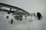
It's been storming here at Cerro Catedral for the past 3-days.
Fierce storming at times with 1-inch diameter snowflakes - or clumps of snowflakes - coming down hard.
The mountain has been more or less closed for 3-days due to fierce winds and avalanche danger.
Somewhere around 3-4 feet of snow had already fallen by the time we awoke today.
It's even been snowing in town to the tune of around 6″ the past 2-days which, in general, is a rarity here.
Last edited:
August snowfall in Kazakhstan and judging from the video more than just a dusting.
------------------------------------------------------------------------------------

 www.sott.net
![220818131015286e[1].jpg 220818131015286e[1].jpg](https://cassiopaea.org/forum/data/attachments/45/45988-50e0ceee90adeaa9c18c3b3812f5bea5.jpg)
First snow fell at a height of 1,870 m above sea level in the city of Ridder, East Kazakhstan, the ridder.city Instagram account reads.
The fog was expected to blanket the north of the region today. Ground frosts are forecast for the east, and northeast of the region in the nighttime, the emergency situations department of East Kazakhstan said. High wind is also set to sweep through the region locally, it said in a statement.
------------------------------------------------------------------------------------

Early snowfall in Ridder, East Kazakhstan -- Sott.net
First snow fell at a height of 1,870 m above sea level in the city of Ridder, East Kazakhstan, the ridder.city Instagram account reads. The fog was expected to blanket the north of the region today. Ground frosts are forecast for the east, and...
![220818131015286e[1].jpg 220818131015286e[1].jpg](https://cassiopaea.org/forum/data/attachments/45/45988-50e0ceee90adeaa9c18c3b3812f5bea5.jpg)
First snow fell at a height of 1,870 m above sea level in the city of Ridder, East Kazakhstan, the ridder.city Instagram account reads.
The fog was expected to blanket the north of the region today. Ground frosts are forecast for the east, and northeast of the region in the nighttime, the emergency situations department of East Kazakhstan said. High wind is also set to sweep through the region locally, it said in a statement.

