The Ice Age Cometh! Forget Global Warming!


toplita

Thermal waterfall in Toplita frozen for the first time in recent years

Updated: 28/01/2022

Thermal waterfall in Toplita, central Romania, frozen for the first time in recent years. Although this rarely happens, the recent negative temperatures during the night had led to the freezing of the thermal waterfall. Water curtains turned into unreal lacework.
A monument of nature, the Toplita thermal waterfall is a unique geological ecosystem, stretching over 500 square meters in the Mures river meadow.

Famous for its beauty, the waterfall was formed by limestone and travertine deposits, brought in by the thermo-mineral waters over hundreds of years.

The road to the waterfall is not easy at all, but tourists say that the stunning scenery created by the waterfall is worth the effort.

The Toplita thermal waterfall was declared a natural monument, a protected area of national interest and a biological and landscape nature reserve 22 years ago.

 
Difficult to say, since we somehow compare apples with oranges. One should aware that predictions are just that and they are often subjected to multiple revisions, like for the Solar Cycle 24 (see image below). Researchers notice spikes relative to the projected Solar cycle 25, but these spikes are going to be less prominent when compared to the actual Solar cycle 25, since it outperforms they predictions.


View attachment 53991

Seems the peeps at Space Weather are commenting on the similarity to the previous solar cycle too, which they say then turned out to be the 'weakest solar cycle in a century':

SOLAR CYCLE 25--A DIFFERENT POINT OF VIEW: For much of the past year, the space weather community has been buzzing about the strong performance of young Solar Cycle 25 (SC25). Every month, sunspot numbers seem to blow past official predictions. This means we're about to have a strong Solar Maximum, right?​


"Not so fast," cautions Dr. Ron Turner, an analyst at the ANSER research institute in Virginia. "It may be too early to anticipate a strong solar cycle."​


This graph shows why Turner is skeptical:​


Solar Cycle 25 is doing something interesting. It is mimicking old Solar Cycle 24 (SC24). "I took sunspot numbers from the early years of SC24 (the red dashed line) and overlaid them on SC25," says Turner. "They're an almost perfect match."


This is significant because Solar Cycle 24 went on to become the weakest solar cycle in a century. Its hot start did not lead to a strong maximum. Turner isn't saying that Solar Cycle 25 will likewise be a dud. But, rather, "these early sunspot numbers are not enough to guarantee a strong cycle."​


Déjà vu, anyone?​
 

This is a video that provides some insights on how past Ice age and thunderbolts resulted in mass extinction.

Peter Mungo Jupp: Mass Extinction Thru Cosmic Force | Thunderbolts​


Peter Mungo Jupp January 22, 2022 - 4:00 pm Multimedia


Siberia, Alaska, and Malta are three examples of mass slaughter sites littered with carcasses and skeletons either petrified in rock, invaded in limestone, entombed in bitumen, buried in ice or mummified in peat bogs. Their instantaneous end was horrific. What agent of destruction rendered them extinct?
Archaeologist Peter Mungo Jupp unravels the evidence embraced in petroglyphs, art, writings, verbal traditions—even dance motifs—that cosmic thunderbolts may have been the force behind some of the world’s mass extinction events.

 
Last edited:
California drought continues to grow with intensity.

Meanwhile:

Filed in Weather/Climate Discussion by Daniel Swain on February 4, 2022 Snip (Graphs and Charts)

Record dry January for portions of CA and NV (but thank goodness for “Bombtober”)

Well, I don’t need to tell most folks twice: January 2022 was an exceptionally dry month across most of California and Nevada. Some spots saw a bit of rain and snow during the first couple days of the month, but others saw nothing at all; the last 25 days of the month brought essentially zero precipitation to the entire region. As a result, January 2022 will go down in the record books as the driest January on record (since at least 1895) for most of the San Joaquin Valley, the Central and Southern Sierra, and pockets of the Sacramento Valley and western Nevada. Due to the clear and dry conditions, temperatures were (on average) warmer than usual for January, but with a wide diurnal spread: overnight minimum temperatures were actually slightly *colder* than usual, but daytime high temperatures were significantly above average (and, thus, won out on in the monthly average).

As a result of these exceptionally dry and also warmer than average conditions, mid-winter snowmelt has begun in the Sierra Nevada and vegetation even across parts of normally very damp NorCal has dried out to levels more typical for May or June. While that’s still not nearly as dry as it would be during summer or autumn–closer to the peak of fire season–there have been a handful of notable wildfires over the past month and this pattern could perhaps continue for as long as we continue to see near-zero precipitation and occasionally windy conditions this winter.

In this context, it is exceptionally fortunate that California received as much precipitation as it did early in the season. The much discussed “Bombtober” (the extreme atmospheric river event and record single-day precipitation event in NorCal brought about by the rapid strengthening, or “bombogenesis,” of an offshore storm in October) singularly made October 2021 the wettest October on record across most of NorCal. And while November was pretty dry, December was quite wet and cold–and brought prodigious mountain snowfall. Remarkably, however, statewide snowpack has plummeted from a remarkable 160% of average in late December to 87% of average as of this writing. Meanwhile, statewide average precipitation to date is still somewhat close to average for the date despite a record dry January thanks to the very wet Oct and Dec, though parts of the state have already burned through this substantial head start and more areas will start to be below average for the season to date over the next 2 (dry) weeks. Still, it remains the case that October and December’s precipitation totals have prevented the 2021-2022 Water Year from being catastrophically dry. I still think it’ll end up dry (perhaps very dry), and the drought will persist (and perhaps re-intensify) through the summer and fall to come. But the state would now be in dramatically worse shape were it not for that early season precipitation–a truly fortuitous stroke of luck.


[ Japan ] 02/06/22 60 cm of snow fell in 24 hours in Sapporo, the capital of the island of Hokkaido. This is a daily record for the city. The layer exceeded 1 meter, which had not been seen since 2014 Source
@nhk_news | @wam_latte


A violent extratropical depression (between 925 and 930 hPa) will deepen tomorrow Monday between Iceland and Greenland. It will generate hurricane-force winds (170 km/h average wind, gusts at 210/220 km/h near the Greenland coast) and waves that can exceed 15 to 16 m.

* Note of understanding: - 12400ha/year EFFIS average 2008-2018. - 24,200ha/year on average for the Ministry of Ecological Transition 1980-2018. They are found in mountainous areas affected by drought. Source @jrc_EFFIS https://effis.jrc.ec.europa.eu/apps/effis.statistics/seasonaltrend
 

Big storm in Dalmatia: snow in Split, huge hail near Omis, hurricane bora, waterspout recorded near Benkovac


The temperature “instantly” dropped by more than 10 degrees! It is snowing in Dugopolje as well

storm dalmatia 2022
© Crometeo team / Dalmatia Today

The Cold Front is moving across Dalmatia. After crossing the northern Adriatic this morning, the front intensified and brought a strong change of weather to parts of Dalmatia.

Although the precipitation was not abundant, by 1 pm in Zagora it rained from 7 to 23 liters per square meter. Along the coast and on the islands, less rain fell by the same time, mostly up to 5 liters.

Satellite image of the cloud
© Crometeo team / Dalmatia Today / Weather and radar
Satellite image of clouds and estimation of precipitation amount and type


In the area from the Zadar hinterland to Omis, there were locally heavy thundershowers and hail. Thus, the hail covered parts of the Šibenik area, the east of Split, the Sinj area, and according to the latest data, the heaviest hail fell in the wider Omis area, where the height is sometimes up to 10 centimeters.

The rain turned to snow in the mountains, but the snow began to fall in parts of the Dalmatian hinterland and came very close to Split. Namely, there are snowflakes up to 200 meters above sea level and it falls even in Donji Sitni, but also on the highway near Klis.


The passage of the front was accompanied by a sharp drop in air temperature, which is lower than yesterday by more than 10 degrees. While in southern Dalmatia it is up to 15 degrees at 1 pm, in the middle it is only 1 to 8 ° C somewhere along the coast.

The Dinara is dominated by a whirlwind with a temperature of -7 ° C and a feeling of cold to -17 degrees!

Istramet reports, 7.2.2022. :

The wider Benkovac area was hit by a strong storm shortly before noon today. It seems that the worst was in the new settlement in Miranje, where the wind carried everything in front of it, HRT reported.

Žarko Čuljak says that the waterspout came from the sea and pushed the containers of the utility company and damaged residential buildings.

The damage is huge, to me and to fifteen other buildings where the leech came. It raised roofs and tiles. On this south side, there is almost no one who did not destroy the tiles. It broke the chimneys and these hats on them. Neighbors completely destroyed the chimney. "She brought the caravan to the neighbor in front of me and it shattered that you can't recognize it. If we didn't know it was a caravan, we wouldn't recognize it as it destroyed it," Culjak said.

(translated with Google)

Edited: spelling and wrong translations
 

This article was recently highlighted by the Suspicious 0bservers YT Channel. It is an historical study about the sun's effect on earthly aggression. These scientists are looking at Solioonensius!

I had to review the Law of Solioonensius - it describes the result of increasing tension in our Sun, whose tense vibrations all the nearby planets, with the resulting effect of a certain 'feeling of religiousness' which increases in us. And of course, then we get to choose what we do with this newfound 'religiousness'. This article highlights one common human choice during high solar EMF output - an increase in the chance of terrorism. They're talking about solar-correlated terrorism. That in itself is very interesting.

Beyond that, I didn't know there was a realm of study called geopsychology, which is as useful a term as geomythology. If only those dudes would talk to each other, and then maybe phone Randall Carlson, and finally read some of our favourite forum books!

Here are some snippets.

A Brief History of the Geopsychology of Aggression

Geopsychology, or geo-neuroscience, denotes the manifold impacts of the Earth's physical
environment on biology and behaviour [1,2]. Interest in the geopsychology of aggression originates prior to recorded history, with indigenous peoples inhabiting northern regions of the globe. Displays of aurora borealis – visible light phenomena reflecting transient disturbances in the geomagnetic field [3] often linked to variations in solar activity [4] – were in some cases likened to ancient warriors or considered omens foretelling of war, famine, and disease [5].

In 1924, A.L. Chizhevski first published (in Russian) the seminal scientific work on the geopsychology of aggression. His statistical analyses of historical data from 500 BCE to 1914 CE demonstrated that the most acute/severe human conflicts and violent revolutions occurred around maxima of 11-year solar activity (sunspot) cycles and that cultural development tended to flourish at solar minima [6].

In 1928, Chizhevski described a comparable association between Russian terrorism and solar activity for the period 1902 to 1911 [7]. Later (1999), M.A. Persinger demonstrated that higher yearly levels of solar-geomagnetic activity similarly predicted higher levels of armed human conflict for the years 1904 to 1950 [8]. Then, in 2015, Vares and Persinger showed that daily solar activity predicted 4% to 10% of the variance in the daily number of force and confrontation events occurring in the years 2009 to 2013 [9]


How Does Geopsychology Contribute to Instrumental Aggression?

Efforts to understand, anticipate, and preempt incidents of terrorism have rightly tended to highlight chains of more-or-less modifiable genetic, biological, psychological, cultural, and economic mechanisms that precede coercive acts of actual or threatened violence [19]. The present findings suggest that, in addition, features of the concurrent solar-geophysical milieu can effect aggregate (global) alterations in terrorism-related aggression [7]. Solar-geomagnetic variations may thus serve as zeitgebers that trigger synchronized expression of instrumental aggression among persons whose behaviour is prone to geopsychological influence [13], contributing to the emergent aggregation of human aggressive behaviour [8, 29].

While our study is descriptive and correlational, causal direction is implied by the relative determinants of solar/geomagnetic as opposed to human activities; below, we examine our results in light of the available experimental research in this area and consider geopsychological mechanisms that could be implicated in direct causal effects of solar-geomagnetic signals on alterations in brain function. It is however possible that the historical association between solar/geomagnetic and global terrorism activity reported above was instead and/or in addition mediated by other unexamined variables [30-32].

Whatever the causal mechanism(s), historical precedent suggests that terrorism activity is likely to increase as solar cycle 25 progresses from its initial minimum in 2020 to its peak in 2023-2025 [33, 34]. However if there is in fact a direct physical, dose-response effect of solar and/or geomagnetic activity on the neurobiology underlying human instrumental aggression, then it may also be germane that some have predicted solar cycle 25 will attain a historically high maximum [35].

You can see that they have a lot of clues, but are missing some key data... namely, that we're in for an Ice Age.


Classical and/or Quantum Geopsychological Transduction Mechanisms?

Both weak (Earth-strength) magnetic fields and radio-frequency electromagnetic noise are known to influence intra-cellular electron transfer reactions (e.g. involving human cryptochrome; [37, 38]), in qualitatively different ways, via a quantum (radical pair) intra-cellular mechanism [39, 40]. There is evidence that the radical pair mechanism underlies behavioural effects of solar-geomagnetic activity in non-human species: for instance, radio-frequency noise (e.g. solar activity) may disrupt sensitivity to orientational information in the geomagnetic field, leading to navigational errors in birds and whales [40, 41].


Our finding that instrumental human aggression (terrorism) was subject to influence by both solar and geomagnetic activity similarly suggests mediation via a quantum intra-cellular
mechanism. That said, recent experimental evidence indicates that some human brain responses to geomagnetic perturbations depend not on a quantum but on a classical (ferromagnetic) intra-cellular transduction mechanism [42].

...

Neurobiology Underlies Geopsychological Susceptibility

We examined a very narrowly-defined manifestation of instrumental aggression (terrorism). Instrumental aggression is unlike reactive-impulsive-type aggressive behaviours. These are typically a (defensive) response to immediate threat mediated by brainstem- and diencephalic-level neuroanatomical structures (i.e. periaqueductal grey and hypothalamus). In contrast, instrumental aggressive behaviours (e.g. terrorism) are by definition premeditated, often removed in space and time from the instigating event(s), and depend primarily on limbic and orbito-frontal/pre-frontal cortices [10, 11].

As such it is notable that prior rat and human research from our group and others has implicated both (right) limbic-temporal [45-49] and (right) pre-frontal brain regions [50-53] in geopsychological effects. As with the manifold established biological effects resulting from exposure to Wi-Fi and related anthropogenic microwave-frequency electromagnetic fields [54], there are likely to be multiple distinct solar-geophysical signals and biological transduction substrates implicated in the spectrum of geopsychological phenomena [1, 2, 7, 12, 13, 40, 42]. We assume that a combination of molecular, cellular, and neuroarchitectural/neuroanatomical characteristics underlies the primary susceptibility of a particular behaviour to solar-geophysical influence.

Moreover, “energetic environmental phenomena affect psychophysical processes that can affect people in different ways depending on their sensitivity, health status, and capacity for self-regulation” [55; p.1], and some individuals show evidence of extreme susceptibility to geopsychological induction [49, 56].

...

Conclusion and Practical Implications

In undertaking this study we sought to contribute to theoretical and methodological advances in the geopsychology of aggression by illustrating a robust and historically-representative manifestation of an ecologically-embedded geopsychological phenomenon. We also sought to address an unmet societal need for “tools for understanding, predictions, alerts, and the rational design of countermeasures of societal cataclysms, such as terrorism and war” [20; p. 327]. The direct and indirect causal mechanisms through which solar-geomagnetic activity impacts human instrumental aggression have yet to be fully elucidated.


Nonetheless, the findings presented herein indicate that the approach of solar cycle 25 maximum (in 2023-2025) is likely to herald a progressive increase in the frequency of global instrumental aggressive behaviour. Broader consideration of this fact may aid in identifying avenues to address the major modifiable causes and mitigate the detrimental global impacts of terrorism, in all its forms.

I think we may see exactly this - more aggressive human behaviour - but moreso because people begin to lack basic necessities like food and heat for their homes, not due to a 'particularly strong SC25' (which seems to be the opposite of what will occur).
 
With the continued gyrations of the Jet Stream (and Solar Cycle 25), it all seems to be making the Climategate theorist a laughingstock to those in the Know.


Here is the evolution of the current and future #perturbation in western France. We see that it will break up under the pressure of the continental anticyclone ce #weekend with the persistence of instability in the south (a little #neige on the southern Alps and the Pyrenees).

This satellite animation shows the #bras_de_fer which opposes the ocean disturbances and the European continental anticyclone which blocks the disturbances on the west of France while the weather remains dry elsewhere.

The #weekend is approaching like the previous one, it will be quite cold with the wind 🥶 and rather sunny ☀️ However, the sky will remain mixed in the south with showers and #neige over the Pyrenees and the Alps of South from about 800 m. In short, it will be relatively good winter weather!


1646245547711.jpeg
https://twitter.com/GaetanHeymes/status/1499052116949803008

Meanwhile Wax-on:

 
Thursday, Mar. 3, 2022

FARSIDE SUNSPOT: NASA's STEREO-A spacecraft is monitoring a large ultraviolet hotspot behind the sun's northeastern limb. It is definitely a concentration of hot plasma and magnetic fields; it might be an active sunspot. We will soon find out as it rotates into view before the end of the week. Solar flare alerts: SMS Text.

THE TERMINATION EVENT HAS ARRIVED: Something big just happened on the sun. Solar physicists Scott McIntosh (NCAR) and Bob Leamon (U. Maryland-Baltimore County) call it "The Termination Event."

"Old Solar Cycle 24 has finally died--it was terminated!" says McIntosh. "Now the new solar cycle, Solar Cycle 25, can really take off."

The "Termination Event" is a new idea in solar physics, outlined by McIntosh and Leamon in a December 2020 paper in the journal Solar Physics. Not everyone accepts it--yet. If Solar Cycle 25 unfolds as McIntosh and Leamon predict, the Termination Event will have to be taken seriously.​


Above: Predictions for Solar Cycle 25. Blue is the official prediction of a weak cycle. Red is a new prediction based on the Termination Event.​

The basic idea is this: Solar Cycle 25 (SC25) started in Dec. 2019. However, old Solar Cycle 24 (SC24) refused to go away. It hung on for two more years, producing occasional old-cycle sunspots and clogging the sun's upper layers with its decaying magnetic field. During this time, the two cycles coexisted, SC25 struggling to break free while old SC24 held it back.

"Solar Cycle 24 was cramping Solar Cycle 25's style," says Leamon.

Researchers have long known that solar cycles can overlap. The twist added by McIntosh and Leamon is the realization that overlapping cycles can interact. This makes sense. In the early 20th century, George Ellery Hale discovered that the magnetic polarity of sunspot pairs reverses itself from one cycle to the next; indeed, the sun's entire global magnetic field flips every ~11 years. When adjacent, opposite-polarity solar cycles overlap, they naturally interfere.

Termination Events mark the end of interference, when a new cycle can break free of the old.​


Above: Bands of coronal bright points linked to old Solar Cycle 24 vanished in Dec. 2021, signalling a Termination Event. A Twitter thread from Scott McIntosh explains this in more detail.​

The timing of the Termination Event can predict the intensity of the new cycle. In their Solar Physics paper, McIntosh and Leamon looked back over 270 years of sunspot data and found that Termination Events happen every 10 to 15 years.

"We noticed that the longer the time between terminators, the weaker the next cycle would be," explains Leamon. "Conversely, the shorter the time between terminators, the stronger the next solar cycle would be."

So when did the latest Termination Event happen? Dec. 2021. This yields a specific, testable prediction for Solar Cycle 25.

"We have finalized our forecast of SC25's amplitude," says McIntosh. "It will be just above the historical average with a monthly smoothed sunspot number of 190 ± 20."

"Above average" may not sound exciting, but this is in fact a sharp departure from NOAA's official forecast of a weak solar cycle. It could be just enough to catapult Terminators into the forefront of solar cycle prediction techniques. Stay tuned. We'll be back.​


Explanation: What's happened to our Sun? Last month, it produced the largest prominence ever imaged together with a complete solar disk. The record image, featured, was captured in ultraviolet light by the Sun-orbiting Solar Orbiter spacecraft. A quiescent solar prominence is a cloud of hot gas held above the Sun's surface by the Sun's magnetic field. This solar prominence was huge -- spanning a length rivaling the diameter of the Sun itself. Solar prominences may erupt unpredictably and expel hot gas into the Solar System via a Coronal Mass Ejection (CME). When a CME strikes the Earth and its magnetosphere, bright auroras may occur. This prominence did produce a CME, but it was directed well away from the Earth. Although surely related to the Sun's changing magnetic field, the energy mechanism that creates and sustains a solar prominence remains a topic of research.


Opinion:
 

Oppenheimer Ranch Project @Diamondthedave
Manam Erupts to 50.000ft - Arctic Blast Threaten Records - NWS Rates

SpaceWeather.com
Wednesday, Mar. 9, 2022

POSSIBLE CME IMPACT THIS WEEK: A faint CME (movie) might sideswipe Earth's magnetic field on March 10th. It left the sun on March 7th following the eruption of a magnetic filament; no sunspots were involved. The glancing blow could spark minor G1-class geomagnetic storms later this week. Aurora alerts: SMS Text.
A YEAR OF SUNSPOTS, SOUTH VS. NORTH: In late 2020, Indian amateur astronomer Soumyadeep Mukherjee decided to photograph the same sunspot for 7 days in a row. At the end of the week, he found he couldn't stop. "I kept going and photographed the sun for 365 days in a row," says Mukherjee.


"This image is a blend of all the pictures I took," he says. "It shows every sunspot that crossed the solar disk from Dec. 25, 2020, to Dec. 31, 2021. Only 6 days are missing due to complete cloud cover."

The composite image reveals two things: First, all of the sunspots are concentrated in two bands--one north and one south of the sun's equator. Second, the south seems busier than the north. The southern band is wider and there are more sunspots.

Sunspot data from the Royal Observatory of Belgium confirm the assymetry. Take a look at this plot of hemispheric sunspot numbers:


Red represents an excess of southern sunspots, while green denotes the opposite. The beginning of Solar Cycle 25 is all red, in accord with Mukherjee's photo.

Solar physicists have long known that the two hemispheres of the sun don't always operate in sync. The great Solar Cycle 19 of the 1960s, for instance, was mostly northern, an assymetry which persisted for more than 15 years. More recently, Solar Cycle 24 had a strong southern peak in the year 2014. Other cycles have been a seesaw mix of north and south with only razor-thin margins separating the two.

How will Solar Cycle 25 shape up? So far it is speaking to us with a southern accent. Stay tuned, y'all.

CME Impact Should Produce Clear Signal
Premieres Mar 9, 2022

Eruption occurs at Manam volcano in Papua New Guinea It has reached over 15,000 m https://youtu.be/EdC_ZxygaKY #Manam #噴火 #津波 #パプアニューギニア噴火 #パプワ #噴火 #パプアニューギニア #大規模噴火

Earthquake swarm East China Sea region.. West coast California update.. Tuesday night 3/8/2022

TheEarthMaster
 

Attachments

  • Web capture_9-3-2022_588_www.cbsnews.com.jpeg
    Web capture_9-3-2022_588_www.cbsnews.com.jpeg
    317.2 KB · Views: 7
Last edited:

March is often a month of wild temperature swings, and this year has been no different. AccuWeather forecasters say that harsh cold will send temperatures trending downward through the remainder of this week in the Plains and Midwest with the official start of spring less than two weeks away.

The cold air began to pour into the northern Plains on Thursday. Minneapolis is forecast to top out at only 28 degrees Fahrenheit Thursday, and while that is not harsh by Minnesota standards, the normal high for this time of year in the Twin Cities is around 39 degrees as average temperatures begin to climb at a rapid pace in March.

Screen-Shot-2022-03-10-at-8.14.48-AM.png

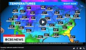
Temperatures across the central U.S. ranged from the single digits in the northern Plains to the upper 50s along the Gulf Coast on Thursday morning, March 10, 2022.
However, it will take until Friday for the truly frigid air to arrive.

Minneapolis will struggle to reach the mid-teens on Friday as temperatures remain about 25 degrees below normal. The mercury is likely to plunge below zero on Friday night, forecasters say.

The cold air will not only affect the northernmost states and has already set record lows as of Thursday morning.

Denver set a record low of 7 below zero Fahrenheit, breaking the previous daily mark for March 10 of 3 below zero that had stood since 1932.

10F.jpg

"Below-normal temperatures will surge across the South Central states on Friday and Saturday as the jet stream dips southward and ushers in a blast of Arctic air," said AccuWeather Meteorologist Alyssa Smithmyer.

One such location will be Wichita, Kansas. After each of the first five days of the month had temperatures 76 degrees or higher, the mercury each day since then in Wichita has failed to top 50 degrees. Typically, a high temperature of 57 degrees is expected heading into the middle of March.

CLICK HERE FOR THE FREE ACCUWEATHER APP

Snow is expected on Thursday night, and temperatures will not recover much on Friday.

"Residents around Wichita can expect highs in the middle 30s on Friday," stated Smithmyer.

The Arctic plunge will even reach the Lone Star State. Highs have reached 80 degrees twice already this month in Dallas, but temperatures will be nowhere near that as the week winds down.

page-5-2.jpg

The forecast high of 68 degrees on Thursday, very close to the normal high of 66, will be a distant memory in Dallas by Friday. In fact, some wintry precipitation is expected.

"Temperatures on Friday will only be in the 30s with a mixture of rain, sleet and snow in the forecast, followed by a freeze-up Friday night," said AccuWeather Senior Meteorologist Alex Sosnowski.

With the sun getting higher in the sky and the days getting longer as March presses on, cold air does not often have the same staying power that it would have a month or two ago. The temperature roller coaster will continue into the weekend as warmth begins to build.

page-4-2.jpg

Residents in Wichita, and other cities such as Springfield, Missouri, will experience daytime temperatures in the 60s as a more forgiving pattern develops across the Central states near the end of this weekend, according to Smithmyer.

While this may be the final cold push of the season in Texas, snow and cold can persist well into April and early May farther to the north. However, it appears that temperatures in much of the Plains and Midwest will range 5-15 degrees above normal for most of next week.


Meanwhile in Spain:

Since yesterday, a meter of snow has sometimes fallen in the Cévennes! Impressive images of Mont Lozère this Sunday afternoon. ( © Samuel Martinez)

1647188416400.png
This Sunday: rain from the north in Languedoc (floods in the Hérault)! Snow on the Massif Central. http://meteo-express.com/previsions

1647191089270.jpeg
CNN
Over 25 million people are under freeze warnings across the South this morning behind yesterday's winter storm that dumped around foot of snow across portions of the Northeast.

73-car pileup occurred amid whiteout conditions in Pennsylvania, drivers said A massive winter storm wreaked havoc on roadways Saturday as it dumped heavy snow and unleashed damaging winds up and down the East Coast.
Mar. 12, 2022 8:36 PM PDT
1647190257223.png

1647191288987.jpeg

1647191706112.jpeg
 
Back
Top Bottom