Turkey
Apocalyptic sights of the unusual cold front in the country.
Animals froze in place, standing, sometimes while walking, due to a rapid drop in temperature.
You are using an out of date browser. It may not display this or other websites correctly.
You should upgrade or use an alternative browser.
You should upgrade or use an alternative browser.
The Ice Age Cometh! Forget Global Warming!
- Thread starter Gaby
- Start date

Snow fell for the first time in three decades in Antalya, Turkey
In the central part of the Turkish city of Antalya, known as one of the resorts popular among Russians, it snowed for the first time in 29 years, TASS reports.
Bad weather came to Turkey on January 21, the residents of Istanbul even had to temporarily stop using personal vehicles and some flights. The amount of snow in some places reached 60 centimeters.
Government agencies have urged residents of areas where precipitation is particularly heavy not to leave their homes unless absolutely necessary.
According to weather forecasts, Istanbul residents will have to endure precipitation at least until the end of the week, although on January 26 the snowfall should become less intense.
At the moment, several traffic jams have formed on the republican highways due to the uncleaned roadbed and accidents. The road from Istanbul to Ankara was also blocked for several hours.
-------------------------------------
In neighboring Greece, the situation is not much better than in Turkey. Athens is buried in snow (about 40 centimeters):
----------------------------------
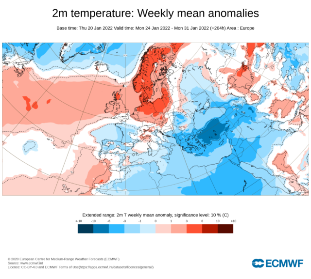
At the same time, in the far north of Europe, the weather seems to be going crazy the other way:
In Murmansk (Russia) on January 24, a temperature record was set. At noon the thermometer showed +5.2. The previous absolute maximum of the day was +3.3 (1992). At the same time, 2.5 thousand km to the south, in snowy Rostov-on-Don, it was -6.8.
From the point of view of logic, it seems that the climate has turned upside down. In part, this is true: the Arctic cold has poured south, while the subtropical heat is carried out in the Arctic.
The attached weather map from the European Center for Medium-Range Forecasts shows the weekly anomaly in air temperature from 24 to 31 January. The positive (red) anomaly is clearly visible in the north and in the center of Europe, while the south of Eastern Europe is colored in cold (blue) tones.
 www.gismeteo.ru
In the central part of the Turkish city of Antalya, known as one of the resorts popular among Russians, it snowed for the first time in 29 years, TASS reports.
Bad weather came to Turkey on January 21, the residents of Istanbul even had to temporarily stop using personal vehicles and some flights. The amount of snow in some places reached 60 centimeters.
Government agencies have urged residents of areas where precipitation is particularly heavy not to leave their homes unless absolutely necessary.
According to weather forecasts, Istanbul residents will have to endure precipitation at least until the end of the week, although on January 26 the snowfall should become less intense.
At the moment, several traffic jams have formed on the republican highways due to the uncleaned roadbed and accidents. The road from Istanbul to Ankara was also blocked for several hours.
-------------------------------------
In neighboring Greece, the situation is not much better than in Turkey. Athens is buried in snow (about 40 centimeters):
----------------------------------
At the same time, in the far north of Europe, the weather seems to be going crazy the other way:
In Murmansk (Russia) on January 24, a temperature record was set. At noon the thermometer showed +5.2. The previous absolute maximum of the day was +3.3 (1992). At the same time, 2.5 thousand km to the south, in snowy Rostov-on-Don, it was -6.8.
From the point of view of logic, it seems that the climate has turned upside down. In part, this is true: the Arctic cold has poured south, while the subtropical heat is carried out in the Arctic.
The attached weather map from the European Center for Medium-Range Forecasts shows the weekly anomaly in air temperature from 24 to 31 January. The positive (red) anomaly is clearly visible in the north and in the center of Europe, while the south of Eastern Europe is colored in cold (blue) tones.
Климат перевернулся: +5 в Мурманске против 72 см свежего снега в Крымске
В то время как в Заполярье наблюдается рекордная оттепель, на юге Европейской России установилась аномально снежная погода.
www.gismeteo.ru
Croatian meteo portal says that a temperature record was broken in Montenegro, with this morning's low of -33.2 °C.

Kosanica this morning, photo: vijesti.me
The morning was very cold throughout the region, and in Montenegro the absolute temperature record fell. According to Montenegrin media, the country has the lowest air temperature in the history of measurements.
In the town of Kosanica in the municipality of Pljevlja, frigid -33.2 °C was measured this morning, confirmed Dušan Pavićević, director of the Meteo Center. The previous record was held by Rožaja in the north of the country, where in 1985 -32 ° C was measured.
A very cold morning was recorded throughout BiH. The following locations are singled out, Sokolac (-23.3 ° C), Bjelašnica (-19.3 ° C), Kupres (-16.7 ° C)… (PR / IM).
Kosanica this morning, photo: vijesti.me
At the same time, in the far north of Europe, the weather seems to be going crazy the other way: In Murmansk (Russia) on January 24, a temperature record was set. At noon the thermometer showed +5.2. The previous absolute maximum of the day was +3.3 (1992). At the same time, 2.5 thousand km to the south, in snowy Rostov-on-Don, it was -6.8.
From the point of view of logic, it seems that the climate has turned upside down. In part, this is true: the Arctic cold has poured south, while the subtropical heat is carried out in the Arctic.
The attached weather map from the European Center for Medium-Range Forecasts shows the weekly anomaly in air temperature from 24 to 31 January. The positive (red) anomaly is clearly visible in the north and in the center of Europe, while the south of Eastern Europe is colored in cold (blue) tones.
Климат перевернулся: +5 в Мурманске против 72 см свежего снега в Крымске
В то время как в Заполярье наблюдается рекордная оттепель, на юге Европейской России установилась аномально снежная погода.
I remember reading this recently:
Also not addressed is NASA’s longstanding research showing that while Earth’s overall temperature trends colder during prolonged bouts of low solar activity (such as today’s descent into the next Grand Solar Minimum, which likely commenced during Solar Cycle 24), not all regions experience the chill. As visualized in NASA’s ‘Maunder Minimum Reconstruction Map’ (shown below), areas such as the Arctic, Alaska and the North Atlantic actually warm during spells of otherwise ‘global’ cooling.
Temp change between 1780 (a year of normal solar activity) and 1680 (a year within the depths of the Maunder Minimum) — NASA.

Perhaps in this next phase of global cooling, depending on global air and water currents, Russia and Scandinavia will actually enjoy some more warmth as well? Fascinating!
Notice that similar spikes occurred during previous Solar cycles - see for example the red arrow during Solar cycle 24 - without them deviating from the smoothed average. In other terms, the spike might not announce a "terminator event":It did however also bring to mind this prediction of a terminator event, which, whilst it may off, maybe there's something to it, since this cycle is, for now, stronger than predicted; as i think the Terminator theory proposes. I don't know enough about it to say either way, but i've included some of the details in the 2nd quote for reference for those that do have a better understanding:

Global cooling (ice Age) can due to several factors. Weak Solar Cycle is one factor (Maunder minimum for example) but irrespective of the amplitude on the Solar Cycle, you can have have an ice Age due cometary impacts (the younger Dryas, or closer to us the Late Antiquity Little Ice Age ca. 540 AD)
Last edited:
Notice that similar spikes occurred during previous Solar cycles - see for example the red arrow during Solar cycle 24 - without them deviating from the smoothed average. In other terms, the spike might not announce a "terminator event":
View attachment 53981
According the article i quoted, the actual data for 2020-21 "has exceeded predictions for 15 straight months.", whereas the spike in that graph for 2021 is 6 months? Can it be considered to be the same?
If these Terminator Events occur "from 10 to 15 years", it's ~11 years since that other spike?
Difficult to say, since we somehow compare apples with oranges. One should aware that predictions are just that and they are often subjected to multiple revisions, like for the Solar Cycle 24 (see image below). Researchers notice spikes relative to the projected Solar cycle 25, but these spikes are going to be less prominent when compared to the actual Solar cycle 25, since it outperforms they predictions.According the article i quoted, the actual data for 2020-21 "has exceeded predictions for 15 straight months.", whereas the spike in that graph for 2021 is 6 months? Can it be considered to be the same?


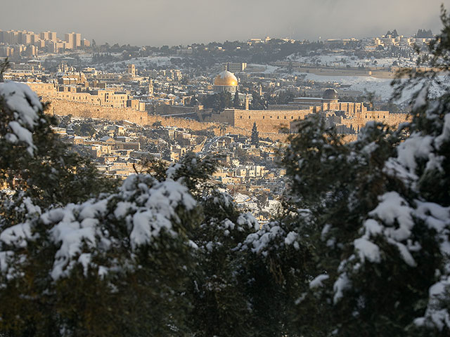
Winter storm "Elpis" in Israel: snow in Jerusalem and other mountainous areas of the country
 www.newsru.co.il
Снежный Иерусалим после зимней бури. Фоторепортаж - there are a lot of photos
www.newsru.co.il
Снежный Иерусалим после зимней бури. Фоторепортаж - there are a lot of photos
Israel continues to live through the winter storm, which has been given the name "Elpis", accompanied by snowfall in mountainous areas. The day before, snow fell in Jerusalem and a stable snow cover about 20 cm thick formed over a large area.
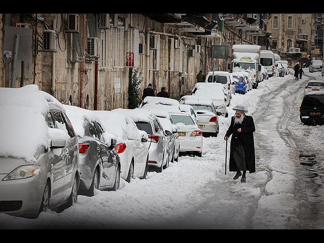
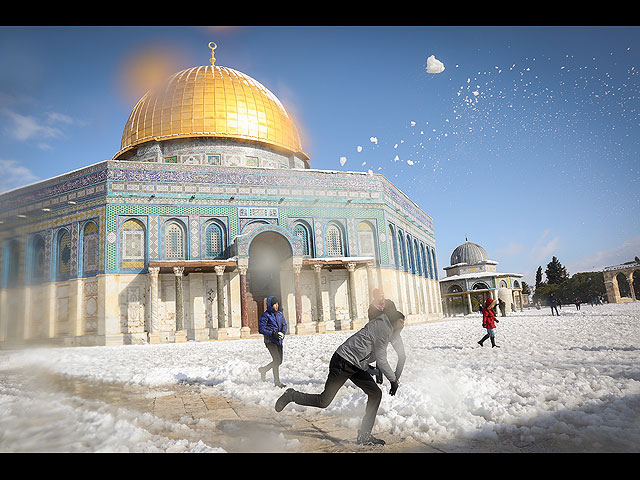
Mountainous areas in the north and in the center of Israel are covered with snow. Heavy snowfall continues on Mount Hermon (resort closed to visitors and will be closed tomorrow). It is also snowing on other peaks of the Golan Heights and the Upper Galilee. The day before, snow fell on the Hebron highlands, in Gush Etzion and in some parts of Samaria.

Kibbutz Ein Zivan, Golan Heights
-------------------------------------------------- ------------------
In addition, the snowstorm also battered the capital of Jordan, Amman:
-------------------------------------------------- -----------------
And that's not all either. A snowstorm also covered the state of Oman, which is located on the Arabian Peninsula.
Зимняя буря "Элпис" в Израиле: снег в Иерусалиме и других горных районах страны
NEWSru.co.il: новости Израиля и Ближнего Востока, актуальные события в мире. Интервью, опросы, обзоры.
Israel continues to live through the winter storm, which has been given the name "Elpis", accompanied by snowfall in mountainous areas. The day before, snow fell in Jerusalem and a stable snow cover about 20 cm thick formed over a large area.
Mountainous areas in the north and in the center of Israel are covered with snow. Heavy snowfall continues on Mount Hermon (resort closed to visitors and will be closed tomorrow). It is also snowing on other peaks of the Golan Heights and the Upper Galilee. The day before, snow fell on the Hebron highlands, in Gush Etzion and in some parts of Samaria.
Kibbutz Ein Zivan, Golan Heights
-------------------------------------------------- ------------------
In addition, the snowstorm also battered the capital of Jordan, Amman:
-------------------------------------------------- -----------------
And that's not all either. A snowstorm also covered the state of Oman, which is located on the Arabian Peninsula.
And that's not all either. A snowstorm also covered the state of Oman, which is located on the Arabian Peninsula.
This seems to a mistake - see comment under post. Apparently temperature in Oman is about 20C. Likely referring to the situation in Amman, Jordan.
A little sea ice in Greece. Now there's something you don't see every day!
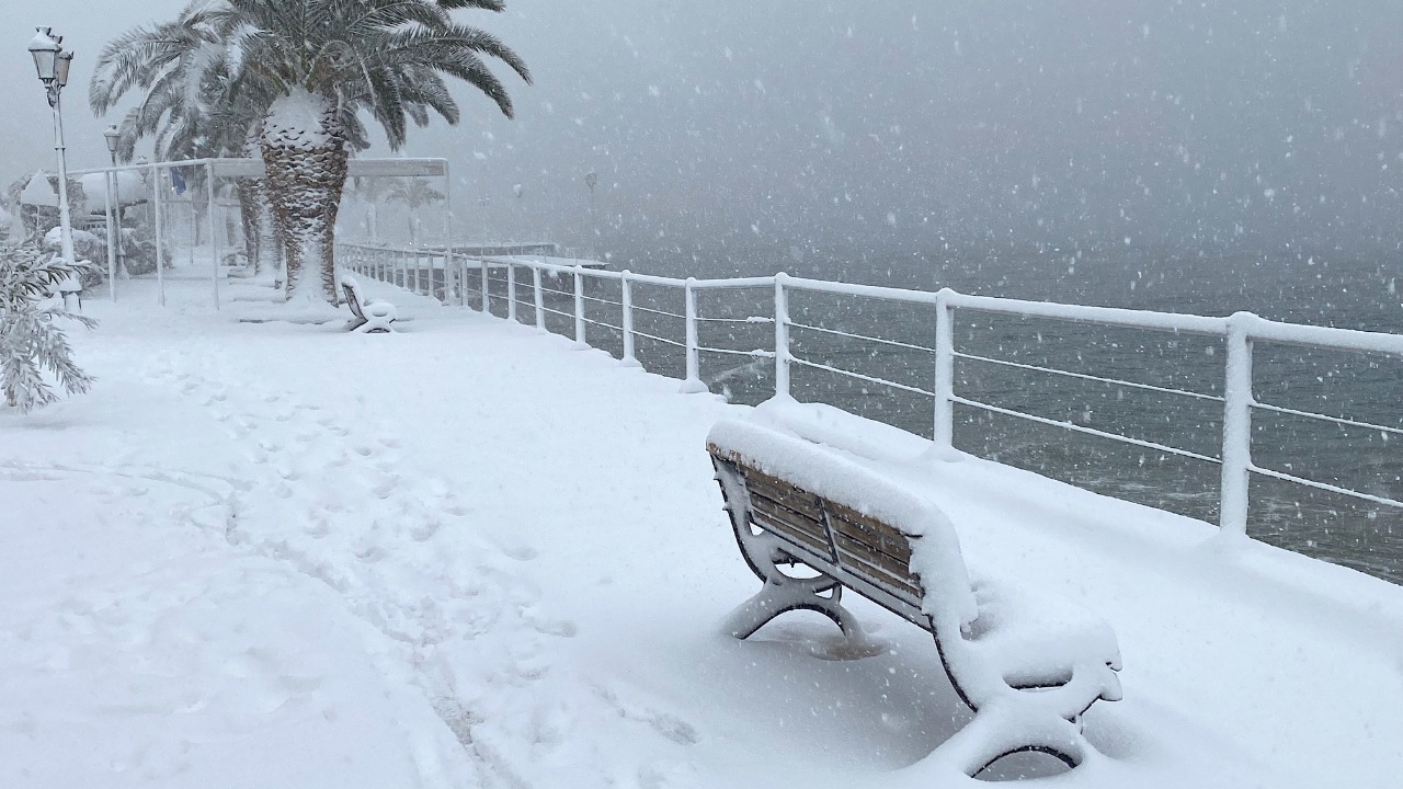
Sea Freezes in Greece in an Once-in-a-Lifetime Phenomenon - GreekReporter.com
Sea ice, usually found in remote polar oceans, appeared on Tuesday in northern Greece as the country is hit with sub-zero temperatures.
greekreporter.com
Yes, the video is probably wrong. At least I searched for the truth for a long time, but found nothing. My google translate confuses Oman/Amman when translating to Arabic.This seems to a mistake - see comment under post. Apparently temperature in Oman is about 20C. Likely referring to the situation in Amman, Jordan.
At the same time, this news says that there was already snow in Oman on January 9 (in the highlands Jebel Akhdar ) - https://www.thenationalnews.com/gulf-news/oman/2022/01/09/oman-feels-like- switzerland-as-early-snow-draws-crowds-to-mountains/
Hehe, I think we are going to be soon used to a few Once-in-a-Lifetime Phenomenons.A little sea ice in Greece. Now there's something you don't see every day!
Sea Freezes in Greece in an Once-in-a-Lifetime Phenomenon - GreekReporter.com
Sea ice, usually found in remote polar oceans, appeared on Tuesday in northern Greece as the country is hit with sub-zero temperatures.greekreporter.com

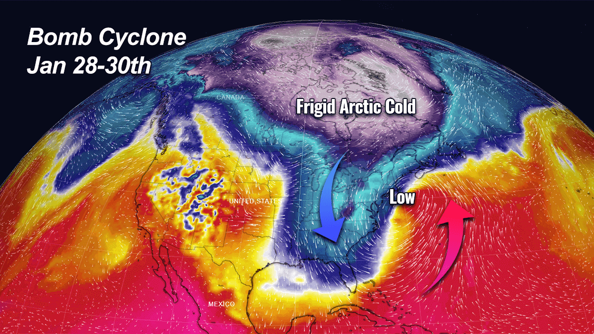
Polar Vortex sends Arctic air towards Florida, triggering a Powerful Nor'Easter Bomb Cyclone that will bury Boston with up to 2 feet of Snow over the weekend
Polar Vortex develops a Nor'Easter storm, with cold Arctic air mass reaching Florida, while bomb cyclone buries the Northeast U.S. with 2 feet of snow.
 www.severe-weather.eu
Heavy snow with blizzard conditions, severe gusty winds, and coastal hazards are quite possible from North Carolina to New England, with the most significant impacts expected in eastern New England where the Nor’Easter will be the strongest and also travel very near the coast.
This Thursday, the cold is spread across a large part of the country. The large pool of extremely cold Arctic air is advancing across the Great Lakes towards the Northeast U.S. from central Canada. Temperatures are even below -10 °F in places across New England. Northwesterly winds are making the cold even worse, especially across the upper Midwest and the Lakes.

The bitter cold pool will intensity further through Friday and spread across the East Coast, reaching far south across the Southeast, including the central Florida peninsula over the weekend. The upcoming days will be significantly colder than normal for the region.
The video animation below reveals the low-pressure system that is forecast to intensify off the East Coast late Friday into Saturday. Significant snowfall will accompany this Nor’Easter storm. The land impact strongly depends on the track of the storm, meaning the closer or more north it travels, the stronger effects will follow regarding winds, heavy snow, and blizzard hazards.
High winds impact could cause coastal flooding, including beach erosion, particularly along the New England coast.
The general weather pattern begins its change this Friday with a cold front surging across the Northeast U.S, bringing another south of frigid cold, Arctic air mass from Canada. Very low windchills will make it dangerous in places. But before we dig deeper into evolution details, let’s first learn what is the main cause and driving factor behind the most significant pattern changes in winter months, known as the Polar Vortex. Continued:
Spaceweather.com
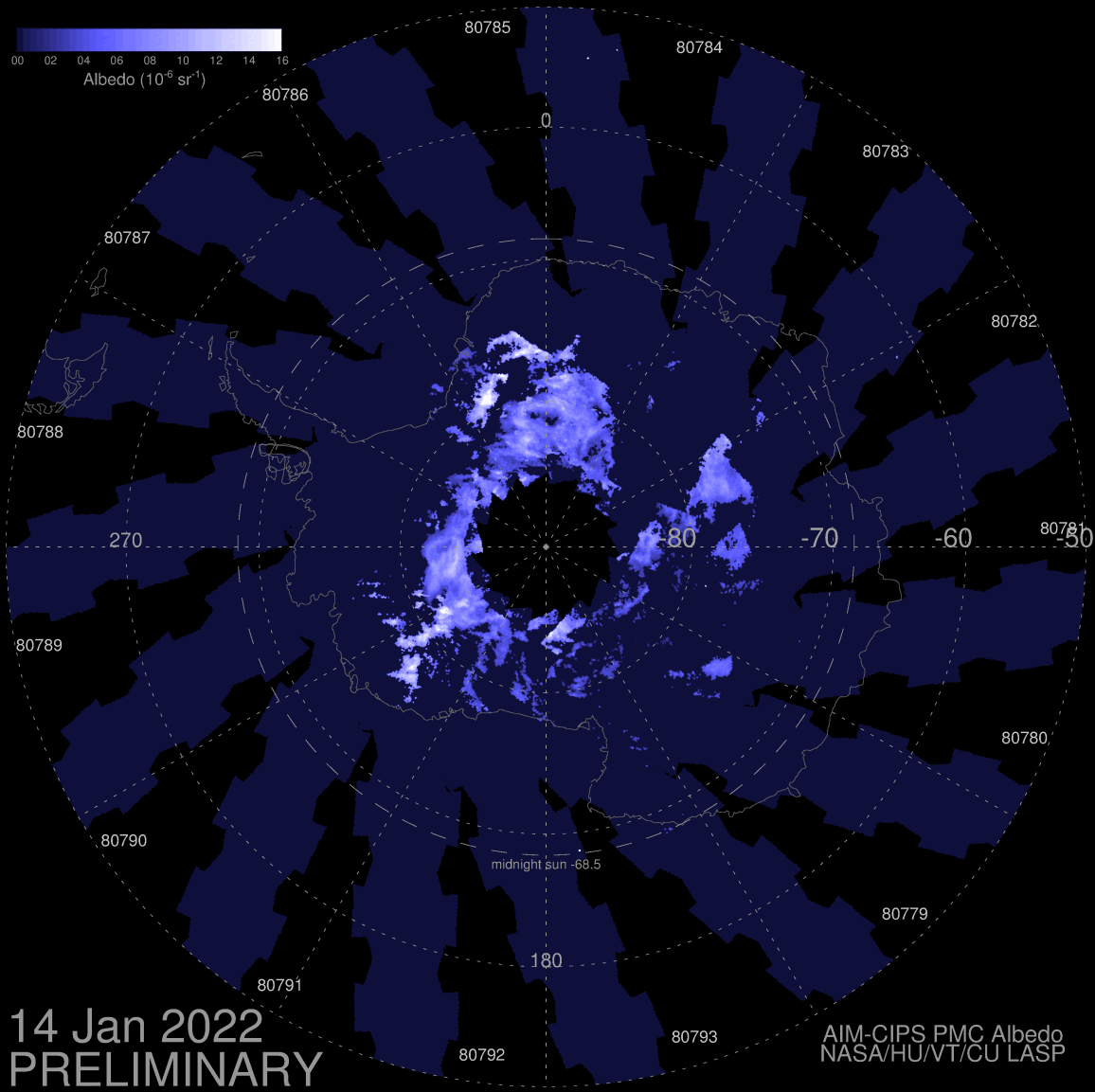
NOCTILUCENT OUTBURST--CONTINUED: Did the Tonga volcano cause an outburst of noctilucent clouds (NLCs)? The jury's still out. However, new data from NASA's AIM spacecraft confirm that something happened in the mesosphere. This 8-day movie shows NLCs blooming around the South Pole after the volcano erupted:
NLCs are Earth’s highest clouds. They form when water vapor rises up from Earth to the edge of space where H2O molecules can stick to specks of meteor dust. NLCs are, literally, frosted meteor smoke.
On Jan. 15th, the Tonga volcano blasted a plume of ash, sulfurous aerosols and water vapor more than 55 km high, only 30 km below where NLCs form. In the days that followed the eruption, natural upwelling may have carried water vapor the rest of the way to the noctilucent zone.
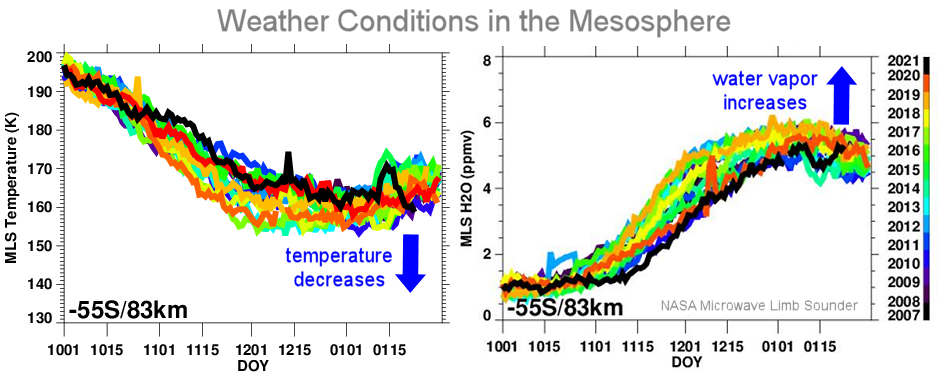
Data from NASA’s Microwave Limb Sounder (MLS) show that weather in the mesosphere (where NLCs are found) did indeed change days after the eruption. Temperatures dropped, and water vapor increased:
Both changes boost noctilucent clouds. But was Tonga responsible? AIM/CIPS Principal Investigator Cora Randall can't help but wonder, saying, "it's speculative, but we're definitely scouring the data to find out." Stay tuned.
Satellite images of snow cover from the bad weather "Elpis" in Viotia Watch the video: Before and after.
In the video edited by the National Observatory of Athens / meteo.gr, we observe the large extent of the snow cover caused by the recent bad weather "Elpis" in the area of Viotia. According to satellite measurements, the area of snow cover in Boeotia and Attica exceeded 6,000,000 acres, ie about 85% of the total area of these two areas was covered with snow between January 24-28, 2022. Satellite images come from the satellite Sentinel-2 of the European Copernicus program. meteo.gr
Facebook:https://www.facebook.com/Meteo.Gr Instagram:https://www.instagram.com/meteogr
METEO FRANCE
A CLOUD COVER - 2022-01-28 - 11:23 UTC

Published: 27/01/2022SUOMI-NPP satellite image, 01/28/2022 at 11:23 UTC: on average, the temperature decreases with altitude by 0.65°C every 100 meters. But sometimes this pattern is reversed. In the presence of an inversion layer, the temperature may increase with altitude. This inversion layer, which can be several hundred meters thick, then acts as a lid that traps fine particles and moisture. This is the case, today, over a large quarter of southwestern France overhung by a layer of low, dense and tenacious clouds.
PREVISIONS METEO FRANCE - Site Officiel de Météo-France - Prévisions gratuites à 15 jours sur la France et sur le monde
METEO FRANCE - Retrouvez les prévisions METEO France de Météo-France à 15 jours, les prévisions météos locales gratuites, complètes et détaillées à 15 jours.
 meteofrance.com
Here are the maximum temperatures forecast for Saturday January 29, 2022:
Brest: 12 Paris: 11 Lyon: 5 Biarritz: 8 Cherbourg: 12 Tours: 9 Clermont-Fd: 6 Perpignan: 19 Rennes: 12 Nancy: 7 Limoges: 9 Marseille: 12 Nantes: 11 Strasbourg: 6 Bordeaux: 9 Nice: 15 Lille: 12 Dijon: 4 Toulouse: 5 Ajaccio: 15
Tomorrow: Saturday 29 Weak rains are sinking in the North and East. the sun resists in the southeast. The sky over the northern half is very cloudy to overcast all day.
Some rains circulate from Normandy to the Vosges then to Burgundy-Franche-Comté and to the north of Auvergne. They are very weak but can locally take on a freezing character on the heights. Thinnings resist from the south of Alsace to the Jura. In the South-West, after a gray start to the day, clearings are developing. However, locally the grayness can persist all day. From the Pyrenees to the Mediterranean to the south of the Massif Central and the Alps, the sun continues to prevail. On the wind side, the Mistral and Tramontana are very attenuated. On the other hand, a westerly wind picks up in the Channel and gives gusts of 60-70 km/h from Haute-Normandie to Hauts de France.
Early morning, we expect -3 to 1 degrees from the North-East to the South-West and in the Center-East, 2 to 6 degrees elsewhere and up to 6 to 9 degrees in Brittany and on the shores of the Mediterranean. The maximum reaches 4 to 7 degrees from the Massif Central in the North-East, 7 to 12 degrees elsewhere, up to 12 to 16 degrees in the South-East.
While part of the North and South-West experienced a very rainy start to the month of #janvier 2022, the weather remained very #sec in the Center and especially in the South-East. In the #BouchesduRhône , this month of January was the 3rd driest since 1959! Computer graphics: @meteofrance